La Nouaye

Last updated

La Nouaye
Lanwaz (Breton)
La Nouaye (35) Mairie.jpg
The town hall of La Nouaye
Location of La Nouaye
La Nouaye
France location map-Regions and departements-2016.svg
Red pog.svg
La Nouaye
Bretagne region location map.svg
Red pog.svg
La Nouaye
Coordinates: 48°09′48″N1°58′41″W / 48.1633°N 1.9781°W / 48.1633; -1.9781
Country France
Region Brittany
Department Ille-et-Vilaine
Arrondissement Rennes
Canton Montfort-sur-Meu
Intercommunality Montfort Communauté
Government
  Mayor (20202026) Fabienne Bondon [1]
Area
1
2.77 km2 (1.07 sq mi)
Population
 (Jan. 2020) [2]
353
  Density130/km2 (330/sq mi)
Time zone UTC+01:00 (CET)
  Summer (DST) UTC+02:00 (CEST)
INSEE/Postal code
35203 /35137
Elevation38–76 m (125–249 ft)
1 French Land Register data, which excludes lakes, ponds, glaciers > 1 km2 (0.386 sq mi or 247 acres) and river estuaries.

La Nouaye (Breton : Lanwaz) is a commune in the department of Ille-et-Vilaine in Brittany in the northwest of France.

Contents

Population

Inhabitants of La Nouaye are called Lanoysiens in French. [3]

Historical population
YearPop.±% p.a.
1968121    
1975107−1.74%
1982201+9.42%
1990202+0.06%
1999236+1.74%
2008272+1.59%
2007257−5.84%
2012329+5.06%
2017357+1.65%
Source: INSEE [4]

Geography

The commune of La Nouaye is part of Montfort-sur-Meu county. It comes under the control of Rennes. It is surrounded by Montfort-sur-Meu, Bédée, Iffendic, Breteil, Pleumeleuc, Talensac, Saint-Gonlay.
It stretches over 272 hectares and it is mostly made of agricultural land.
Two brooks cross the village, one demarcating Iffendic and La Nouaye, the other crossing the town in the North of its territory.

History

La Nouaye is an old parish, probably dating from the 9th century. It was written Lanoas in 1189, Lamnoê in 1516, La Nouais in the 18th century and Lanouaye in 1872.
The parish of La Nouaye, enclaved in the diocese of Saint-Malo, was part of the deanery of Bobital, coming under the diocese of Dol and which was under the term of Saint Etienne. During the year II of the Republic, we could count 201 inhabitants like in 1982.

Tourism

Tourism management in Montfort-sur-Meu" is entrusted by Montfort Community to the Tourist Office of the district of Montfort.

Buildings and touristic places

Buildings

Saint Hubert church and wayside cross The church, built at the end of the 15th century, is one of the most beautiful of the district of Montfort, thanks to the porch and the wayside cross. This last is located in the churchyard adjoining the church Saint Hubert. The porch allowed the sick and the leprous to attend the service, hence its name "the leprous porch". The relics of the wayside cross are classified Historical Monument.

Church of La Nouaye with its porch Church of La Nouaye.JPG
Church of La Nouaye with its porch

The leper hospital It was located at the place name "la ville es malades" and was burnt in 1591.

Touristic places

Le Circuit des 3 rivières The circuit starts in the town centre of La Nouaye, in the avenue called "allée du Calvaire". The hike lasts 3h30, on a distance of 15 km. You have to follow the yellow marking to discover the surroundings of La Nouaye and Bédée.
Le circuit de Blavon The starting point is near the town hall of La Nouaye for a 9 km hike lasting approximately 2h15, following the yellow marking. Passable path the whole year.

See also

Related Research Articles

The following is a list of the 27 cantons of the Ille-et-Vilaine department, in France, following the French canton reorganisation which came into effect in March 2015:

<span class="mw-page-title-main">Gaël</span> Commune in Brittany, France

Gaël is a commune in the Ille-et-Vilaine department in Brittany in northwestern France.

<span class="mw-page-title-main">Arrondissement of Rennes</span> Arrondissement in Brittany, France

The arrondissement of Rennes is an arrondissement of France in the Ille-et-Vilaine department in the Brittany region. It has 109 communes. Its population is 599,717 (2016), and its area is 2,228.4 km2 (860.4 sq mi).

<span class="mw-page-title-main">Saint-Ouen-des-Alleux</span> Commune in Brittany, France

Saint-Ouen-des-Alleux is a commune in the Ille-et-Vilaine department in Brittany in northwestern France.

<span class="mw-page-title-main">Bréal-sous-Montfort</span> Commune in Brittany, France

Bréal-sous-Montfort is a commune in the Ille-et-Vilaine department in the region in Brittany in northwestern France.

<span class="mw-page-title-main">Rennes Métropole</span> Métropole in Brittany, France

Rennes Métropole is the métropole, an intercommunal structure, centred on the city of Rennes. It is located in the Ille-et-Vilaine department, in the Brittany region, western France. It was created in January 2015, replacing the previous Communauté d'agglomération de Rennes, which had itself succeeded in 2000 to the previous district created in 1970 with less powers than the current métropole. Its area is 705.0 km2. Its population was 451,762 in 2018, of which 217,728 in Rennes proper.

<span class="mw-page-title-main">Breteil</span> Commune in Brittany, France

Breteil is a commune in the department of Ille-et-Vilaine in Brittany. It is located in northwestern France.

<span class="mw-page-title-main">Bédée</span> Commune in Brittany, France

Bédée is a commune in the department of Ille-et-Vilaine in Brittany.
It is located in the northwest of France and is labeled as a village étape since 2009.

<span class="mw-page-title-main">Montfort-sur-Meu</span> Commune in Brittany, France

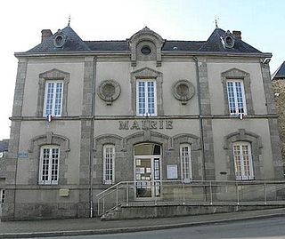
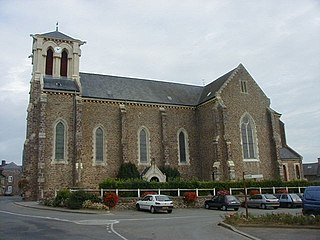
Montfort-sur-Meu is a commune in the department of Ille-et-Vilaine in Brittany in the northwest of France.

<span class="mw-page-title-main">Iffendic</span> Commune in Brittany, France

Iffendic is a commune in the department of Ille-et-Vilaine in Brittany. It is located in the North West of France.

<span class="mw-page-title-main">Talensac</span> Commune in Brittany, France

Talensac is a commune in the department of Ille-et-Vilaine in Brittany in the northwest of France.

<span class="mw-page-title-main">Pleumeleuc</span> Commune in Brittany, France

Pleumeleuc is a commune in the department of Ille-et-Vilaine in Brittany in the northwest of France.

<span class="mw-page-title-main">Goven</span> Commune in Brittany, France

Goven is a commune in the Ille-et-Vilaine department in Brittany in northwestern France.

<span class="mw-page-title-main">Saint-Marcan</span> Commune in Brittany, France

Saint-Marcan is a commune in the Ille-et-Vilaine department in Brittany in northwestern France.

<span class="mw-page-title-main">Saint-Gonlay</span> Commune in Brittany, France

Saint-Gonlay is a commune in the department of Ille-et-Vilaine in Brittany in the northwest of France.

<span class="mw-page-title-main">Saint-Germain-sur-Ille</span> Commune in Brittany, France

Saint-Germain-sur-Ille is a commune in the Ille-et-Vilaine department of Brittany in northwestern France.

<span class="mw-page-title-main">Ille-et-Vilaine's 3rd constituency</span> Constituency of the National Assembly of France

The 3rd constituency of Ille-et-Vilaine is a French legislative constituency in the Ille-et-Vilaine département. Like the other 576 French constituencies, it elects one MP using the two-round system, with a run-off if no candidate receives over 50% of the vote in the first round.

<span class="mw-page-title-main">Meu</span> River in France

The Meu is an 84.1 km (52.3 mi) long river in the Côtes-d'Armor and Ille-et-Vilaine départements, north western France. Its source is at Saint-Vran, 2.4 km (1.5 mi) west of the village. It flows generally southeast. It is a right tributary of the Vilaine into which it flows at Goven, 5.7 km (3.5 mi) northeast of the village.

Montfort Communauté is an intermunicipal structure in the department of Ille-et-Vilaine, in Brittany, France. It was established on 14 December 1992. Its seat is Montfort-sur-Meu. Its area is 194.4 km2, and its population was 25,830 in 2018. It borders Rennes Métropole to the east, CC de Saint-Méen Montauban to the northwest and CC de Brocéliande to the south.

<span class="mw-page-title-main">Canton of Montfort-sur-Meu</span> Canton in Brittany, France

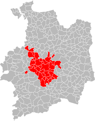
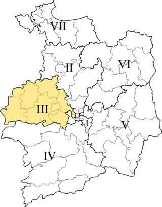
The canton of Montfort-sur-Meu is an administrative division of the Ille-et-Vilaine department, in northwestern France. At the French canton reorganisation which came into effect in March 2015, it was expanded from 11 to 15 communes. Its seat is in Montfort-sur-Meu.

References

  1. "Répertoire national des élus: les maires". data.gouv.fr, Plateforme ouverte des données publiques françaises (in French). 9 August 2021.
  2. "Populations légales 2020". The National Institute of Statistics and Economic Studies. 29 December 2022.
  3. Ille-et-Vilaine, www.habitants.fr
  4. Population en historique depuis 1968, INSEE