
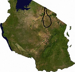
Tanzania is administratively divided into thirty-one regions.

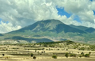
Lake Manyara is a lake located in Monduli District of Arusha Region, Tanzania and is the seventh-largest lake of Tanzania by surface area, at 470-square-kilometre (180 sq mi). It is a shallow, alkaline lake in the Natron-Manyara-Balangida branch of the East African Rift. The northwest quadrant of the lake is included within Lake Manyara National Park and it is part of the Lake Manyara Biosphere Reserve, established in 1981 by UNESCO as part of its Man and the Biosphere Programme.
Manyara Region is one of Tanzania's 31 administrative regions. The regional capital is the town of Babati. According to the 2012 national census, the region had a population of 1,425,131, which was lower than the pre-census projection of 1,497,555. For 2002-2012, the region's 3.2 percent average annual population growth rate was tied for the third highest in the country. It was also the 22nd most densely populated region with 32 people per square kilometre.

Babati Rural District is a district of Manyara Region of Tanzania, East Africa. The administrative capital of the district is Babati town, 172 km (107 mi) south of Arusha. The district covers an area of 6,069 km2 (2,343 sq mi), a large proportion (640 km2) of which is covered by the water bodies of Lake Babati, Lake Burunge and Lake Manyara. The district is bordered to the north by Arusha Region, to the south east by Simanjiro District, to the south by Dodoma Region, to the south west by Hanang District, and to the north west by Mbulu District. Babati Urban District is located within the district.

Arusha Region is one of Tanzania's 31 administrative regions and is located in the north of the country. The region's capital and largest city is the city of Arusha. The region is bordered by Kajiado County and Narok County in Kenya to the north, the Kilimanjaro Region to the east, the Manyara and Singida Regions to the south, and the Mara and Simiyu regions to the west. Arusha Region is home to Ngorongoro Conservation Area, a UNESCO World Heritage Site. The region is comparable in size to the combined land and water areas of the state of Maryland in the United States.
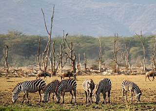
Lake Manyara National Park is a protected area in Tanzania's Arusha and Manyara Regions, situated between Lake Manyara and the Great Rift Valley. It is administered by the Tanzania National Parks Authority, and covers an area of 325 km2 (125 sq mi) including about 230 km2 (89 sq mi) lake surface. More than 350 bird species have been observed on the lake.

Mbulu District is one of the six districts of the Manyara Region of Tanzania. It is bordered to the north by the Arusha Region and Lake Eyasi, to the east by the Babati Rural District, to the south by the Hanang District, and to the west by the Singida Region.

Lake Elmenteita is a soda lake, in the Great Rift Valley, about 120 km northwest of Nairobi, Kenya.
Mto wa Mbu is an administrative ward and town in the Monduli district of the Arusha Region of Tanzania. According to the 2012 census, the ward had a total population of 11,405. The name Mto wa Mbu means " The river of Mosquitoes " in the Swahili Language.
Mbugwe or Mbuwe (Kimbugwe) is a Bantu language of spoken by the Mbugwe people of Lake Manyara in the Manyara Region of Central Tanzania. Mbugwe is estimated to be spoken by some 34,000 people.

Tanzania contains some 20 percent of the species of Africa's large mammal population, found across its reserves, conservation areas, marine parks, and 17 national parks, spread over an area of more than 42,000 square kilometres (16,000 sq mi) and forming approximately 38 percent of the country's territory. Wildlife resources of Tanzania are described as "without parallel in Africa" and "the prime game viewing country". Serengeti National Park, the country's second largest national park area at 14,763 square kilometres (5,700 sq mi), is located in northern Tanzania and is famous for its extensive migratory herds of wildebeests and zebra while also having the reputation as one of the great natural wonders of the world. The Ngorongoro Conservation Area, established in 1959, is a UNESCO World Heritage Site and inhabited by the Maasai people. Its Ngorongoro Crater is the largest intact caldera in the world.

Lake Manyara Airport is an airport serving the Lake Manyara National Park in the Arusha Region of Tanzania.

The Mbulu Highlands is a plateau in north-central Tanzania.

Babati is a town in Babati Urban District of Manyara Region of Tanzania. It is the administrative capital of Babati Urban District and Babati Rural District and also the administrative capital of Manyara Region.

Tanzanian Air Services Ltd, operating as Tanzanair, is an air charter company in Tanzania. Founded in 1969 by Dinos John Samaras, it was the first private air operator in the country. It has an engineering facility near Terminal I of the Julius Nyerere International Airport for aircraft maintenance. It is also an authorised Cessna service centre.

The Tarangire River is a perennial river located in central Manyara Region in the eastern branch of the East African Rift Valley, within northern Tanzania.
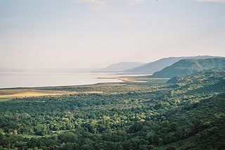
The Lake Manyara Biosphere Reserve is a UNESCO Biosphere Reserve in the depression of the East African Rift Valley in the Lake Manyara Basin in Arusha Region of northern Tanzania. The reserve is managed by Tanzanian Lake Manyara National Park.
The TarangireEcosystem is a geographical region in Africa. It is located in northern Tanzania and extends between 2.5 and 5.5 degrees south latitudes and between 35.5 and 37 degrees east longitudes.
Cannabis in Tanzania is illegal but remains the most common drug and it is produced for different usage, such as domestic usage and exporting. It is locally known as bangi. Tanzania is one among multiple countries in Africa that produce cannabis in large quantities.
The Southern Eastern Rift is a freshwater ecoregion in Kenya and Tanzania.
