
Klamath Falls is a city in and the county seat of Klamath County, Oregon, United States. The city was originally called Linkville when George Nurse founded the town in 1867. It was named after the Link River, on whose falls the city was sited. The name was changed to Klamath Falls in 1893. The population was 20,840 at the 2010 census. The city is on the southeastern shore of the Upper Klamath Lake and approximately 25 miles (40 km) north of the California–Oregon border.
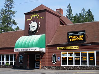
Gilchrist is an unincorporated community in Klamath County, Oregon, United States on U.S. Route 97 between Bend and Klamath Falls.

The Modoc are a Native American people who originally lived in the area which is now northeastern California and central Southern Oregon. They are currently divided between Oregon and Oklahoma and are enrolled in either of two federally recognized tribes, the Klamath Tribes in Oregon and the Modoc Tribe of Oklahoma, now known as the Modoc Nation.

The Klamath River flows 257 miles (414 km) through Oregon and northern California in the United States, emptying into the Pacific Ocean. By average discharge, the Klamath is the second largest river in California after the Sacramento River. It drains an extensive watershed of almost 16,000 square miles (41,000 km2) that stretches from the arid country of south-central Oregon to the temperate rainforest of the Pacific coast. Unlike most rivers, the Klamath begins in the high desert and flows toward the mountains – carving its way through the rugged Cascade Range and Klamath Mountains before reaching the sea. The upper basin, today used for farming and ranching, once contained vast freshwater marshes that provided habitat for abundant wildlife, including millions of migratory birds. Most of the lower basin remains wild, with much of it designated wilderness. The watershed is known for this peculiar geography, and the Klamath has been called "a river upside down" by National Geographic magazine.

The Pit River is a major river draining from northeastern California into the state's Central Valley. The Pit, the Klamath and the Columbia are the only three rivers in the U.S. that cross the Cascade Range.

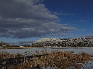
Upper Klamath Lake is a large, shallow freshwater lake east of the Cascade Range in south-central Oregon in the United States. The largest body of fresh water by surface area in Oregon, it is approximately 25 miles (40 km) long and 8 miles (13 km) wide and extends northwest from the city of Klamath Falls. It sits at an average elevation of 4,140 feet (1,260 m).

The Williamson River of south-central Oregon in the United States is about 100 miles (160 km) long. It drains about 3,000 square miles (7,800 km2) east of the Cascade Range. Together with its principal tributary, the Sprague River, it provides over half the inflow to Upper Klamath Lake, the largest freshwater lake in Oregon. The lake's outlet is the Link River, which flows into Lake Ewauna and the Klamath River.
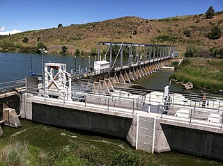
The Link River Dam is a concrete gravity dam on the Link River in the city of Klamath Falls, Oregon, United States. It was built in 1921 by the California Oregon Power Company (COPCO), the predecessor of PacifiCorp, which continues to operate the dam. The dam is owned by the U.S. Bureau of Reclamation.

Central Oregon is a geographic region in the U.S. state of Oregon and is traditionally considered to be made up of Deschutes, Jefferson, and Crook counties. Other definitions include larger areas, often encompassing areas to the north towards the Columbia River, eastward towards Burns, or south towards Klamath Falls. These three counties have a combined population of 200,431 as of the 2010 census, with Deschutes the largest of the three counties, having approximately four times the population of the other two counties combined. As of 2015, the most populous city in the region is Bend, with an estimated 87,014 residents. As defined by the three county definition, Central Oregon covers 7,833 square miles (20,290 km2) of land. Central Oregon has had 3 record tourism years beginning in 2012. Over 2.2 million people visited Central Oregon in 2012 and again in 2013.

Clear Lake Reservoir is a reservoir in the Klamath Basin and the Modoc National Forest, in northwestern Modoc County, California.

Algoma is an unincorporated community on the east shore of Upper Klamath Lake, in Klamath County, Oregon, United States. It is about 8 miles (13 km) north of the city of Klamath Falls on U.S. Route 97. Algoma was named for the Algoma Lumber Company.

The Klamath Basin is the region in the U.S. states of Oregon and California drained by the Klamath River. It contains most of Klamath County and parts of Lake and Jackson counties in Oregon, and parts of Del Norte, Humboldt, Modoc, Siskiyou, and Trinity counties in California. The 15,751-square-mile (40,790 km2) drainage basin is 35% in Oregon and 65% in California. In Oregon, the watershed typically lies east of the Cascade Range, while California contains most of the river's segment that passes through the mountains. In the Oregon-far northern California segment of the river, the watershed is semi-desert at lower elevations and dry alpine in the upper elevations. In the western part of the basin, in California, however, the climate is more of temperate rainforest, and the Trinity River watershed consists of a more typical alpine climate.

Collier Memorial State Park is a state park in southern Oregon. The park is operated and maintained by the Oregon Parks and Recreation Department. It is located on U.S. Highway 97, approximately 30 miles (48 km) north of Klamath Falls and 105 miles (169 km) south of Bend. The park covers 146 acres (59 ha) along the Williamson River.
The Klamath River is a river in southern Oregon and northern California in the United States. This article describes its course.
Nuss Lake is a small private lake in Klamath Falls, Oregon, United States. It is 0.2 sq mi (0.52 km2) in size, located approximately 6.6 miles from Altamont. The lake sits between the south skirt of Stukel Mountain and Olene Gap to the north.

Klamath was the first and only vessel larger than a launch to operate on Lower Klamath Lake, which straddled the border between the U.S. states of Oregon and California. This vessel is chiefly known for having been hauled overland by rail from Lake Ewauna to Upper Klamath Lake. It was also one of only two licensed merchant vessels ever to operate on lower Klamath Lake. During 1905 to 1909, Klamath was an essential link in a transportation line to Klamath Falls which involved rail, stage coach, and steamer travel. The late arrival of railroads to the Klamath lakes region made riverine and lake transport more important to the area.

Hooligan was a sternwheel-driven steamboat that operated on Upper Klamath Lake and the Wood River in the U.S. state of Oregon, mostly in the towing of barges and log rafts. Built in 1909, Hooligan was sold in 1914, rebuilt as an excursion boat, and renamed Annie Laurie. The last attested powered operation of this vessel was in 1916. It appears to have later been used as an unpowered barge by the California Oregon Power Company, a predecessor to Pacific Power and Light.
The Klamath River Hydroelectric Project is a series of hydroelectric dams and other facilities on the mainstem of the Klamath River, in a watershed on both sides of the California/Oregon border.

The Oregon, California and Eastern Railway (OC&E) was a 64-mile (103 km) rail line between Klamath Falls and Bly in the U.S. state of Oregon. After 70 years of bringing logs from nearby forests to local sawmills, the former railroad right of way was converted to the OC&E Woods Line State Trail.

Lake Modoc is a former lake in California and Oregon, in the location of present-day Upper Klamath Lake, Lower Klamath Lake and Tule Lake. It existed during the Pliocene and Pleistocene epochs, its formation probably influenced by volcanism and faulting. The bed of the former lake had plentiful resources for early humans, and today it is used for agriculture.


