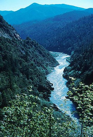
The Klamath River flows 257 miles (414 km) through Oregon and northern California in the United States, emptying into the Pacific Ocean. By average discharge, the Klamath is the second largest river in California after the Sacramento River. It drains an extensive watershed of almost 16,000 square miles (41,000 km2) that stretches from the arid country of south-central Oregon to the temperate rainforest of the Pacific coast. Unlike most rivers, the Klamath begins in the high desert and flows toward the mountains – carving its way through the rugged Cascade Range and Klamath Mountains before reaching the sea. The upper basin, today used for farming and ranching, once contained vast freshwater marshes that provided habitat for abundant wildlife, including millions of migratory birds. Most of the lower basin remains wild, with much of it designated wilderness. The watershed is known for this peculiar geography, and the Klamath has been called "a river upside down" by National Geographic magazine.

Upper Klamath Lake is a large, shallow freshwater lake east of the Cascade Range in south-central Oregon in the United States. The largest body of fresh water by surface area in Oregon, it is approximately 25 miles (40 km) long and 8 miles (13 km) wide and extends northwest from the city of Klamath Falls. It sits at an average elevation of 4,140 feet (1,260 m).

Friant Dam is a concrete gravity dam on the San Joaquin River in central California in the United States, on the boundary of Fresno and Madera Counties. It was built between 1937 and 1942 as part of a U.S. Bureau of Reclamation (USBR) water project to provide irrigation water to the southern San Joaquin Valley. The dam impounds Millerton Lake, a 4,900-acre (2,000 ha) reservoir about 15 miles (24 km) north of Fresno.

Trinity Dam is an earthfill dam on the Trinity River located about 7 miles (11 km) northeast of Weaverville, California in the United States. The dam was completed in the early 1960s as part of the federal Central Valley Project to provide irrigation water to the arid San Joaquin Valley.

The Klamath Project is a water-management project developed by the United States Bureau of Reclamation to supply farmers with irrigation water and farmland in the Klamath Basin. The project also supplies water to the Tule Lake National Wildlife Refuge, and the Lower Klamath National Wildlife Refuge. The project was one of the first to be developed by the Reclamation Service, which later became the Bureau of Reclamation.

The shortnose sucker is a rare species of fish in the family Catostomidae, the suckers. This fish is native to southern Oregon and northern California in the United States. It is a federally listed endangered species of the United States.
PacifiCorp is an electric power company in the western United States.

Condit Hydroelectric Project was a development on the White Salmon River in the U.S. state of Washington. It was completed in 1913 to provide electrical power for local industry, and is listed in the National Register of Historic Places as an engineering and architecture landmark.

The Klamath Basin is the region in the U.S. states of Oregon and California drained by the Klamath River. It contains most of Klamath County and parts of Lake and Jackson counties in Oregon, and parts of Del Norte, Humboldt, Modoc, Siskiyou, and Trinity counties in California. The 15,751-square-mile (40,790 km2) drainage basin is 35% in Oregon and 65% in California. In Oregon, the watershed typically lies east of the Cascade Range, while California contains most of the river's segment that passes through the mountains. In the Oregon-far northern California segment of the river, the watershed is semi-desert at lower elevations and dry alpine in the upper elevations. In the western part of the basin, in California, however, the climate is more of temperate rainforest, and the Trinity River watershed consists of a more typical alpine climate.

Dam removal is the process of demolishing a dam, returning water flow to the river. Arguments for dam removal consider whether their negative effects outweigh their benefits. The benefits of dams include hydropower production, flood control, irrigation, and navigation. Negative effects of dams include environmental degradation, such as reduced primary productivity, loss of biodiversity, and declines in native species; some negative effects worsen as dams age, like structural weakness, reduced safety, sediment accumulation, and high maintenance expense. The rate of dam removals in the United States has increased over time, in part driven by dam age. As of 1996, 5,000 large dams around the world were more than 50 years old. In 2020, 85% percent of dams in the United States are more than 50 years old. In the United States roughly 900 dams were removed between 1990 and 2015, and by 2015, the rate was 50 to 60 per year. France and Canada have also completed significant removal projects. Japan's first removal, of the Arase Dam on the Kuma River, began in 2012 and was completed in 2017. A number of major dam removal projects have been motivated by environmental goals, particularly restoration of river habitat, native fish, and unique geomorphological features. For example, fish restoration motivated the Elwha Ecosystem Restoration and the dam removal on the river Allier, while recovery of both native fish and of travertine deposition motivated the restoration of Fossil Creek.

The John C. Boyle Dam is a hydroelectric dam located in southern Oregon, United States. It is on the upper Klamath River, south (downstream) of Keno, and about 12 miles (19 km) north of the California border. Originally developed and known as Big Bend, the John C. Boyle dam and powerhouse complex was re-dedicated to honor the pioneer hydroelectric engineer who was responsible for the design of virtually all of the Klamath Hydroelectric Project.
The Klamath River is a river in southern Oregon and northern California in the United States. This article describes its course.
The 2002 Klamath River fish kill occurred on the Klamath River in California in September 2002. According to the official estimate of mortality, about 34,000 fish died. Though some counts may estimate over 70,000 adult chinook salmon were killed when returning to the river to spawn, making it the largest salmon kill in the history of the Western United States. Besides the chinook salmon, other fish that perished include: steelhead, coho salmon, sculpins, speckled dace, and Klamath smallscale sucker.
Iron Gate Dam is an earthfill hydroelectric dam on the Klamath River in northern California, outside Hornbrook, California, that opened in 1964. The dam blocks the Klamath River to create the Iron Gate Lake Reservoir. It is the lowermost of a series of power dams on the river, the Klamath River Hydroelectric Project, operated by PacifiCorp. It also poses the first barrier to migrating salmon in the Klamath. The Iron Gate Fish Hatchery was placed just after the dam, hatching salmon and steelhead that are released back into the river. The Iron Gate Dam, along with the John C. Boyle Dam, are two of four on the Klamath River that would be removed under the Klamath Economic Restoration Act. As of February 2016, the states of Oregon and California, the dam owners, federal regulators, and other parties reached an agreement to remove all four dams by the year 2020, pending approval by the Federal Energy Regulatory Commission. On February 25, 2022, the FERC released its final Environmental Impact Statement (EIS) on the dam's removal. The Iron Gate Dam is expected to be removed sometime in 2023 or 2024. A movement to Un-Dam the Klamath has been ongoing for 20 years to remove the dams.
Copco Lake is an artificial lake on the Klamath River in Siskiyou County, California, near the Oregon border in the United States. The lake's waters are impounded by the Copco Number 1 Dam, which was completed in 1922. COPCO was an acronym referring to the California Oregon Power Company, which merged into Pacific Power and Light in 1961, and is now known as Pacificorp.

John C. Boyle Reservoir is an artificial impoundment behind John C. Boyle Dam on the Klamath River in the U.S. state of Oregon. The lake is 16 miles (26 km) west-southwest of Klamath Falls along Oregon Route 66.
The Klamath Basin Restoration Agreement (KBRA) is an American multi-party legal agreement determining river usage and water rights involving the Klamath River and Klamath Basin in the states of California and Oregon. Discussion of the KBRA began in 2005. Congress failed to pass legislation that would implement the KBRA by the January 1, 2016 deadline.
The Klamath River Hydroelectric Project is a series of hydroelectric dams and other facilities on the mainstem of the Klamath River, in a watershed on both sides of the California/Oregon border.

Un-Dam the Klamath (#UnDamtheKlamath) is a social movement in the United States to remove the dams on the Klamath River primarily because they obstruct salmon, steelhead, and other species from accessing the upper basin which provides hundreds of miles of spawning habitat. The dams have also significantly harmed Hupa, Karuk, Klamath, and Yurok lifeways and communities. Copco #1, Copco #2, Iron Gate and J.C. Boyle are the four hydroelectric dams on the Klamath River that are being advocated for removal.


