Lake Osborne, Florida, USA is a 378-acre (152.9 hectares) lake that is part of a system of once natural freshwater lakes lying along the western slope of the coastal ridge in Palm Beach County just west of the Florida Intracoastal Waterway and Atlantic Ocean. It is located within the C-16 drainage basin which occupies approximately 40,031 acres of land (16,200 hectares). Five drainage canals discharge directly to Lake Osborne, and Lake Osborne discharges via the E-4 canal to the C16 and C51 canals to the Lake Worth Lagoon. The lake is bordered on the west by John Prince Memorial Park, and on the east be the City of Lake Worth.
This lake system has been greatly impacted from human activities. It has been extensively modified and reduced in size by dredge and fill activities from urban and residential development; several lakes were completely filled and built upon. The lakes were probably dredged contemporaneous with canal construction in the 1920s or earlier. It is likely that filling of the adjacent wetlands for residential construction occurred at the same time or later. Square Lake and its oxbow lake were dredged for fill in the 1960s and additional dredging occurred in the north lobe of Lake Osborne in the 1970s.
Degradation of the lake's water quality has been ongoing; however, with the elimination of domestic waste discharges 20+ years ago, the water quality has shown improvement. Eutrophication continues as a result of continued discharges of stormwater and agricultural and yard/street runoff. More than two dozen stormwater outfalls are situated within 1000ft of Lake Osborne. In addition to the lake’s loss of habitat value due to urban and residential growth, there has been significant establishment of exotic vegetation, fish, and molluscan species that have disrupted the lake’s ecosystem function.
Lake Osborne is important to Palm Beach County for transporting, processing, and storing stormwater and serving as a water supply reservoir. It is also of considerable value to the County for its scenic value and the recreational opportunities it provides. It is heavily used for boating and fishing as well as a variety of shore-based activities. In addition, John Prince Park, located along the western shoreline of Lake Osborne’s north and central lobe, offers an ecotourism destination for visitors seeking a natural experience where they can enjoy and learn about this ecosystem.
Due to development, vegetated littoral areas in and adjacent to Lake Osborne have been reduced to a fragment of their original size. The lake shorelines predominantly consist of bare sand or mowed grass and exotic and/or invasive vegetation. John Prince Park maintains a lawn like appearance for the majority of the shorelines of Lake Osborne. Within the water column exotic vegetation, such as water lettuce (Pistia stratiotes), water hyacinth (Eichhornia crassipes), hydrilla (Hydrilla verticillata), and now Hygrophila (Hygrophila spp.), pose an ongoing nuisance and are treated with aquatic herbicides. With the loss of aquatic habitat, fish populations within the lake are becoming more represented by rough species, such as Tilapia (Tilapia sp. and Oreochromis sp.).
The Everglades is a natural region of tropical wetlands in the southern portion of the U.S. state of Florida, comprising the southern half of a large drainage basin within the Neotropical realm. The ecosystem it forms is not presently found anywhere else on earth. The system begins near Orlando with the Kissimmee River, which discharges into the vast but shallow Lake Okeechobee. Water leaving the lake in the wet season forms a slow-moving river 60 miles (97 km) wide and over 100 miles (160 km) long, flowing southward across a limestone shelf to Florida Bay at the southern end of the state. The Everglades experience a wide range of weather patterns, from frequent flooding in the wet season to drought in the dry season. Throughout the 20th century, the Everglades suffered significant loss of habitat and environmental degradation.
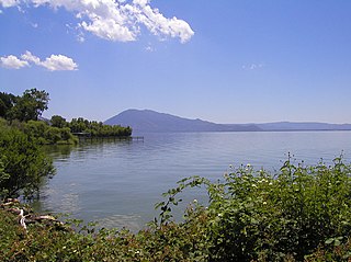
Clear Lake is a natural freshwater lake in Lake County in the U.S. state of California, north of Napa County and San Francisco. It is the largest natural freshwater lake wholly within the state, with 68 square miles (180 km2) of surface area. At an age of 2.5 million years, it is the oldest lake in North America. It is the latest lake to occupy a site with a history of lakes stretching back at least 2,500,000 years.
The St. Clair River is a 40.5-mile-long (65.2 km) river in central North America which flows from Lake Huron into Lake St. Clair, forming part of the international boundary between the Canadian province of Ontario and the U.S. state of Michigan. The river is a significant component in the Great Lakes Waterway, whose shipping channels permit cargo vessels to travel between the upper and lower Great Lakes.
Dredging is the operation of excavating material from a water environment. Possible purposes of dredging include: improving existing water features; reshaping land and water features to alter drainage, navigability, and commercial use; constructing dams, dikes, and other controls for streams and shorelines; and recovering valuable mineral deposits or marine life having commercial value. In all but a few situations the excavation is undertaken by a specialist floating plant, known as a dredger. Dredging is carried out in many different locations and for many different purposes, but the main objectives are usually to recover material of value or use, or to create a greater depth of water. Dredges have been classified as suction or mechanical.
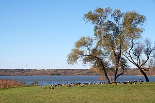
Lake Wingra is a small lake located inside the city limits of the U.S. city of Madison, Wisconsin. The smallest of the five major lakes drained by the Yahara River in Dane County, Lake Wingra is bordered by the University of Wisconsin–Madison Arboretum on the south and west and the City of Madison on the remaining shoreline. The lake is considered an important fishery and is known for spring runs of large muskellunge. Henry Vilas Zoo, Wingra Boats, Wingra Park, and Edgewood College are located on the Lake's northern shoreline. The majority of the shoreline is publicly owned.
Puget Sound is a deep inlet of the Pacific Ocean in Washington, extending south from the Strait of Juan de Fuca through Admiralty Inlet. It was explored and named by Captain George Vancouver for his aide, Peter Puget, in 1792.
Lake Banook is a freshwater lake located in Dartmouth within the Halifax Regional Municipality in Nova Scotia, Canada. It is home to three sprint canoe and kayak clubs, two rowing clubs, and a dragon boat club. It also has a claim to be the birthplace of ice hockey.
A retention basin, sometimes called a wet pond,wet detention basin or stormwater management pond (SWMP), is an artificial pond with vegetation around the perimeter, and includes a permanent pool of water in its design. It is used to manage stormwater runoff to prevent flooding and downstream erosion, and improve water quality in an adjacent river, stream, lake or bay.
The Hillsboro Canal is located in the southeastern portion of Florida within the South Florida Water Management District, and for much of its length forms the border between Broward and Palm Beach counties; however, its western end was entirely in Palm Beach County, until being recently annexed to Broward County-Parkland, FL. It begins at Lake Okeechobee at the S-2 water control structure in South Bay west of Belle Glade, Florida. It passes within the southern border of the Loxahatchee National Wildlife Refuge and flows southeast from there along Loxahatchee Road in a rural, lightly populated area. When it reaches the more heavily built-up region further east, it bends to head due eastward, forming the county line. Near its eastern end at the Intracoastal Waterway, with Boca Raton to the north and Deerfield Beach to the south, it departs from its straight course to go around several curves, but the county boundary continues to follow it at this point. 10 miles of the canal is navigable, and it is popular for recreational boating and fishing.
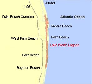
The Lake Worth Lagoon is a lagoon located in Palm Beach County, Florida. It runs parallel to the coast, and is separated from the Atlantic Ocean by barrier beaches, including Palm Beach Island. The lagoon is connected to the Atlantic Ocean by two permanent, man-made inlets.
Lake Apopka is the fourth largest lake in the U.S. state of Florida. It is located 15 miles (24 km) northwest of Orlando, mostly within the bounds of Orange County, although the western part is in Lake County. Fed by a natural spring, rainfall and stormwater runoff, water from Lake Apopka flows through the Apopka-Beauclair Canal and into Lakes Beauclair and Dora. From Lake Dora, water flows into Lake Eustis, then into Lake Griffin and then northward into the Ocklawaha River, which flows into the St. Johns River.
Dipor Bil, also spelt Deepor Beel , is located to the south-west of Guwahati city, in Kamrup district of Assam, India It is a permanent freshwater lake, in a former channel of the Brahmaputra River, to the south of the main river. It is also called a wetland under the Ramsar Convention which has listed the lake in November 2002, as a Ramsar Site for undertaking conservation measures on the basis of its biological and environmental importance.
The Water Resources Development Act of 1992, Pub.L. 102–580, was enacted by Congress of the United States on October 31, 1992. Most of the provisions of WRDA 1992 are administered by the United States Army Corps of Engineers.
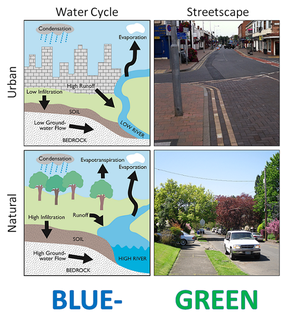
Urban runoff is surface runoff of rainwater created by urbanization. This runoff is a major source of flooding and water pollution in urban communities worldwide.
Boeing Creek is a stream in the U.S. state of Washington, located in the city of Shoreline, just north of Seattle. It is about 1.6 miles (2.6 km) long and empties into Puget Sound. The creek is heavily modified along its course, and in many places has been diverted into culverts. The watershed of Boeing Creek is about 11.2 square miles (29 km2) in size, with two main tributaries aside from the mainstem. The creek takes its name from William Boeing, who built a mansion along the creek in 1913. Despite the river modifications and stormwater pollution, the creek supports a variety of riparian habitats, native animals and fishes.
Water-sensitive urban design (WSUD) is a land planning and engineering design approach which integrates the urban water cycle, including stormwater, groundwater and wastewater management and water supply, into urban design to minimise environmental degradation and improve aesthetic and recreational appeal. WSUD is a term used in the Middle East and Australia and is similar to low-impact development (LID), a term used in the United States; and Sustainable Drainage System (SuDS), a term used in the United Kingdom.
The North Carolina Coastal Federation is a nonprofit organization that works with coastal residents and visitors to protect the beautiful and productive N.C. coast. The four main areas in which the federation operates include: coastal advocacy; environmental education; habitat and water quality restoration and preservation; and support in the improvement and enforcement of environmental laws. The federation headquarters are located in Newport (Ocean), North Carolina, with regional offices in Manteo and Wrightsville Beach, North Carolina. The federation is currently a member of Restore America's Estuaries (RAE).
Living shorelines are a relatively new approach for addressing shoreline erosion and protecting marsh areas. Unlike traditional structures such as bulkheads or seawalls that worsen erosion, living shorelines incorporate as many natural elements as possible which create more effective buffers in absorbing wave energy and protecting against shoreline erosion. The process of creating a living shoreline is referred to as soft engineering, which utilizes techniques that incorporate ecological principles in shoreline stabilization. The natural materials used in the construction of living shorelines create and maintain valuable habitats. Structural and organic materials commonly used in the construction of living shorelines include sand, wetland plants, sand fill, oyster reefs, submerged aquatic vegetation, stones and coir fiber logs.
Springfield Park is a public park in Springfield Gardens, in southeast Queens, New York City. It consists of 23.54 acres (9.53 ha), including the sizable Springfield Lake at its center. It is located on the west side of Springfield Boulevard between 145th Road and 147th Avenue, less than a mile north of JFK Airport. It is maintained by the New York City Department of Parks and Recreation.
The Grand Calumet River is a 13.0-mile-long (20.9 km) river that flows primarily into Lake Michigan. Originating in Miller Beach in Gary, it flows through the cities of Gary, East Chicago and Hammond, as well as Calumet City and Burnham on the Illinois side. The majority of the river's flow drains into Lake Michigan via the Indiana Harbor and Ship Canal, sending about 1,500 cubic feet (42 m3) per second of water into the lake. A smaller part of the flow, at the river's western end, enters the Calumet River and ultimately drains into the Illinois and ultimately the Mississippi River.
This page is based on this Wikipedia article Text is available under the CC BY-SA 4.0 license; additional terms may apply. Images, videos and audio are available under their respective licenses.