The lake is 3 kilometres (2mi) east-north-east of the Albany city centre. The main bitumen roads that border Lake Seppings are Golf Links Road to the east, Troode Street to the north, Collingwood Road, Drew Street/Sleeman Avenue to west and Lake Seppings Drive to the south. The lake is nearly completely surrounded by a 2.7-kilometre (1.7mi) compacted gravel footpath and wooden walkways.[1] A car park for access to the path is located along Golf Links Road.
Lake Seppings is approximately 1.1 kilometres (0.7mi) in length (from north to south) and the north end is approximately 400 metres (1,300ft) in width. The lake narrows toward the southern end and the path crosses the lake approximately 250 metres (820ft) before the southern tip. The lake is situated in the Lake Seppings nature reserve that has a total area of 17.1 hectares (42 acres).[2]
Fauna
Pobblebonk and motorbike frogs at Lake Seppings after dark, December 2016
Around 20,000 years ago the sea level was about 130 metres (430ft) lower than present and the coastline was about 4 kilometres (2.5mi) from the lake's current shoreline. The sea level then rose and the lake was a shallow basin in the sea floor. This explains why cockle shells can be found preserved in the soil. Sea levels then fell to current levels about 8000 years ago leaving Lake Seppings 500 metres (1,640ft) from the coast line.
The lake itself received its English name in 1827 by Major Edmund Lockyer, who named it after his cousins, Robert and John Milligen Seppings.[5]
Lands along the eastern shore of the lake once were part of an estate belonging to Joseph Spencer of Balgarrup near Kojonup in 1884.[6]
In 1887 it was proposed to the Albany Municipal Council by Councillor Robert Andrew Muir that the Council apply to the Government to grant the land surrounding Lake Seppings as a Commonage for the Municipality.[7] The council later voted on the application in 1888 with the intention of establishing a botanical park along the shoreline for a portion of the lake and a timber reserve around the lake.[8]
In 1888 Lake Seppings was declared a Botanic garden. The lake was renamed "Albany Park" in 1900 and protected as a natural wetland. Between 1900 and 1970 the west side of the lake became a rubbish dump until 1972 when the department of fisheries and fauna suggested the lake become a water-fowl reserve.
The Apex club of Albany began work on the bird-walk during the 1980s. The Albany community demanded that the lake be protected and restored in 2000 and in 2004 the walking trail around the lake was completed.
In 2018, a community planting to establish an biodiversity urban corridor planted 22,000 trees and understorey plants in a 1.7 hectares (4 acres) area around the lake to revegetate the fringes and provide habitat for species such as the endangered western ringtail possum.[9]
Dreamtime
The local indigenous Australians are the Noongar people whose name for the lake is Tjuirtgellong which means "The place of the long-necked tortoise". The lake has a special significance to the Noongar who believe it to be the footprint of the spirit Djrat who created the south coast of Western Australia.[10]
Gallery
Lake Seppings Overflow Pond, the water is pumped to the golf course across the road
The bird hide on the western shore of Lake Seppings
Southern end of Lake Seppings
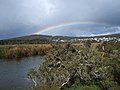
Western shore of Lake Seppings with Mount Adelaide and rainbow in the background
This page is based on this Wikipedia article Text is available under the CC BY-SA 4.0 license; additional terms may apply. Images, videos and audio are available under their respective licenses.