
Orem is a city in Utah County, Utah, United States, in the northern part of the state. It is adjacent to Provo, Lindon, and Vineyard and is approximately 45 miles south of Salt Lake City.

Davis County is a county in northern Utah, United States. As of the 2020 United States Census, the population was 362,679, making it Utah's third-most populous county. Its county seat is Farmington, and its largest city by both population and area is Layton.

Box Elder County is a county at the northwestern corner of Utah, United States. At the 2020 census, the population was 57,666, up from the 2010 figure of 49,975. Its county seat and largest city is Brigham City. The county was named for the box elder trees that abound in the county.

Juab County is a county in western Utah, United States. As of the 2020 United States Census, the population was 11,786. Its county seat and largest city is Nephi.

Utah County is the second-most populous county in the U.S. state of Utah. The county seat and largest city is Provo, which is the state's fourth-largest city, and the largest outside of Salt Lake County. As of the 2020 United States Census, the population was 665,665.
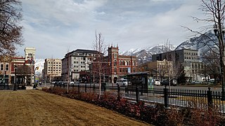
Provo is a city in and the county seat of Utah County, Utah, United States. It is 43 miles (69 km) south of Salt Lake City along the Wasatch Front, and lies between the cities of Orem to the north and Springville to the south. With a population at the 2020 census of 115,162, Provo is the fourth-largest city in Utah and the principal city in the Provo-Orem metropolitan area, which had a population of 526,810 at the 2010 census. It is Utah's second-largest metropolitan area after Salt Lake City.

Draper is a city in Salt Lake and Utah counties in the U.S. state of Utah, about 20 miles (32 km) south of Salt Lake City along the Wasatch Front. As of the 2020 census, the population is 51,017, up from 7,143 in 1990.

Lakeview, also spelled Lake View, is one of the 77 community areas of Chicago, Illinois. Lakeview is located in the city's North Side. It is bordered by West Diversey Parkway on the south, West Irving Park Road on the north, North Ravenswood Avenue on the west, and the shore of Lake Michigan on the east. The Uptown community area is to Lakeview's north, Lincoln Square to its northwest, North Center to its west, and Lincoln Park to its south. The 2020 population of Lakeview was 103,050 residents, making it the second-largest Chicago community area by population.

The Wasatch Front is a major metropolitan region in the north-central part of the U.S. state of Utah. It consists of a chain of mostly contiguous cities and towns stretched along the Wasatch Range from Santaquin in the south to Logan in the north, and containing the cities of Salt Lake City, Provo, Orem, Bountiful, Layton, and Ogden.
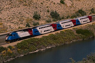
FrontRunner is a commuter rail train operated by the Utah Transit Authority that operates along the Wasatch Front in north-central Utah with service from the Ogden Central Station in central Weber County through Davis County, Salt Lake City, and Salt Lake County to Provo Central station in central Utah County. In 2023, the system had a ridership of 3,736,600, or about 14,200 per weekday as of the second quarter of 2024.

Interstate 15 (I-15) runs north–south in the U.S. state of Utah through the southwestern and central portions of the state, passing through most of the state's population centers, including St. George and those comprising the Wasatch Front: Provo–Orem, Salt Lake City, and Ogden–Clearfield. It is Utah's primary and only north–south interstate highway, as the vast majority of the state's population lives along its corridor; the Logan metropolitan area is the state's only Metropolitan Statistical Area through which I-15 does not pass. In 1998, the Utah State Legislature designated Utah's entire portion of the road as the Veterans Memorial Highway.

Legacy Parkway is an 11.5-mile-long (18.5 km) four-lane controlled-access parkway located almost completely within Davis County in the northern part of the U.S. state of Utah. The parkway travels north from Interstate 215 (I-215) in northwestern Salt Lake City to an interchange named the Wasatch Weave in Farmington with two intermediate interchanges providing access to Woods Cross and Centerville. Wetlands of the nearby Great Salt Lake and nature preserves border the western side of the parkway while the eastern side roughly parallels Union Pacific and Utah Transit Authority rail lines and I-15. On average, between 20,000 and 23,000 vehicles use the parkway daily.

Provo Canyon is located in unincorporated Utah County and Wasatch County, Utah. Provo Canyon runs between Mount Timpanogos on the north and Mount Cascade on the south. The canyon extends from Orem on the west end to Heber City on the east. Provo Canyon is situated to the east of Utah Valley and grants access to the valleys and Uinta Basin regions that lie beyond the Wasatch front.
State Route 52 (SR-52) is a state highway in the U.S. state of Utah, connecting I-15 with US-189 along Orem's 800 North.

State Route 114 (SR-114) is a state highway in the US state of Utah that spans 10.79 miles (17.36 km) in Utah County. The route forms a loop around US-89 and roughly parallels the coast of Utah Lake as it passes through the west side of Provo, Lindon and Orem, eventually terminating in Pleasant Grove. The highway consists of a portion of Center Street and all of Geneva Road. The highway was formed in 1931, the southern terminus initially extending into the east side of Provo. In 1965, the route was truncated to its present state.

The Lake Mountains are a 15-mile-long (24 km) mountain range located on the western edge of the Utah Valley in northwestern Utah County, Utah, United States. The range forms the northwest border of Utah Lake, and its proximity to major population centers allows its use for communication towers, mostly in its north section, bordering Eagle Mountain.

Utah Valley Express, also known as UVX, is a bus rapid transit (BRT) line in central Utah County, Utah, United States. The line is operated by the Utah Transit Authority (UTA) and runs between southwest Orem to south central Provo by way of Utah Valley University (UVU) and Brigham Young University (BYU). It began service with a soft opening on August 13, 2018, while the station platforms were being finished and was formally opened on January 9, 2019. It is the second of several BRT lines that UTA has or is planning in Utah County and the Salt Lake Valley.

The Mount Timpanogos Transit Center was a staffed, open air bus transfer station in southeast Orem, Utah, United States. It functioned as both the Utah Transit Authority's (UTA) customer service center for Utah County, as well as a bus transfer center for UTA's buses in east central Utah Valley. Prior to the opening of the FrontRunner commuter rail extension south to Provo in 2012), it was the busiest bus stop within the entire UTA bus system.
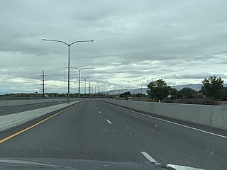
Lakeview Parkway, a yet-to-be-entirely-completed connector street in Utah County, Utah, United States, that is mostly located within the city limits of Provo and runs along length of the south and west sides of the city. The parkway serves the Provo Municipal Airport and the new campus of Provo High School. Upon final completion, it will be a four- to five-lane road running from Geneva Road at 2000 North to South State Street, running along nearly the entire west and south sides of Provo.


