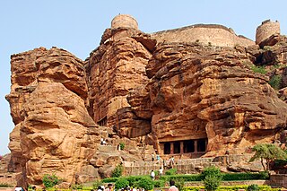
Badami, formerly known as Vatapi, is a town and headquarters of a taluk by the same name, in the Bagalkot district of Karnataka, India. It was the regal capital of the Badami Chalukyas from AD 540 to 757. It is famous for its rock cut structural temples. It is located in a ravine at the foot of a rugged, red sandstone outcrop that surrounds Agastya lake. Badami has been selected as one of the heritage cities for HRIDAY - Heritage City Development and Augmentation Yojana scheme of Government of India.

Bagalkot district, is an administrative district in the Indian state of Karnataka. The district headquarters is located in the town of Bagalkot. The district is located in northern Karnataka and borders Belgaum, Gadag, Koppal, Raichur and Bijapur. The new Bagalkot district was carved out of Bijapur in 1997 via Government of Karnataka directive Notification RD 42 LRD 87 Part III. The bifurcated Bagalkot district consists of nine taluks — Badami, Bagalkot, Bilagi, Guledgudda, Rabkavi Banhatti, Hunagund, Ilkal, Jamakhandi and Mudhol.

North Karnataka is a geographical region consisting of mostly semi-arid plateau from 300 to 730 metres elevation that constitutes the northern part of the Karnataka state in India. It is drained by the Krishna River and its tributaries the Bhima, Ghataprabha, Malaprabha, and Tungabhadra. North Karnataka lies within the Deccan thorn scrub forests ecoregion, which extends north into eastern Maharashtra.

Hunagunda is a taluk in the northern district of Bagalkot in Karnataka, India. Major towns in the taluk are Amingad, Karadi, Hunagunda and Ilkal. Kudalasangama, where the social reformist Basavanna died, is located in the taluk. Hunagunda Taluk also contains Aihole and Pattadkal which were once under the rule of Chalukyas of Badami. Amingad is known for Amingad karadantu, a sweet dish.
Ron is a taluka headquarters in Gadag district, Karnataka in India. Of historical importance, the town was termed Dronapur in ancient times. The temples are believed to be constructed by the ancient architect and warrior-priest Dronacharya.
The Malaprabha River is a tributary of the Krishna River and flows through the state of Karnataka in India. It rises in the Western Ghats at an altitude of 792.4 m (2,600 ft) in the state's Belgaum district. The river joins Krishna River at Kudalasangama in Bagalkot district.

The Badami Chalukya architecture was a temple building idiom that evolved in the 5th – 8th centuries AD in the Malaprabha river basin, in present-day Bagalkot district of Karnataka state of India, under the Chalukya dynasty. This style is sometimes called the Vesara style and Chalukya style, a term that also includes the much later Western Chalukya architecture of the 11th and 12th centuries. Early Chalukya architecture, used by George Michell and others, equates to Badami Chalukya. The earliest Badami Chalukya temples date back to around 450 A.D. in Aihole when the Badami Chalukyas were vassals of the Kadambas of Banavasi. According to historian K.V. Sounder Rajan, the Badami Chalukyas contribution to temple building matched their valor and their achievements in battle.

Temples of North Karnataka
Jalihal is a village in the southern state of Karnataka, India. It is located in the Badami taluk of Bagalkot district in Karnataka.
Hanumasagara, also spelled as Hanumsagara is a village in the Kushtagi taluk of Koppal district in Karnataka state, India.
Adagal is a village in the southern state of Karnataka, India. It is located in the Badami taluk of Bagalkot district in Karnataka.
Agasarakoppa is a village in the southern state of Karnataka, India. It is located in the Badami taluk of Bagalkot district in Karnataka.
Dhannur also spelled as Dhannooru is a village in the Hungund taluk of Bagalkot district in the Indian state of Karnataka.
Katarki, Kataraki, Katharki or Katharaki may refer to:
Gonal is a village in the southern state of Karnataka, India. Administratively, Gonal is under Mangalore gram panchayat, Badami Taluka of Bagalkot District in Karnataka. The village of Gonal is 6 km by road west of the village of Pattadakal and 17 km by road northeast of the town of Badami.
Anawal is a village in the southern state of Karnataka, India. It is located in the Badami taluk of Bagalkot district in Karnataka.
Fakirbhudihal is a village in Bagalkot district Karnataka state of India. It is near Badami.
Haldur is a village in Badami taluka, Bagalkot district, Karnataka state, India.

Pattadakal, formerly known as Raktapura, is a small town in the Bagalkot district of north Karnataka, India. It is famous for its UNESCO world heritage site.
Badami Vidhan Sabha seat is one of 224 assembly constituencies in Karnataka State, in India. It is part of Bagalkot.

