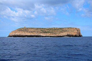
Lampione is a small rocky island located in the Mediterranean Sea, which belongs geographically to the Pelagie Islands and administratively to the comune of Lampedusa e Linosa, Province of Agrigento, region of Sicily, Italy. It is about 200 metres long and 180 metres across, and has an area of 4 hectares and a highest elevation of 36 metres.

Punta Sottile Lighthouse is an active lighthouse on the Favignana Island placed at the extremity of Punta Sottile, the westernmost point of the Island.

Capo Grosso Lighthouse is an active lighthouse on the Levanzo Island placed at the extremity of Capo Grosso, the northernmost point of the Island.

Capo Peloro Lighthouse is an active lighthouse located in Punta del Faro on the Strait of Messina, the most north-eastern promontory of Sicily, settled in the Province of Messina, the place closest to Calabria.

San Vito Lo Capo Lighthouse is an active lighthouse located in the municipality of San Vito Lo Capo on the western coast of Sicily at the end of the promontory, with the same name, between the Gulf of Macari and that of Castellammare.
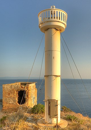
Punta del Diavolo Lighthouse is an active lighthouse located on the western point of Isola San Domino, one of the Tremiti in Apulia on the Adriatic Sea.

Capo Gallo Lighthouse is an active lighthouse located on the northern tip of the promontory of Monte Pellegrino marks the western entrance to the Gulf of Palermo, Sicily on the Tyrrhenian Sea.

Capo Granitola Lighthouse is an active lighthouse located on the south-western headland south of Mazzara del Vallo a region well known for its Almadraba. The tower is well placed in the nearby archeological park Cave di Cusa and is located in the municipality of Campobello di Mazara, Sicily on the Strait of Sicily.

Capo Grecale Lighthouse is an active lighthouse located on the northern eastern tip of the island on the edge of a cliff, in the municipality of Lampedusa, Sicily on the Strait of Sicily.

Capo d'Orlando Lighthouse is an active lighthouse located at the foot of a rocky ridge, north of the municipality of Capo d'Orlando on the Tyrrhenian Sea.

Capo Santa Croce Lighthouse is an active lighthouse located at the extreme tip of the cape, marking the northern end of the Gulf in the municipality of Augusta on the Ionian Sea.
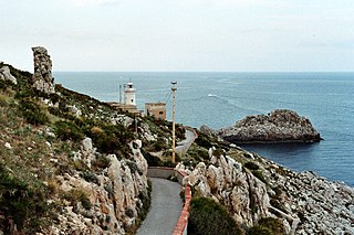
Capo Zafferano Lighthouse is an active lighthouse located at the extreme tip of the homonymy promontory, under a steep ridge, that marks the eastern entrance to the port of Palermo. The lighthouse is in the municipality of Santa Flavia on the Tyrrhenian Sea.
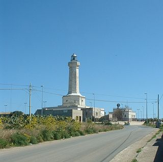
Cozzo Spadaro Lighthouse is an active lighthouse located at the top of a hill in the Quartiere named Cozzo Spadaro in the municipality of Portopalo di Capo Passero, the southernmost comune of Sicily, on the Ionian Sea.

Isola delle Correnti Lighthouse is an active lighthouse located on an islet, 277 metres (909 ft) long and 152 metres (499 ft) wide, connected to mainland by a rocky isthmus on the southernmost tip of Sicily in the municipality of Portopalo di Capo Passero on the Malta Channel.
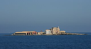
Isolotto Formica Lighthouse is an active lighthouse located on an islet, 302 metres (991 ft) long and 206 metres (676 ft) wide, at 4 nautical miles from Trapani in western Sicily on the Sicily Channel. The island is dominated by a quadrangular fortification, built by the Pallavicino in the mid 1600, and a Tonnara, built by the Florio in the mid 1800, which was closed in 1979. From the 1980s the island is a private property belonging to Mondo X which is involved in the recovery of drug addiction.

Punta Beppe Tuccio Lighthouse is an active lighthouse located on the north eastern tip of the island of Linosa which makes part of the Pelagie Islands in the Channel of Sicily.

Punta Lingua Lighthouse is an active lighthouse located on the south eastern tip of the island of Salina, which makes part of the Aeolian Islands, in the municipality of Santa Marina Salina on the Tyrrhenian Sea.
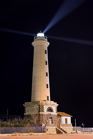
The San Giacomo Lighthouse is an active lighthouse at the root of the east wharf of the commercial harbour of Licata on the Channel of Sicily. The lighthouse takes its name from the homonymous castle once on the site, then later destroyed to make room for the seaport.

Scogli Porcelli Lighthouse is an active lighthouse located 3 nautical miles offshore Trapani on a series of emerging rocks. Scogli Porcelii makes part of Aegadian Islands on the Sicily Channel.

Scoglio Palumbo Lighthouse is an active lighthouse located on an islet 102 metres (335 ft) long and 67 metres (220 ft) wide just 0.6 nautical miles west of the entrance to the port of Trapani on the Sicily Channel.


