| Lantawan | |
|---|---|
| Municipality | |
| Municipality of Lantawan | |
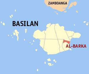
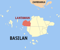
Map of Basilan with Lantawan highlighted | |
Location within the Philippines | |
| Coordinates: 6°39′N121°52′E / 6.65°N 121.87°E Coordinates: 6°39′N121°52′E / 6.65°N 121.87°E | |
| Country | |
| Region | Autonomous Region in Muslim Mindanao (ARMM) |
| Province | Basilan |
| District | Lone District |
| Barangays | 25 (see Barangays) |
| Government [1] | |
| • Type | Sangguniang Bayan |
| • Mayor | Rustam M. Ismael |
| • Electorate | 12,011 voters (2016) |
| Area [2] | |
| • Total | 405.04 km2 (156.39 sq mi) |
| Population (2015 census) [3] | |
| • Total | 24,594 |
| • Density | 61/km2 (160/sq mi) |
| Time zone | UTC+8 (PST) |
| ZIP code | 7301 |
| PSGC | 150703000 |
| IDD : area code | +63 (0)62 |
| Climate type | Tropical climate |
| Income class | 3rd municipal income class |
| Revenue (₱) | 91,738,134.51 (2016) |
| Native languages | Chavacano Yakan Tagalog |
| Website | www |
Lantawan, officially the Municipality of Lantawan, (Tausūg: Lupah Lantawan; Chavacano: Municipalidad de Lantawan; Tagalog : Bayan ng Lantawan), is a 3rd class municipality in the province of Basilan, Philippines. According to the 2015 census, it has a population of 24,594 people. [3]
Tagalog is an Austronesian language spoken as a first language by a quarter of the population of the Philippines and as a second language by the majority. Its standardized form, officially named Filipino, is the national language of the Philippines, and is one of two official languages alongside English.
The Province of Basilan is an island province of the Philippines in the Bangsamoro Autonomous Region. Basilan Island is the largest and northernmost of the major islands of the Sulu Archipelago. It is just off the southern coast of the geographic Zamboanga Peninsula.
The Philippines, officially the Republic of the Philippines, is an archipelagic country in Southeast Asia. Situated in the western Pacific Ocean, it consists of about 7,641 islands that are categorized broadly under three main geographical divisions from north to south: Luzon, Visayas, and Mindanao. The capital city of the Philippines is Manila and the most populous city is Quezon City, both part of Metro Manila. Bounded by the South China Sea on the west, the Philippine Sea on the east and the Celebes Sea on the southwest, the Philippines shares maritime borders with Taiwan to the north, Vietnam to the west, Palau to the east, and Malaysia and Indonesia to the south.
On August 25, 2007, 10 of its barangays were separated and constituted into the new municipality of Hadji Muhtamad. [4] [5] The municipality now only consists of 25 barangays found on Basilan Island.
Lantawan is politically subdivided into 25 barangays. [6]
A barangay or baranggay (, formerly referred to as barrio, is the smallest administrative division in the Philippines and is the native Filipino term for a village, district or ward. In metropolitan areas, the term often refers to an inner city neighbourhood, a suburb or a suburban neighborhood. The word barangay originated from balangay, a kind of boat used by a group of Austronesian peoples when they migrated to the Philippines.
| PSGC | Barangay | Population | ±% p.a. | |||
|---|---|---|---|---|---|---|
| 2015 [3] | 2010 [7] | |||||
| 150703001 | Atong-atong | 9.6% | 2,368 | 1,155 | 14.65% | |
| 150703018 | Bagbagon | 3.4% | 829 | 793 | 0.85% | |
| 150703003 | Baungis | 2.1% | 524 | 515 | 0.33% | |
| 150703019 | Bulan-bulan | 5.9% | 1,463 | 1,333 | 1.79% | |
| 150703004 | Bulanza | 3.1% | 771 | 605 | 4.72% | |
| 150703037 | Calayan | 2.1% | 507 | 452 | 2.21% | |
| 150703026 | Calugusan | 3.5% | 870 | 796 | 1.71% | |
| 150703027 | Canibungan | 7.5% | 1,847 | 1,472 | 4.42% | |
| 150703029 | Landugan | 1.8% | 452 | 390 | 2.85% | |
| 150703007 | Lantawan Proper ( Poblacion ) | 3.7% | 919 | 943 | −0.49% | |
| 150703031 | Lawi-lawi | 4.0% | 994 | 681 | 7.47% | |
| 150703030 | Lawila | 2.6% | 643 | 467 | 6.28% | |
| 150703024 | Lower Bañas | 2.4% | 599 | 550 | 1.64% | |
| 150703008 | Lower Manggas | 4.2% | 1,025 | 598 | 10.80% | |
| 150703036 | Luuk-Maluha | 2.0% | 498 | 491 | 0.27% | |
| 150703011 | Matarling | 3.8% | 929 | 1,337 | −6.70% | |
| 150703012 | Matikang | 3.7% | 918 | 857 | 1.32% | |
| 150703033 | Pamucalin | 5.0% | 1,228 | 1,143 | 1.38% | |
| 150703035 | Paniongan | 2.5% | 612 | 524 | 3.00% | |
| 150703038 | Parian-Baunoh | 4.1% | 1,001 | 843 | 3.32% | |
| 150703021 | Suba-an (Pangasahan) | 3.6% | 895 | 516 | 11.06% | |
| 150703034 | Switch Yakal | 4.3% | 1,056 | 944 | 2.16% | |
| 150703016 | Tairan | 8.6% | 2,104 | 1,562 | 5.84% | |
| 150703025 | Upper Bañas | 2.3% | 571 | 466 | 3.94% | |
| 150703017 | Upper Manggas | 3.9% | 971 | 654 | 7.82% | |
| Total | 24,594 | 20,087 | 3.93% | |||
| Population census of Lantawan | ||
|---|---|---|
| Year | Pop. | ±% p.a. |
| 1960 | 27,493 | — |
| 1970 | 8,528 | −11.03% |
| 1975 | 14,081 | +10.58% |
| 1980 | 17,733 | +4.72% |
| 1990 | 19,340 | +0.87% |
| 1995 | 25,613 | +5.40% |
| 2000 | 27,487 | +1.53% |
| 2007 | 28,978 | +0.73% |
| 2010 | 20,087 | −12.49% |
| 2015 | 24,594 | +3.93% |
| Source: Philippine Statistics Authority [3] [7] [8] [9] | ||
In the 2015 census, Lantawan had a population of 24,594. [3]
The Islamic State of Iraq and the Levant, also known as the Islamic State of Iraq and Syria, officially as the Islamic State (IS) and by its Arabic language acronym Daesh, is a Salafi jihadist militant group and former unrecognised proto-state that follows a fundamentalist, Salafi doctrine of Sunni Islam. ISIL gained global prominence in early 2014 when it drove Iraqi government forces out of key cities in its Western Iraq offensive, followed by its capture of Mosul and the Sinjar massacre.
Abu Sayyaf, unofficially known as the Islamic State of Iraq and the Levant – Philippines Province, is a Jihadist militant and pirate group that follows the Wahhabi doctrine of Sunni Islam. It is based in and around Jolo and Basilan islands in the southwestern part of the Philippines, where for more than four decades, Moro groups have been engaged in an insurgency seeking to make the province independent. The group is considered violent and was responsible for the Philippines' worst terrorist attack, the bombing of Superferry 14 in 2004, which killed 116 people. The name of the group is derived from the Arabic abu, and sayyaf ("swordsmith"). As of 2012, the group was estimated to have between 200 and 400 members, down from 1,250 in 2000. They use mostly improvised explosive devices, mortars and automatic rifles.

Hadji Panglima Tahil, officially the Municipality of Hadji Panglima Tahil, is a 6th class municipality in the province of Sulu, Philippines. According to the 2015 census, it has a population of 6,375 people.

Madamba, officially the Municipality of Madamba, is a 4th class municipality in the province of Lanao del Sur, Philippines. According to the 2015 census, it has a population of 17,756 people.
Maluso, officially the Municipality of Maluso,, is a 4th class municipality in the province of Basilan, Philippines. According to the 2015 census, it has a population of 40,646 people.

Sumisip, officially the Municipality of Sumisip,, is a 1st class municipality in the province of Basilan, Philippines. According to the 2015 census, it has a population of 41,730 people.

Tipo-Tipo, officially the Municipality of Tipo-Tipo,, is a 3rd class municipality in the province of Basilan, Philippines. According to the 2015 census, it has a population of 19,163 people.

Tuburan, officially the Municipality of Tuburan,, is a 2nd class municipality in the province of Basilan, Philippines. According to the 2015 census, it has a population of 20,207 people.

Sultan sa Barongis, officially the Municipality of Sultan sa Barongis, is a 2nd class municipality in the province of Maguindanao, Philippines. According to the 2015 census, it has a population of 22,425 people.

Talayan, officially the Municipality of Talayan, is a 4th class municipality in the province of Maguindanao, Philippines. According to the 2015 census, it has a population of 30,032 people.

Matanog, officially the Municipality of Matanog, is a 4th class municipality in the province of Maguindanao, Philippines. According to the 2015 census, it has a population of 29,770 people.

Guindulungan, officially the Municipality of Guindulungan, is a — municipality in the province of Maguindanao, Philippines. According to the 2015 census, it has a population of 19,911 people.

Rajah Buayan, officially the Municipality of Rajah Buayan, is a — municipality in the province of Maguindanao, Philippines. According to the 2015 census, it has a population of 23,652 people.

Akbar, officially the Municipality of Akbar,, is a — municipality in the province of Basilan, Philippines. According to the 2015 census, it has a population of 17,531 people.

Al-Barka, officially the Municipality of Al-Barka,, is a — municipality in the province of Basilan, Philippines. According to the 2015 census, it has a population of 20,905 people.

Hadji Mohammad Ajul, officially the Municipality of Hadji Mohammad Ajul,, is a — municipality in the province of Basilan, Philippines. According to the 2015 census, it has a population of 19,307 people.
Ungkaya Pukan, officially the Municipality of Ungkaya Pukan,, is a — municipality in the province of Basilan, Philippines. According to the 2015 census, it has a population of 18,441 people.
Pandag, officially the Municipality of Pandag, is a — municipality in the province of Maguindanao, Philippines. According to the 2015 census, it has a population of 25,057 people.
Northern Kabuntalan, officially the Municipality of Northern Kabuntalan, is a 5th class municipality in the province of Maguindanao, Philippines. According to the 2015 census, it has a population of 25,232 people.

Omar, officially the Municipality of Omar, is a — municipality in the province of Sulu, Philippines. According to the 2015 census, it has a population of 25,116 people.

Hadji Muhtamad, officially the Municipality of Hadji Muhtamad,, is a — municipality in the province of Basilan, Philippines. According to the 2015 census, it has a population of 25,085 people.

Tabuan-Lasa, officially the Municipality of Tabuan-Lasa,, is a — municipality in the province of Basilan, Philippines. According to the 2015 census, it has a population of 24,188 people.
| This article about a location in the Autonomous Region in Muslim Mindanao is a stub. You can help Wikipedia by expanding it. |