
Coamo is a town and municipality founded in 1579 in the south-central region of Puerto Rico, located north of Santa Isabel; south of Orocovis and Barranquitas; east of Villalba and Juana Díaz; and west of Aibonito and Salinas. Coamo is spread over 10 barrios and Coamo Pueblo – the downtown area and the administrative center of the city. It is both a principal city of the Coamo Micropolitan Statistical Area and the Ponce-Yauco-Coamo Combined Statistical Area.

Santa Isabel is a town and municipality of Puerto Rico located in the southern coast of the island, south of Coamo; east of Juana Díaz; and west of Salinas. Santa Isabel is spread over 7 barrios and Santa Isabel Pueblo. It is the principal city of the Santa Isabel Micropolitan Statistical Area and is part of the Ponce-Yauco-Coamo Combined Statistical Area.

Hacienda Buena Vista, also known as Hacienda Vives, was a coffee plantation located in Barrio Magueyes, Ponce, Puerto Rico. The original plantation dates from the 19th century. The plantation was started by Don Salvador de Vives in 1833.
Water resources and irrigation infrastructure in Peru vary throughout the country. The coastal region, an arid but fertile land, has about two-thirds of Peru’s irrigation infrastructure due to private and public investment aimed at increasing agricultural exports. The Highlands and Amazon regions, with abundant water resources but rudimentary irrigation systems, are home to the majority of Peru's poor, many of whom rely on subsistence or small-scale farming.
While Peru accounts for about four per cent of the world's annual renewable water resources, over 98% of its water is available east of the Andes, in the Amazon region. The coastal area of Peru, with most of economic activities and more than half of the population, receives only 1.8% of the national freshwater renewable water resources. Economic and population growth are taking an increasing toll on water resources quantity and quality, especially in the coastal area of Peru.
Mexico, a classified arid and semi-arid country, has a total land area of 2 million square kilometres, 23% of which is equipped for irrigated agriculture. The agricultural sector plays an important role in the economic development of the country accounting for 8.4 of agricultural gross domestic product (GDP) and employing 23% of the economically active population. Irrigated agriculture contributes about 50% of the total value of agricultural production and accounts for about 70% of agriculture exports. Mexico's government initiated a number of structural reforms in the water sector aimed to introduce modern water management and irrigation.
Bolivia’s government considers irrigated agriculture as a major contributor to "better quality of life, rural and national development." After a period of social unrest caused by the privatization of water supply in Cochabamba and La Paz, the government of Evo Morales is undertaking a major institutional reform in the water resources management and particularly in the irrigation sector, aimed at: (i) including indigenous and rural communities in decision making, (ii) integrating technical and traditional knowledge on water resources management and irrigation, (iii) granting and registering water rights, (iv) increasing efficiency of irrigation infrastructure, (v) enhancing water quality, and (v) promoting necessary investment and financial sustainability in the sector. Bolivia is the first country in Latin America with a ministry dedicated exclusively to integrated water resources management: the Water Ministry.
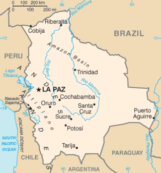
Bolivia has traditionally undertaken different water resources management approaches aimed at alleviating political and institutional instability in the water sector. The so-called water wars of 2000 and 2006 in Cochabamba and El Alto, respectively, added social unrest and conflict into the difficulties of managing water resources in Bolivia. Evo Morales’ administration is currently developing an institutional and legal framework aimed at increasing participation, especially for rural and indigenous communities, and separating the sector from previous privatization policies. In 2009, the new Environment and Water Resources Ministry was created absorbing the responsibilities previously under the Water Ministry. The Bolivian Government is in the process of creating a new Water Law – the current Water Law was created in 1906 – and increasing much needed investment on hydraulic infrastructure.
The water resources management system in Uruguay has been influenced by the general sense of water as an abundant resource in the country. Average annual rainfall is 1,182 mm, representing a contribution of 210 km3 annually throughout its territory. In 2002, the per capita renewable water resources was 41,065 cubic meters, way above the world average 8,467 m3 in 2006. Uruguay also shares one of the largest groundwater reserves in the world, the Guarani Aquifer, with Brazil, Argentina, Paraguay. The Guarani aquifer covers 1,200,000 square kilometers and has a storage capacity of 40,000 km3.

San Diego Creek is a 16-mile (26 km) urban waterway flowing into Upper Newport Bay in Orange County, California in the United States. Its watershed covers 112.2 square miles (291 km2) in parts of eight cities, including Irvine, Tustin, and Costa Mesa. From its headwaters in Laguna Woods the creek flows northwest to its confluence with Peters Canyon Wash, where it turns abruptly southwest towards the bay. Most of the creek has been converted to a concrete flood control channel, but it also provides important aquatic and riparian habitat along its course and its tidal estuary.

Puquios are ancient systems of subterranean aqueducts which allow water to be transported over long distances in hot dry climates without loss of much of the water to evaporation. Puquios are found in the coastal deserts of southern Peru, especially in the Nazca region, and northern Chile. Forty-three puquios in the Nazca region were still in use in the early 21st century and relied upon to bring fresh water for irrigation and domestic use into desert settlements. The origin and dating of the Nazca puquios is disputed, although some archaeologists have estimated that their construction began about 500 CE by indigenous people of the Nazca culture.
The Coamo River is a river in southern Puerto Rico. It runs for approximately 24 miles or 38 kilometers through the municipalities of Coamo and Santa Isabel, where it empties into the Caribbean Sea at Coamo Bay in Boca Velázquez. Its source lies in the Cordillera Central, on the Pulguillas ward (barrio).
Juan Cortada y Quintana was a Puerto Rican politician, businessman, and landowner. He served as Mayor of Ponce, Puerto Rico, from 27 September 1872 to 4 February 1874.

Xochitlán Todos Santos (municipality) is one of the 217 town and municipalities of Puebla. It was founded in 1895. Xochitlán, name composed of the Nahua words, "xochitl", flower, and "tlan", together. The full name means "among the flowers". According to the last census by INEGI in 2010, the municipality has a total population of 6,049 inhabitants, which gives it an approximate population density of 37 inhabitants per square kilometer. The municipality is located roughly 1.9 km (1.2 mi) above sea level and covers an area of 163.72 km2 (63.21 sq mi). To the north, it borders the municipalities of Tochtepec and Tecamachalco, to the west is Huitziltepec and Molcaxac, to the south are the municipalities of Juan N. Mendez and Tepexi de Rodríguez, and to the east are Yehualtepec and the municipality of Tlacotepec de Benito Juárez.
Guatemala faces substantial resource and institutional challenges in successfully managing its national water resources. Deforestation is increasing as the global demand for timber exerts pressure on the forests of Guatemala. Soil erosion, runoff, and sedimentation of surface water is a result of deforestation from development of urban centers, agriculture needs, and conflicting land and water use planning. Sectors within industry are also growing and the prevalence of untreated effluents entering waterways and aquifers has grown alongside.
Timoteo Luberza de San Martín was a nineteenth-century Puerto Rican engineer from Ponce, Puerto Rico. He was responsible for the 1875 Ponce water supply system, including the dam in Rio Portugues, and the Calle del Agua masonry arch aqueduct in barrio Portugues Urbano in Ponce. In 1864, he served briefly as mayor of the nearby town of Yauco. He is best remembered for designing Plaza del Mercado de Ponce.
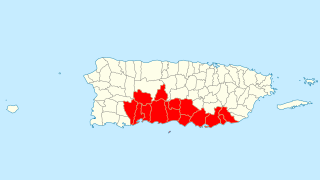
Porta Caribe is a tourism region in southern Puerto Rico. It was established in 2003 by the Puerto Rico Tourism Company, an agency of the Government of Puerto Rico. When created in 2003 it consisted of 14 municipalities in the south central zone. With the creation of the neighboring Porta Cordillera zone in July 2012, the municipalities of Adjuntas and Jayuya were transferred to the newly created Porta Cordillera zone and Porta Caribe became a 12-municipality tourism region. The name Porta Caribe translates to "Doorway to the Caribbean." Its executive director is Maritza W. Ruiz Cabán.
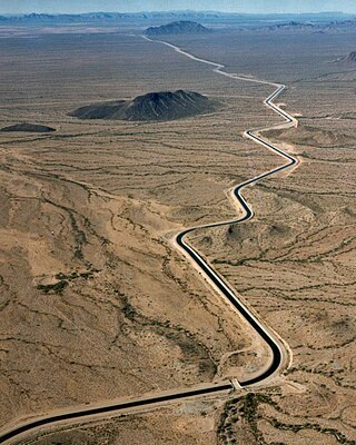
An aqueduct is a watercourse constructed to carry water from a source to a distribution point far away. In modern engineering, the term aqueduct is used for any system of pipes, ditches, canals, tunnels, and other structures used for this purpose. The term aqueduct also often refers specifically to a bridge carrying an artificial watercourse. Aqueducts were used in ancient Greece, ancient Egypt, and ancient Rome. The simplest aqueducts are small ditches cut into the earth. Much larger channels may be used in modern aqueducts. Aqueducts sometimes run for some or all of their path through tunnels constructed underground. Modern aqueducts may also use pipelines. Historically, agricultural societies have constructed aqueducts to irrigate crops and supply large cities with drinking water.

The Molino Dam or Prinza Water Dam is a gravity dam on the Zapote River located on the border between Barangay San Nicolas I, Bacoor, Cavite and Barangay Talon Dos, Las Piñas, Metro Manila, Philippines. It was built by hand in the 19th century to irrigate the surrounding rice field in Las Piñas and Bacoor.

