Leading Creek (Ohio)

Last updated
Leading Creek
Leading Creek Ohio.jpg
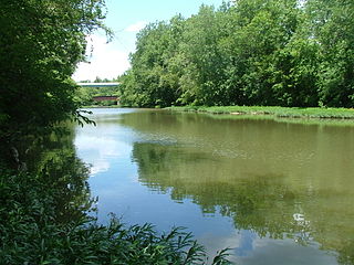
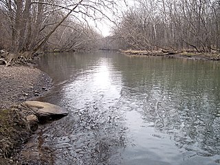
Leading Creek in Rutland Township in 2007
Leading Creek Ohio map.png
Map of Leading Creek and its watershed
Location
Country United States
State Ohio
Counties Athens, Meigs
Physical characteristics
Source 
 - location Lee Township, Athens County
 - coordinates 39°14′09″N82°13′09″W / 39.2359064°N 82.2190367°W / 39.2359064; -82.2190367 [1]
 - elevation820 ft (250 m) [2]
River mouth Ohio River
 - location Middleport
 - coordinates 38°59′04″N82°04′18″W / 38.9845230°N 82.0715312°W / 38.9845230; -82.0715312 Coordinates: 38°59′04″N82°04′18″W / 38.9845230°N 82.0715312°W / 38.9845230; -82.0715312 [1]
 - elevation538 ft (164 m) [1]
Length29.5 mi (47.5 km)
Basin features
Basin size150 sq mi (390 km2)
Tributaries 
 - left Little Leading Creek

Leading Creek is a tributary of the Ohio River, 29.5 miles (47.5 km) long, [3] in southeastern Ohio in the United States. Via the Ohio River, it is part of the watershed of the Mississippi River, draining an area of 150 square miles (390 km2) [3] on the unglaciated portion of the Allegheny Plateau. The creek's headwaters are in southern Athens County and it flows for most of its length in western Meigs County; its tributaries also drain a small area of northeastern Gallia County. [4]

Tributary stream or river that flows into a main stem river or lake

A tributary or affluent is a stream or river that flows into a larger stream or main stem river or a lake. A tributary does not flow directly into a sea or ocean. Tributaries and the main stem river drain the surrounding drainage basin of its surface water and groundwater, leading the water out into an ocean.

Ohio River river in the midwestern United States

The Ohio River is a 981-mile (1,579 km) long river in the midwestern United States that flows southwesterly from western Pennsylvania south of Lake Erie to its mouth on the Mississippi River at the southern tip of Illinois. It is the second largest river by discharge volume in the United States and the largest tributary by volume of the north-south flowing Mississippi River that divides the eastern from western United States. The river flows through or along the border of six states, and its drainage basin includes parts of 15 states. Through its largest tributary, the Tennessee River, the basin includes several states of the southeastern U.S. It is the source of drinking water for three million people.

United States Federal republic in North America

The United States of America (USA), commonly known as the United States or America, is a country composed of 50 states, a federal district, five major self-governing territories, and various possessions. At 3.8 million square miles, the United States is the world's third or fourth largest country by total area and is slightly smaller than the entire continent of Europe's 3.9 million square miles. With a population of over 327 million people, the U.S. is the third most populous country. The capital is Washington, D.C., and the largest city by population is New York City. Forty-eight states and the capital's federal district are contiguous in North America between Canada and Mexico. The State of Alaska is in the northwest corner of North America, bordered by Canada to the east and across the Bering Strait from Russia to the west. The State of Hawaii is an archipelago in the mid-Pacific Ocean. The U.S. territories are scattered about the Pacific Ocean and the Caribbean Sea, stretching across nine official time zones. The extremely diverse geography, climate, and wildlife of the United States make it one of the world's 17 megadiverse countries.

Contents

Leading Creek rises northwest of Albany in Lee Township in Athens County and initially flows southward into Meigs County, through Columbia Township, past the community of Carpenter; then southeastward through Salem, Rutland, and Salisbury townships, through the community of Langsville. It flows into the Ohio River at the south end of the village of Middleport. [4]

Albany, Ohio Village in Ohio, United States

Albany is a village in Athens County, Ohio, United States. The population was 828 at the 2010 census.

Lee Township, Athens County, Ohio Township in Ohio, United States

Lee Township is one of the fourteen townships of Athens County, Ohio, United States. The 2010 census found 2,729 people in the township.

Columbia Township, Meigs County, Ohio Township in Ohio, United States

Columbia Township is one of the twelve townships of Meigs County, Ohio, United States. The 2000 census found 1,018 people in the township.

Little Leading Creek

Little Leading Creek is a tributary of Leading Creek and flows for its entire length in Meigs County. It rises at 39°08′54″N82°09′16″W / 39.14833°N 82.15444°W / 39.14833; -82.15444 in Scipio Township and flows southward through the village of Rutland to 39°01′32″N82°08′15″W / 39.02556°N 82.13750°W / 39.02556; -82.13750 in Rutland Township. [4] [5] It is 10.6 miles (17.1 km) long and drains an area of 25.6 square miles (66 km2). [3]

Scipio Township, Meigs County, Ohio Township in Ohio, United States

Scipio Township is one of the twelve townships of Meigs County, Ohio, United States. The 2000 census found 1,050 people in the township.

Rutland, Ohio Village in Ohio, United States

Rutland is a village in Meigs County, Ohio, United States. The population was 393 at the 2010 census.

See also

Related Research Articles

Sunday Creek (Ohio) river in the United States of America

Sunday Creek is a tributary of the Hocking River, 27.2 miles (43.8 km) long, in southeastern Ohio in the United States. Via the Hocking and Ohio Rivers, it is part of the watershed of the Mississippi River, draining 139 square miles (360 km²) in a mainly rural area of the Allegheny Plateau region. Its name is locally said to derive from early white settlers who in 1802 reached the creek on a Sunday, and so named it after the day of their discovery.

Shade River river in the United States of America

The Shade River is a tributary of the Ohio River in southeastern Ohio in the United States. Via the Ohio River, it is part of the watershed of the Mississippi River, draining an area of 221 square miles (570 km2) on the unglaciated portion of the Allegheny Plateau. The Shade River is 17.4 miles (28.0 km) long, or 38.2 miles (61.5 km) including its west branch.

Kokosing River river in the United States of America

The Kokosing River (ko-KO-sing) is a tributary of the Walhonding River, 57.2 miles (92.1 km) long, in east-central Ohio in the United States. Via the Walhonding, Muskingum and Ohio Rivers, it is part of the watershed of the Mississippi River, draining an area of 482 square miles (1248 km²). Etymologically, "Kokosing" translates roughly to "River of Little Owls." The Kokosing River rises in Morrow County, northeast of Mount Gilead, and initially flows southwardly. It turns eastwardly near Chesterville and flows through Knox and Coshocton Counties, passing the communities of Mount Vernon, Howard and Gambier. In western Coshocton County the Kokosing joins the Mohican River to form the Walhonding River, about 2 miles (3 km) northwest of Nellie.

Paint Creek (Scioto River tributary) river in the United States of America

Paint Creek is a tributary of the Scioto River, 94.7 mi (152.5 km) long, in south-central Ohio in the United States. Via the Scioto and Ohio Rivers, it is part of the watershed of the Mississippi River. It drains an area of 1,143 mi² (2960 km²).

Rattlesnake Creek (Ohio) river in the United States of America

Rattlesnake Creek is a tributary of Paint Creek, 42.3 mi (68.1 km) long, in south-central Ohio in the United States. Via Paint Creek and the Scioto and Ohio Rivers, it is part of the watershed of the Mississippi River, draining an area of 277 mi² (717 km²). According to the Geographic Names Information System, it has also been known historically as "Rattlesnake Fork."

Little Scioto River (Ohio River tributary) watercourse in the United States of America

The Little Scioto River is a tributary of the Ohio River, about 42.8 miles (68.9 km) long, in southern Ohio in the United States. Via the Ohio River, it is part of the watershed of the Mississippi River, draining an area of 233 square miles (600 km2).

Symmes Creek tributary of the Ohio River in southern Ohio

Symmes Creek is a 76.4-mile-long (123.0 km) tributary of the Ohio River in southern Ohio in the United States. Via the Ohio River, it is part of the watershed of the Mississippi River, draining an area of 357 square miles (920 km2) on the unglaciated portion of the Allegheny Plateau.

Ohio Brush Creek river in the United States of America

Ohio Brush Creek is a 59.9-mile-long (96.4 km) tributary of the Ohio River in southern Ohio in the United States. Via the Ohio River, it is part of the watershed of the Mississippi River, draining an area of 435 square miles (1,130 km2). According to the Geographic Names Information System, it has also been known historically as "Brush Creek," "Elk Creek," and "Little Scioto River"

Moxahala Creek river in the United States of America

Moxahala Creek is a tributary of the Muskingum River, 29.2 miles (47.0 km) long, in southeastern Ohio in the United States. Via the Muskingum and Ohio Rivers, it is part of the watershed of the Mississippi River, draining an area of 301 square miles (780 km²)

Wakatomika Creek river in the United States of America

Wakatomika Creek is a tributary of the Muskingum River, 42.6 mi (68.6 km) long, in central Ohio in the United States. Via the Muskingum and Ohio Rivers, it is part of the watershed of the Mississippi River, draining an area of 234 mi² (606 km²)

Cedar River (Gladwin County, Michigan) river in Clare and Gladwin counties, Michigan, United States

The Cedar River is a 29.0-mile-long (46.7 km) river in the U.S. state of Michigan, flowing through Clare County and Gladwin County.

Salt River is the name of two streams in the U.S. state of Michigan.

Sandy Creek (Ohio) river in the United States of America

Sandy Creek is a tributary of the Tuscarawas River, 41.3 miles (66.5 km) long, in northeastern Ohio in the United States. Via the Tuscarawas, Muskingum and Ohio Rivers, it is part of the watershed of the Mississippi River, draining an area of 503 square miles (1,303 km²).

Nimishillen Creek river in the United States of America

Nimishillen Creek is a tributary of Sandy Creek, 24.5 miles (39.4 km) long, in northeastern Ohio in the United States. Via Sandy Creek and the Tuscarawas, Muskingum and Ohio Rivers, it is part of the watershed of the Mississippi River, draining an area of 187 square miles (484 km²), including the city of Canton.

Wheeling Creek (Ohio) river in the United States of America

Wheeling Creek is a tributary of the Ohio River, 30.2 miles (48.6 km) long, in eastern Ohio in the United States. Via the Ohio River, it is part of the watershed of the Mississippi River, draining an area of 108 square miles (280 km2) on the unglaciated portion of the Allegheny Plateau. It flows for its entire length in Belmont County; its tributaries also drain small areas of south-eastern Harrison County and south-western Jefferson County.

Saganing River river in the United States of America

The Saganing River, also known as Saganing Creek, is a 10.0-mile-long (16.1 km) stream in the U.S. state of Michigan.

Nottawa Creek is a 33.9-mile-long (54.6 km) stream in the U.S. state of Michigan that flows into the St. Joseph River at 42°00′15″N85°23′40″W, approximately three miles east of the village of Mendon.

Little Hocking River watercourse in the United States of America

The Little Hocking River is a small tributary of the Ohio River, 18.4 miles (29.6 km) long, in southeastern Ohio in the United States. Via the Ohio River, it is part of the watershed of the Mississippi River, draining an area of 102 square miles (260 km2) on the unglaciated portion of the Allegheny Plateau. The river flows for its entire length in southwestern Washington County; its tributaries also drain a small area of southeastern Athens County.

Margaret Creek is a stream and state waterway in Athens and Meigs Counties, Ohio. Along with Monday, Sunday, and Federal Creeks, Margaret Creek is a principal tributary to the Hocking River. The confluence with the Hocking river is on the west side of the city of Athens, Ohio. The stream was named after Margaret Snowden, the first white woman settler in Athens County.

Raccoon Creek (Ohio) river in Gallia County, United States of America

Raccoon Creek is a 114-mile-long (183 km) stream that drains parts of five Ohio counties. It originates in Hocking County, Ohio. It flows through Vinton County and Gallia County and a corner of Meigs County. Its largest tributary, Little Raccoon Creek, arises in Jackson County. The watershed also includes part of Athens County, drained by another tributary, Hewett Fork. The other major tributaries are Elk Fork, located entirely in Vinton County, and Brushy Fork, which is mostly in Vinton County with a small area in Hocking County.

References

  1. 1 2 3 Geographic Names Information System. "Geographic Names Information System entry for Leading Creek (Feature ID #1066794)" . Retrieved 2011-10-12.
  2. Google Earth elevation for GNIS source coordinates. Retrieved on 2011-03-07.
  3. 1 2 3 Ohio Department of Natural Resources (August 2001). "Gazetteer of Ohio Streams" (PDF). pp. 63–64. Retrieved 2011-10-12.
  4. 1 2 3 Ohio Atlas & Gazetteer. Yarmouth, Me.: DeLorme. 1991. pp. 79–80, 87. ISBN   0-89933-233-1.
  5. Geographic Names Information System. "Geographic Names Information System entry for Little Leading Creek (Feature ID #1042671)" . Retrieved 2011-10-12.