Leaf, Mississippi

Last updated

Leaf, Mississippi
USA Mississippi location map.svg
Red pog.svg
Leaf
Usa edcp location map.svg
Red pog.svg
Leaf
Coordinates: 31°01′33″N88°47′44″W / 31.02583°N 88.79556°W / 31.02583; -88.79556
Country United States
State Mississippi
County Greene
Area
[1]
  Total1.18 sq mi (3.06 km2)
  Land1.18 sq mi (3.06 km2)
  Water0.00 sq mi (0.00 km2)
Elevation
95 ft (29 m)
Population
 (2020)
  Total62
  Density52.54/sq mi (20.29/km2)
Time zone UTC-6 (Central (CST))
  Summer (DST) UTC-5 (CDT)
ZIP code
39456
GNIS feature ID693696 [2]

Leaf is a census-designated place and unincorporated community in Greene County, Mississippi, United States. [2]

Contents

Leaf is located east of Leaf River Wildlife Management Area, within the eastern boundary of De Soto National Forest.

The town is named for the Leaf River, which flows a few miles east. [3]

It was first named as a CDP in the 2020 Census which listed a population of 62. [4]

History

Leaf was settled in 1838, and originally called "Salem". Most of the early settlers in the region were Irish, Scottish or English, and Salem's first families were the Thomsons, Cowarts, McKays, and McLeods. [5]

Salem Academy was founded by W.W. Thompson, and operated between 1845 and 1862. Thompson later served as a Superintendent of Education of Greene County. [3]

Leaf was a stop on the Mobile, Jackson and Kansas City Railroad, which later became the Illinois Central Railroad. [6]

In 1902, three partners bought two sawmills in Leaf, as well as carts, oxen and wagons, and opened the Thomson Brothers Lumber Company. The mills had a total cutting capacity of 50,000 ft (15,000 m) per day, and produced longleaf yellow pine timber and lumber, dressed and rough. In 1903, the company sold the sawmills and nearly 1,600 acres (650 ha) of timber, to William F. Green of Bay Minette, Alabama. Green operated the mill under the named W.F. Green Lumber Company. The sawmill was destroyed by fire in 1906, at a loss of $20,000. The mill was rebuilt, but its operations ceased in 1909 when W.F. Green moved to Hattiesburg, Mississippi. [7]

A post office operated under the name Leaf from 1874 to 1986. [8]

Demographics

Historical population
CensusPop.Note
2020 62
U.S. Decennial Census [9]
2020 [10]

2020 census

Chalybeate CDP, Mississippi - Demographic Profile
(NH = Non-Hispanic)
Race / EthnicityPop 2020 [10] % 2020
White alone (NH)6096.77%
Black or African American alone (NH)00.00%
Native American or Alaska Native alone (NH)00.00%
Asian alone (NH)00.00%
Pacific Islander alone (NH)00.00%
Some Other Race alone (NH)00.00%
Mixed Race/Multi-Racial (NH)00.00%
Hispanic or Latino (any race)23.23%
Total62100.00%

Note: the US Census treats Hispanic/Latino as an ethnic category. This table excludes Latinos from the racial categories and assigns them to a separate category. Hispanics/Latinos can be of any race.

Notable people

Related Research Articles

<span class="mw-page-title-main">Washington Parish, Louisiana</span> Parish in Louisiana, United States

Washington Parish is a parish located in the interior southeast corner of the U.S. state of Louisiana, one of the Florida Parishes. As of the 2020 census, the population was 45,463. Its parish seat is Franklinton. Its largest city is Bogalusa. The parish was founded in 1819.

<span class="mw-page-title-main">Kiln, Mississippi</span> CDP in Hancock County, Mississippi, United States

Kiln is an unincorporated community and census-designated place (CDP) in Hancock County, Mississippi, United States. The town is located about 50 miles (80 km) northeast of New Orleans, Louisiana. It is part of the Gulfport-Biloxi Metropolitan Statistical Area. The population was 2,238 at the 2010 census.

<span class="mw-page-title-main">Lyman, Mississippi</span> Census-designated place in Mississippi, United States

Lyman is a census-designated place (CDP) in Harrison County, Mississippi, United States. It is part of the Gulfport–Biloxi Metropolitan Statistical Area. The population was 1,277 at the 2010 census.

Hermanville is a census-designated place and unincorporated community in Claiborne County, in southwest Mississippi, United States. Its ZIP code is 39086.

Everett, Georgia is a small, rural unincorporated community and census-designated place (CDP) in Glynn County, Georgia, United States.

<span class="mw-page-title-main">Lauderdale, Mississippi</span> Census-designated place in Mississippi, United States

Lauderdale is an unincorporated community and census-designated place (CDP) in Lauderdale County, Mississippi, United States. It is situated along U.S. Highway 45, 16 miles (26 km) northeast of Meridian, the county seat. The population of Lauderdale was 395 at the 2020 census.

<span class="mw-page-title-main">Chalybeate, Mississippi</span> Census-designated place in Mississippi, United States

Chalybeate is a census-designated place and unincorporated community in Tippah County, Mississippi, United States. It was first named as a CDP in the 2020 Census which listed a population of 170.

<span class="mw-page-title-main">Valley Park, Mississippi</span> Census-designated place in Mississippi, United States

Valley Park is a census-designated place and unincorporated community in Issaquena County, Mississippi, United States. Its elevation is 95 feet. Although unincorporated, it has a post office, with the ZIP code of 39177.

Ovett is a census-designated place and unincorporated community in southeastern Jones County, Mississippi. Ovett is part of the Laurel Micropolitan Statistical Area.

<span class="mw-page-title-main">Moselle, Mississippi</span> Community in Mississippi (USA)

Moselle is a census-designated place and unincorporated community in southern Jones County, Mississippi. The community is part of the Laurel micropolitan area.

<span class="mw-page-title-main">Eastabuchie, Mississippi</span> Community in Mississippi (USA)

Eastabuchie is a census-designated place and unincorporated community in southwestern Jones County, Mississippi. It is located along U.S. Route 11, just north of the Forrest County line. the community has a post office with the ZIP code 39436. Eastabuchie is part of the Laurel Micropolitan Statistical Area.

De Soto is a census-designated place and unincorporated community in Clarke County, Mississippi, United States.

<span class="mw-page-title-main">Bond, Mississippi</span> Census-designated place in Mississippi, United States

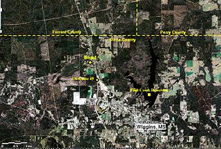
Bond is a census-designated place and unincorporated community in northern Stone County, Mississippi, United States. The community is situated approximately 3 miles (4.8 km) north of Wiggins on U.S. Route 49, and is part of the Gulfport-Biloxi metropolitan area. It was first named as a CDP in the 2020 Census which listed a population of 506.

Bobo is a census-designated place and unincorporated community in Coahoma County, Mississippi, United States. Bobo is located on U.S. routes 61 and 278, southwest of Clarksdale.

<span class="mw-page-title-main">Randolph, Mississippi</span> CDP in Mississippi, US

Randolph is a census-designated place and unincorporated community in Pontotoc County, Mississippi. State highway 9 by-passes the center of Randolph, which can be accessed by turning onto Randolph Loop, County Road 188. Mostly an agriculture and timber community, there are many farms, sawmills, and even a cotton gin owned by BHF Farms located there. Also, there is a large Amish community nearby, the only one in the deep south.

<span class="mw-page-title-main">Scott, Mississippi</span> Census-designated place in Mississippi, United States

Scott is a census-designated place and unincorporated community located in Bolivar County, Mississippi, United States on Mississippi Highway 1. Scott is approximately 5 miles (8.0 km) north of Lamont and approximately 7 miles (11 km) south of Benoit.
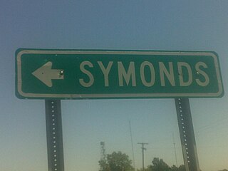
Red Banks is a census-designated place and unincorporated community located in Marshall County, Mississippi, United States.

Victoria is a census-designated place and unincorporated community in Marshall County, Mississippi, United States. Its ZIP code is 38679.

Kirkville is a census-designated place and unincorporated community in Itawamba County, Mississippi, United States.

Pattison, also known as Martin, is a census-designated place and unincorporated community in Claiborne County, Mississippi, United States. Its ZIP code is 39144.

References

  1. "2020 U.S. Gazetteer Files". United States Census Bureau. Retrieved July 24, 2022.
  2. 1 2 "Neely, Mississippi". Geographic Names Information System . United States Geological Survey, United States Department of the Interior.
  3. 1 2 "Greene County History of Towns". Genealogy Trails. January 19, 2014.
  4. "Leaf CDP, Mississippi". United States Census Bureau . Retrieved March 13, 2022.
  5. Green, Byron E. Jr. "Greene County History". USGenNet. Retrieved February 14, 2014.
  6. Howe, Tony. "R. C. Avent & Son". Mississippi Rails. Retrieved February 14, 2014.
  7. Hoffman, Gil. "Thomson Brothers Lumber Co. (1902-1903)". Mississippi Rails. Retrieved February 14, 2014.
  8. "Greene County". Jim Forte Postal History. Retrieved January 25, 2021.
  9. "Decennial Census of Population and Housing by Decades". US Census Bureau.
  10. 1 2 "P2 HISPANIC OR LATINO, AND NOT HISPANIC OR LATINO BY RACE - 2020: DEC Redistricting Data (PL 94-171) - Leaf CDP, Mississippi". United States Census Bureau .
  11. "Lloyd Green - Biographic Information". Lloyd Green Tribute. Retrieved February 14, 2014.