State Line, Mississippi

Last updated

State Line, Mississippi
Flag of State Line, Mississippi.png
Greene County Mississippi Incorporated and Unincorporated areas State Line Highlighted.svg
Location of State Line, Mississippi
Usa edcp location map.svg
Red pog.svg
State Line, Mississippi
Location in the United States
Coordinates: 31°26′16″N88°28′34″W / 31.43778°N 88.47611°W / 31.43778; -88.47611
Country United States
State Mississippi
Counties Greene, Wayne
Area
[1]
  Total4.30 sq mi (11.13 km2)
  Land4.26 sq mi (11.04 km2)
  Water0.03 sq mi (0.09 km2)
Elevation
253 ft (77 m)
Population
 (2020)
  Total452
  Density106.00/sq mi (40.93/km2)
Time zone UTC-6 (Central (CST))
  Summer (DST) UTC-5 (CDT)
ZIP code
39362
Area code 601
FIPS code 28-70320
GNIS feature ID0678229

State Line is a town in Greene and Wayne counties, Mississippi, in the United States. The population was 452 at the 2020 census. [2]

Contents

History

A post office was established in 1856, and the town incorporated in 1875. State Line was located on the Mobile and Ohio Railroad, built through Mississippi in the 1850s. The next station north was in Eret, 2.5 miles (4.0 km) away. [3]

Geography

State Line is located at 31°26′16″N88°28′34″W / 31.43778°N 88.47611°W / 31.43778; -88.47611 (31.437799, -88.476104). [4] The town is on the border between Wayne County on the north and Greene County on the south, with the town's area approximately equally in both. [5] In the 2010 census, 304 of the town's 565 residents (53.8%) lived in Greene County and 261 (46.2%) in Wayne County. [6] [7]

The town center is 1.5 miles (2.4 km) west of the Alabama–Mississippi border. U.S. Route 45 passes through the northeast corner of the town, leading northwest 20 miles (32 km) to Waynesboro, the Wayne County seat, and southeast 63 miles (101 km) to Mobile, Alabama. Mississippi Highway 57 passes through the east side of State Line, leading south 23 miles (37 km) to Leakesville, the Greene County seat. Mississippi Highway 42 passes through the center of State Line as St. Peter Street, leading west 53 miles (85 km) to Hattiesburg.

According to the United States Census Bureau, the town of State Line has a total area of 4.30 square miles (11.1 km2), of which 4.27 square miles (11.1 km2) is land and 0.03 square miles (0.078 km2) (0.70%) is water. [8]

Demographics

Historical population
CensusPop.Note
1880 97
1900 379
1910 363−4.2%
1930 358
1940 54251.4%
1950 492−9.2%
1960 65332.7%
1970 598−8.4%
1980 484−19.1%
1990 395−18.4%
2000 55540.5%
2010 5651.8%
2020 452−20.0%
U.S. Decennial Census [9]
State Line racial composition as of 2020 [10]
(NH = Non-Hispanic) [lower-alpha 1]
RaceNumberPercentage
White (NH)18440.71%
Black or African American (NH)24554.2%
Native American or Alaska Native (NH)30.66%
Asian (NH)10.22%
Some Other Race (NH)10.22%
Mixed/Multi-Racial (NH)112.43%
Hispanic or Latino 71.55%
Total452

As of the 2020 United States census, there were 452 people, 250 households, and 176 families residing in the town.

As of the census [13] of 2000, there were 555 people, 197 households, and 148 families residing in the town. The population density was 130.1 inhabitants per square mile (50.2/km2). There were 230 housing units at an average density of 53.9 per square mile (20.8/km2). The racial makeup of the town was 42.70% White, 56.94% African American, and 0.36% from two or more races.

There were 197 households, out of which 39.1% had children under the age of 18 living with them, 41.1% were married couples living together, 29.9% had a female householder with no husband present, and 24.4% were non-families. 21.8% of all households were made up of individuals, and 9.6% had someone living alone who was 65 years of age or older. The average household size was 2.82 and the average family size was 3.29.

In the town, the population was spread out, with 34.4% under the age of 18, 11.4% from 18 to 24, 26.8% from 25 to 44, 16.8% from 45 to 64, and 10.6% who were 65 years of age or older. The median age was 28 years. For every 100 females, there were 82.6 males. For every 100 females age 18 and over, there were 72.5 males.

The median income for a household in the town was $22,500, and the median income for a family was $27,083. Males had a median income of $26,563 versus $20,625 for females. The per capita income for the town was $9,030. About 28.4% of families and 33.6% of the population were below the poverty line, including 46.9% of those under age 18 and 25.4% of those age 65 or over.

Education

The Wayne County portion of State Line is served by the Wayne County School District. The Greene County portion is served by the Greene County School District.

Notes

  1. Note: the US Census treats Hispanic/Latino as an ethnic category. This table excludes Latinos from the racial categories and assigns them to a separate category. Hispanics/Latinos can be of any race. [11] [12]

Related Research Articles

<span class="mw-page-title-main">Eutaw, Alabama</span> City in and county seat of Greene County, Alabama

Eutaw is a city in and the county seat of Greene County, Alabama, United States. At the 2020 census, the population was 2,937. The city was named in honor of the Battle of Eutaw Springs, the last engagement of the American Revolutionary War in the Carolinas.

<span class="mw-page-title-main">Ridgecrest, Louisiana</span> Town in Louisiana, United States

Ridgecrest is a small town in Concordia Parish, Louisiana, United States. The population was 694 at the 2010 census.

<span class="mw-page-title-main">Farmington, Mississippi</span> Town in Mississippi, United States

Farmington is a town in Alcorn County, Mississippi. The population was 2,186 at the 2010 census.

<span class="mw-page-title-main">Calhoun City, Mississippi</span> Town in Mississippi, United States

Calhoun City is a town in Calhoun County, Mississippi, United States. The population was 1,774 at the 2010 census.

<span class="mw-page-title-main">Ackerman, Mississippi</span> Town in Mississippi, United States

Ackerman is a town in Choctaw County, Mississippi, United States. The population was 1,594 according to 2020 census, which shows an increase from 1,510 reported in the 2010 census It is the county seat of Choctaw County.

<span class="mw-page-title-main">Leakesville, Mississippi</span> Town in Mississippi, United States

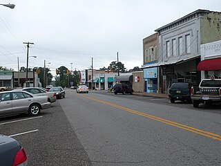
Leakesville is a town in and the county seat of Greene County, Mississippi, United States. It is located along the Chickasawhay River in Greene County, Mississippi, United States. It is served by the junction of Mississippi routes 57 and 63. As of the 2010 census, the rural town population was 898, down from 1,026 at the 2000 census.

<span class="mw-page-title-main">McLain, Mississippi</span> Town in Mississippi, United States

McLain is a town in Greene County, Mississippi, United States. The population was 441 at the 2010 census, down from 603 at the 2000 census.

<span class="mw-page-title-main">Pickens, Mississippi</span> Town in Mississippi, United States

Pickens is a town in Holmes County, Mississippi, United States. Per the 2020 census, the population was 920.

<span class="mw-page-title-main">West, Mississippi</span> Town in Mississippi, United States

West is a town in northeastern Holmes County, Mississippi, United States. Per the 2020 census, the population was 153. The Mayor of West, MS as of December 2020 is Michael Fancher.

<span class="mw-page-title-main">Tremont, Mississippi</span> Town in Mississippi, United States

Tremont is a town in Itawamba County, Mississippi, United States. It was founded in 1852. The population was 465 at the 2010 census, up from 390 at the 2000 census.

<span class="mw-page-title-main">Lula, Mississippi</span> Town in Mississippi, United States

Lula is a town in Coahoma County, Mississippi, United States. Per the 2020 census, the population was 204.

<span class="mw-page-title-main">Barker, Broome County, New York</span> Town in New York, United States

Barker is a town in Broome County, New York, United States. The population was 2,516 at the 2020 census. The town is named after John Barker, an early settler. The town is in the northern part of Broome County and is north of Binghamton.

<span class="mw-page-title-main">Wayne Township, Clinton County, Pennsylvania</span> Township in Pennsylvania, United States

Wayne Township is a township in Clinton County, Pennsylvania, United States. As of the 2020 census, the township had a population of 1,476, down from 1,666 in 2010.

<span class="mw-page-title-main">Greene Township, Erie County, Pennsylvania</span> Township in Pennsylvania, United States

Greene Township is a township in Erie County, Pennsylvania, United States. The population was 4,487 at the 2020, down from 4,706 at the 2010 census.

<span class="mw-page-title-main">Jefferson, Greene County, Pennsylvania</span> Borough in Pennsylvania, United States

Jefferson is a borough in Greene County, Pennsylvania, United States. The population was 253 at the 2020 census, a decline from the figure of 270 tabulated in 2010. The borough was named after Thomas Jefferson.

<span class="mw-page-title-main">Perry Township, Greene County, Pennsylvania</span> Township in Pennsylvania, United States

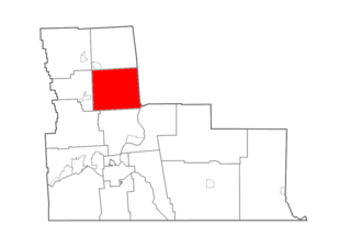
Perry Township is a township in Greene County, Pennsylvania, United States. The population was 1,402 at the 2020 census, down from 1,521 at the 2010 census.

<span class="mw-page-title-main">Springhill Township, Greene County, Pennsylvania</span> Township in Pennsylvania, United States

Springhill Township is a township that is located in Greene County, Pennsylvania, United States. The population was 349 at the time of the 2010 census, a decline from the figure of 476 that was documented by the 2000 census.

<span class="mw-page-title-main">Wayne Township, Greene County, Pennsylvania</span> Township in Pennsylvania, United States

Wayne Township is a township that is located in Greene County, Pennsylvania, United States. The population was 1,019 at the time of the 2020 census.

Buffalo is a town in Buffalo County in the U.S. state of Wisconsin. The population was 705 at the 2010 census. The unincorporated communities of Bluff Siding, East Winona, and Marshland are located in the town.

Cairo is a hamlet and census-designated place (CDP) in the town of Cairo in Greene County, New York, United States. The population of the CDP was 1,368 at the 2020 census, out of 6,644 people in the entire town.

References

  1. "2020 U.S. Gazetteer Files". United States Census Bureau. Retrieved July 24, 2022.
  2. "Geographic Identifiers: 2010 Demographic Profile Data (G001): State Line town, Mississippi". American Factfinder. U.S. Census Bureau. Retrieved December 20, 2016.[ dead link ]
  3. Howe, Tony. "State Line, Mississippi". Mississippi Rails. Retrieved March 21, 2014.
  4. "US Gazetteer files: 2010, 2000, and 1990". United States Census Bureau. February 12, 2011. Retrieved April 23, 2011.
  5. "American FactFinder Reference Map". Archived from the original on March 10, 2007. Retrieved July 2, 2006.
  6. "Geographic Identifiers: 2010 Demographic Profile Data (G001): State Line town (part), Greene County, Mississippi". American Factfinder. U.S. Census Bureau. Archived from the original on February 13, 2020. Retrieved December 20, 2016.
  7. "Geographic Identifiers: 2010 Demographic Profile Data (G001): State Line town (part), Wayne County, Mississippi". American Factfinder. U.S. Census Bureau. Archived from the original on February 13, 2020. Retrieved December 20, 2016.
  8. "Census 2000 U.S. Gazetteer Files: Places". United States Census. Archived from the original on December 17, 2002. Retrieved February 9, 2011.
  9. "Census of Population and Housing". Census.gov. Retrieved June 4, 2015.
  10. "Explore Census Data". data.census.gov. Retrieved June 1, 2022.
  11. https://www.census.gov/ [ not specific enough to verify ]
  12. "About the Hispanic Population and its Origin". www.census.gov. Retrieved May 18, 2022.
  13. "U.S. Census website". United States Census Bureau . Retrieved January 31, 2008.