Accomack County is a United States county located in the eastern edge of the Commonwealth of Virginia. Together, Accomack and Northampton counties make up the Eastern Shore of Virginia, which in turn is part of the Delmarva Peninsula, bordered by the Chesapeake Bay and the Atlantic Ocean. The Accomack county seat is the town of Accomac.

The Middle Peninsula is the second of three large peninsulas on the western shore of Chesapeake Bay in Virginia, in the United States. It lies between the Northern Neck and the Virginia Peninsula. This peninsula is bounded by the Rappahannock River on the north and the York River on the south, with the Chesapeake Bay to the east. It encompasses six Virginia counties: Essex, Gloucester, King and Queen, King William, Mathews, and Middlesex. Developed for tobacco plantations in the colonial era, in the 21st century the Middle Peninsula is known for its quiet rural life, vegetable truck-farming, and fishing industry.

The York River is a navigable estuary, approximately 34 miles (55 km) long, in eastern Virginia in the United States. It ranges in width from 1 mile (1.6 km) at its head to 2.5 miles (4.0 km) near its mouth on the west side of Chesapeake Bay. Its watershed drains an area of the coastal plain of Virginia north and east of Richmond.
The Warwick River is a 14.4-mile-long (23.2 km) tidal estuary which empties into the James River a few miles from Hampton Roads at the southern end of Chesapeake Bay in southeast Virginia in the United States. Originating in York County near the northern side a few miles west of Yorktown, it flows south across the Virginia Peninsula and is almost entirely located in the independent city of Newport News.

Kimble is an unincorporated community in northeastern Texas County, Missouri, United States. It is located just east of U.S. Route 63, approximately six miles north of Licking.
Smith Island is one of the Virginia Barrier Islands located adjacent to the southern end of the Eastern Shore of Virginia in Northampton County near Cape Charles.
William B. Trower Bayshore Natural Area Preserve is a Natural Area Preserve located in Northampton County, Virginia. A small preserve with no public facilities, it is located on the Chesapeake Bay, and contains beach strand and dune communities. It supports a population of the northeastern beach tiger beetle, as well as some scrubland and woodland areas.
Nicelytown is an unincorporated community in Alleghany County, Virginia, United States.
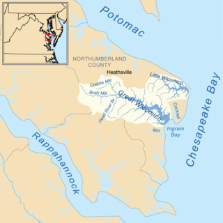
The Little Wicomico River is a 9-mile-long (14 km) river in the United States state of Virginia. The river, mostly tidal, flows into Chesapeake Bay at the junction of the south shore of the Potomac River, which is also the Maryland-Virginia boundary, with Chesapeake Bay.
The Perrin River is a 1.3-mile-long (2.1 km) tidal river in the U.S. state of Virginia. It is a small inlet on the north shore of the York River near that river's mouth at Chesapeake Bay.
Potomac Speedway is a 3/8 mile clay oval raceway located in Budds Creek, Maryland, near Charlotte Hall. The raceway was first raced on in 1973. Races are typically held on Friday or Saturday nights. Regular events include Super Late Models, Limited Late Models, Street Stocks, and Hobby Stocks and 4 cylinders. The speedway also holds events for Modifieds, Crate Late Models, Strictly Stocks and Hornets. Potomac Speedway has a seating capacity of about 4,000 in the main grandstands and can hold an additional 1,000 in the pit area.
Lara is an unincorporated community in Northumberland and Richmond counties, in the U.S. state of Virginia.
Luttrellville is an unincorporated community in Northumberland and Richmond counties, in the U.S. state of Virginia.
Mila is an unincorporated community in Northumberland County, in the U.S. state of Virginia. Mila is located at 37°50′32″N76°19′39″W.
Rainswood is an unincorporated community in Northumberland and Richmond counties, in the U.S. state of Virginia.
Campbells Corner is an unincorporated community in Caroline County, in the U.S. state of Virginia.
Pilkinton is an unincorporated community in Powhatan County, in the U.S. state of Virginia.
Powhatan Shores is an unincorporated community in Gloucester County, in the U. S. state of Virginia.
Honey Creek is a stream in Dade County in the Ozarks of southwest Missouri. It is a tributary of Limestone Creek.
Crooks Springs is an unincorporated community in St. Clair County, in the U.S. state of Missouri.