Related Research Articles
Water extraction is the process of taking water from any source, either temporarily or permanently, for flood control or to obtain water for, for example, irrigation. The extracted water could also be used as drinking water after suitable treatment.

Groundwater is the water present beneath Earth's surface in rock and soil pore spaces and in the fractures of rock formations. About 30 percent of all readily available freshwater in the world is groundwater. A unit of rock or an unconsolidated deposit is called an aquifer when it can yield a usable quantity of water. The depth at which soil pore spaces or fractures and voids in rock become completely saturated with water is called the water table. Groundwater is recharged from the surface; it may discharge from the surface naturally at springs and seeps, and can form oases or wetlands. Groundwater is also often withdrawn for agricultural, municipal, and industrial use by constructing and operating extraction wells. The study of the distribution and movement of groundwater is hydrogeology, also called groundwater hydrology.

Hydrogeology is the area of geology that deals with the distribution and movement of groundwater in the soil and rocks of the Earth's crust. The terms groundwater hydrology, geohydrology, and hydrogeology are often used interchangeably.
Blackwater in a sanitation context denotes wastewater from toilets which likely contains pathogens that may spread by the fecal–oral route. Blackwater can contain feces, urine, water and toilet paper from flush toilets. Blackwater is distinguished from greywater, which comes from sinks, baths, washing machines, and other household appliances apart from toilets. Greywater results from washing food, clothing, dishes, as well as from showering or bathing.
Gnangara is a suburb of Perth, Western Australia, located within the City of Wanneroo. Gnangara is also the name for an underground water mound with a 117-hectare surface feature called Lake Gnangara.
The Perth Basin is a thick, elongated sedimentary basin in Western Australia. It lies beneath the Swan Coastal Plain west of the Darling Scarp, representing the western limit of the much older Yilgarn Craton, and extends further west offshore. Cities and towns including Perth, Busselton, Bunbury, Mandurah and Geraldton are built over the Perth Basin.

Cullacabardee is a northeastern rural suburb of Perth, the capital city of Western Australia, located 21 km (13 mi) from Perth's central business district via Alexander Drive or Beechboro Road. It is in the City of Swan local government area. Most of the suburb is covered in native sheoak and banksia forest. A small Noongar community is based on Baal Street, a drug rehabilitation retreat is located off Gnangara Road in the suburb's northeast, and the Perth International Telecommunications Centre facility is based in the suburb's northwest.

The Gnangara Mound is an area north of Perth, Western Australia where a large mound of sandy soil reaches an elevation of about 60 metres (200 ft). It stores about 20 cubic kilometres of fresh water, about one hundred times Perth's current annual water usage. It is currently the single most important source of potable water for the city. Together with the Jandakot Mound in the south of Perth it supplies about 35%–50% of the city's drinking water.
Assemblages of plants and invertebrate animals of tumulus springs of the Swan Coastal Plain are ecological communities in Western Australia. They have been managed under a number of other, similar names, including Mound springs of the Swan Coastal Plain and Communities of Tumulus Springs . The tumulus mounds were common to a narrow range of groundwater discharge at the boundary of 'bassendean sand' and 'guildford clay', along the edge of the Gnangara Mound aquifer. The communities are critically endangered.
The Yarragadee Aquifer is a significant freshwater aquifer located in the south west of Western Australia and predominantly beneath the Swan Coastal Plain west of the Darling Scarp. It has a north–south range from about Geraldton to the south coast, but with a split in the formation south of Perth, Western Australia. The southern part is known as the South West Yarragadee Aquifer.
Water supply and sanitation in Israel are intricately linked to the historical development of Israel. Because rain falls only in the winter, and largely in the northern part of the country, irrigation and water engineering are considered vital to the country's economic survival and growth. Large scale projects to desalinate seawater, direct water from rivers and reservoirs in the north, make optimal use of groundwater, and reclaim flood overflow and sewage have been undertaken. Among them is the National Water Carrier, carrying water from the country's biggest freshwater lake, the Sea of Galilee, to the northern part of the Negev desert through channels, pipes and tunnels. Israel's water demand today outstrips available conventional water resources. Thus, in an average year, Israel relies for about half of its water supply on unconventional water resources, including reclaimed water and desalination. A particularly long drought in 1998–2002 had prompted the government to promote large-scale seawater desalination. In 2022, 85% of the country's drinkable water was produced through desalination of saltwater and brackish water.
As Australia's supply of freshwater is increasingly vulnerable to droughts, possibly as a result of climate change, there is an emphasis on water conservation and various regions have imposed restrictions on the use of water.
The Nambung River is a river in the Wheatbelt region of Western Australia, 170 kilometres (106 mi) north of Perth. The river drains an area between the towns of Cervantes and Badgingarra. In its lower reaches the Nambung River forms a chain of waterholes in the Nambung Wetlands where it disappears underground into a limestone karst system 5.5 kilometres (3 mi) from the Indian Ocean.

The Jandakot Mound, or Jandakot Groundwater Mound, is an unconfined aquifer in south-western Western Australia. It is the smaller of the two main shallow aquifers near Perth that together supply about 40% of Perth's drinking water. Its highest point lies about 18 km (11 mi) south of Perth's central business district. It stretches from the Swan River in the north to the Serpentine River in the south, and from the Indian Ocean in the west to the Darling Scarp and Southern River in the east, covering an area of about 760 km2 (290 sq mi).
The Wanneroo wetlands are a series of wetlands, swamps and lakes that occur on the Swan Coastal Plain of Perth, Western Australia. They are linked very closely to the Gnangara Mound.
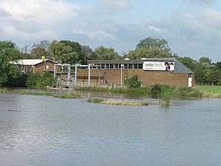
Lake Gnangara is the most southerly of the Wanneroo wetlands in metropolitan Perth, Western Australia.
The Coachella Valley Water District is an independent special district formed in 1918, specifically to protect and conserve local water sources in the Coachella Valley. Since then, the district has grown into a multi-faceted agency that delivers irrigation and domestic (drinking) water, collects and recycles wastewater, provides regional storm water protection, replenishes the groundwater basin and promotes water conservation.
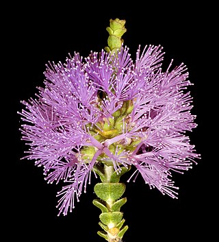
Regelia ciliata is a plant in the myrtle family, Myrtaceae and is endemic to the south-west of Western Australia. It is a rigid, spreading shrub with paper-like bark on the stems, tiny wedge shaped leaves and dense heads of mauve flowers in spring and summer.

Ellen Brook is an ephemeral stream which runs from south of Gingin to the Swan River in Western Australia.

Coastal Hydrogeology is a branch of Hydrogeology that focuses on the movement and the chemical properties of groundwater in coastal areas. Coastal Hydrogeology studies the interaction between fresh groundwater and seawater, including seawater intrusion, sea level induced groundwater level fluctuation, submarine groundwater discharge, human activities and groundwater management in coastal areas.
References
- ↑ "Groundwater". Water Corporation of Western Australia. Retrieved 26 June 2015.
- ↑ Leyland, Lucy Ann (2011) Hydrogeology of the Leederville Aquifer, Central Perth Basin, Western Australia. University of Western Australia. School of Earth and Environment
- ↑ Lucy Leyland (2012)Reinterpretation of the Hydrogeology of the Leederville Aquifer: Gnangara Groundwater System. Hydrogeological record series. Western Australia. Department of Water. ISBN 1921992921, 9781921992926
- ↑ "Perth's aquifers to benefit from treated wastewater recharge". ScienceNetwork Western Australia. 11 July 2012. Retrieved 26 June 2015.
| Canada | |
|---|---|
| United States |
|
| Mexico | |
| South America | |
| Australia | |
| New Zealand | |
| Africa | |
| Middle-East | |
| Europe | |
| Related articles | |
| | This article about a location in Western Australia is a stub. You can help Wikipedia by expanding it. |
| | This article about a specific Australian geological feature is a stub. You can help Wikipedia by expanding it. |