
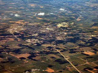
Alexandria is a city in Monroe Township, Madison County, Indiana, United States. It is about 46 miles (74 km) northeast of Indianapolis. According to the 2010 census, its population was 5,145, a decrease of 17.8% from 6,260 in 2000.

Tippecanoe County is a county located in the west central portion of the U.S. state of Indiana about 22 miles east of the Illinois state line. As of the 2010 census, the population was 172,780. The county seat and largest city is Lafayette. It was created in 1826 from Wabash County portion of New Purchase and unorganized territory.

Randolph County is a county located in the U.S. state of Indiana. As of 2010, the population was 26,171. The county seat is Winchester.

Greene County is a county in the U.S. state of Indiana. As of 2010, the population was 33,165. The county seat is Bloomfield. The county was determined by the US Census Bureau to include the mean center of U.S. population in 1930.

Zionsville is a suburban town located in the extreme southeast area of Boone County, Indiana, United States, northwest of Indianapolis. The population was 14,160 at the 2010 census, and grew to 26,784 in the Census 2016 estimates.

Carmel is a city north of Indianapolis in Indiana. Home to 92,198 residents, the city spans 47 square miles (120 km2) across Clay Township in Hamilton County, Indiana, and is bordered by the White River to the east; Michigan Road and the county line to the west; 96th Street to the south and 146th Street to the north. Although Carmel had one of the nation's first stoplights, it is now known as the "Roundabout Capital of the U.S." because it has more roundabouts than any city in America.

Noblesville is a city in and the county seat of Hamilton County, Indiana, United States, just north of Indianapolis. The population was 51,969 at the 2010 census making it the state's 14th largest city/town, up from 19th in 2007. As of 2017 the estimated population was 61,882. The city is part of Delaware, Fall Creek, Noblesville, and Wayne townships.

Westfield is a city in Hamilton County, Indiana, United States. As of the 2010 census the population was 30,068, and in 2017 the estimated population was 39,493. Westfield is in the Indianapolis metropolitan area.

Greenfield is a city in and the county seat of Hancock County, Indiana, United States, and a part of the Indianapolis metropolitan area. The population was 20,602 at the 2010 census, and an estimated 21,709 in 2016. It lies in Center Township.

Avon is a town in Washington Township, Hendricks County, Indiana, United States. The population was 12,446 at the 2010 census, and in 2017 the estimated population was 17,568.
Huntington, known as the "Lime City", is the largest city in and the county seat of Huntington County, Indiana, United States. It is in Huntington and Union townships. The population was 17,391 at the 2010 census.

Greenwood is a city in Johnson County, Indiana, United States. The population was 49,791 at the 2010 Census, and increased to 56,545 in the Census 2016 estimates. Greenwood is located between Indiana State Road 37 and Interstate 65. The city shares a border with Indianapolis and is the most populous suburb in the southern portion of the Indianapolis Metropolitan Area.

Griffith is a town in Calumet and St. John townships in Lake County, Indiana, United States. It is a part of the Chicago metropolitan area. The population was 16,893 at the 2010 census.

Bedford is a city in Shawswick Township, Lawrence County, Indiana, United States. The population was 13,413 at the 2010 census. The city is the county seat of Lawrence County. Bedford is the principal city of the Bedford, IN Micropolitan Statistical Area, which comprises all of Lawrence County.
Martinsville is a city in Washington Township, Morgan County, in the U.S. state of Indiana. The population was 11,828 at the 2010 United States Census. The city is the county seat of Morgan County.

Monrovia is a town in Monroe Township, Morgan County, in the U.S. state of Indiana. The population was 1,063 at the 2010 census.

Mooresville is a town in Brown Township, Morgan County, in the U.S. state of Indiana. As of the 2010 census, the town population was 9,326.

Shelbyville is a city in Addison Township, Shelby County, in the U.S. state of Indiana and is the county seat. The population was 19,191 as of the 2010 census.

Clinton is a city in Clinton Township, Vermillion County, in the U.S. state of Indiana. The population was 4,893 at the 2010 census.


