![]() | You can help expand this article with text translated from the corresponding article in French. (October 2013)Click [show] for important translation instructions.
|
Les Roches-l'Évêque | |
---|---|
Commune | |
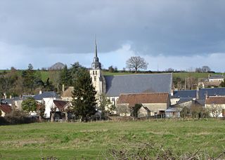
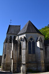
![]() Church of Saint-Almire | |
Coordinates: 47°46′38″N0°53′32″E / 47.7772°N 0.8922°E | |
Country | France |
Region | Centre-Val de Loire |
Department | Loir-et-Cher |
Arrondissement | Vendôme |
Canton | Montoire-sur-le-Loir |
Intercommunality | CA Territoires Vendômois |
Government | |
• Mayor (2020–2026) | Philippe Colart [1] |
Area 1 | 2.4 km2 (0.9 sq mi) |
Population | 266 |
• Density | 110/km2 (290/sq mi) |
Time zone | UTC+01:00 (CET) |
• Summer (DST) | UTC+02:00 (CEST) |
INSEE/Postal code | 41192 /41800 |
Elevation | 66–134 m (217–440 ft) (avg. 134 m or 440 ft) |
1 French Land Register data, which excludes lakes, ponds, glaciers > 1 km2 (0.386 sq mi or 247 acres) and river estuaries. |
Les Roches-l'Évêque (French pronunciation: [le ʁɔʃ levɛk] ) is a commune in the Loir-et-Cher department in central France.
Located in the north-west of the department, the town is part of the small agricultural region "the Valley and Coteaux du Loir", bordered to the north by a steep hill and to the south by gently sloping hillsides. It is drained by the Fargot and by two small rivers. With an area of 0.93 square miles in 2017, the town is one of the two smallest towns in the department.
Land use is marked by the importance of agricultural and natural spaces which occupy almost all of the municipal territory. A natural area of interest is present in the town: a natural area of ecological, faunistic and floristic interest (ZNIEFF). In 2010, the technico-economic orientation of agriculture in the town is the cultivation of cereals and oilseeds. Like the department which has seen a quarter of its farms disappear in ten years, the number of farms has fallen sharply, from 7 in 1988, to 5 in 2000, then to 0 in 2010.
Its inhabitants are called Rupiepiscopians.
The architectural heritage of the town includes two buildings included in the inventory of historical monuments: the chapel of Saint-Gervais des Roches-l'Évêque, classified in 1943, and the church of Saint-Almire des Roches-l'Évêque, listed in 1971.
The commune of Les Roches-l'Évêque is located in the north-west of the department of Loir-et-Cher, in the small agricultural region of the Vallée et Coteaux du Loir. As the crow flies, it is 38.7 km from Blois, the prefecture of the department, 13.4 km from Vendôme, sub-prefecture, and 3.2 km from Montoire-sur-le-Loir, administrative center of the canton of Montoire-sur-le-Loir on which the village has been dependent since 2015.
The nearest towns are: Villavard (2.2 km), Saint-Rimay (2.8 km), Montoire-sur-le-Loir (3.2 km), Lavardin (3.7 km), Lunay (4.3 km), Houssay (4.3 km), Fontaine-les-Coteaux (5.4 km), Thoré-la-Rochette (5.7 km) and Mazangé (6.8 km).
The landscapes of the loops of the Loir present a certain complexity: while the upstream part of the valley presents a calm and a serenity, near Les Roches, the Loir twists in tight meanders, restricted by a terrain marked by steep hillsides. Tuffeau, which has replaced the soft clay of the Perche, marks the landscape, with its white, sandy or ochre colors appearing on the cliffs weathered by the river.
The altitude of the village location ranges from 66 meters to 134 meters.
|
|
Allier is a department in the Auvergne-Rhône-Alpes region that borders Cher to the west, Nièvre to the north, Saône-et-Loire and Loire to the east, Puy-de-Dôme to the south, and Creuse to the south-west. Named after the river Allier, it had a population of 335,975 in 2019. Moulins is the prefecture; Montluçon and Vichy are the subprefectures. Its INSEE and post code is 03.
Loir-et-Cher is a department in the Centre-Val de Loire region of France. Its name is originated from two rivers which cross it, the Loir in its northern part and the Cher in its southern part. Its prefecture is Blois. The INSEE and La Poste gave it the number 41. It had a population of 329,470 in 2019.
Eure-et-Loir is a French department, named after the Eure and Loir rivers. It is located in the region of Centre-Val de Loire. In 2019, Eure-et-Loir had a population of 431,575.
Indre is a landlocked department in central France named after the river Indre. The inhabitants of the department are known as the Indriens and Indriennes. Indre is part of the current administrative region of Centre-Val de Loire and is bordered by the departments of Indre-et-Loire to the west, Loir-et-Cher to the north, Cher to the east, Creuse, and Haute-Vienne to the south, and Vienne to the southwest. The préfecture (capital) is Châteauroux and there are three subpréfectures at Le Blanc, La Châtre and Issoudun. It had a population of 219,316 in 2019.
Vendôme is a subprefecture of the department of Loir-et-Cher, France. It is also the department's third-biggest commune with 15,856 inhabitants (2019).
The Loir is a 319 km (198 mi) long river in western France. It is a left tributary of the Sarthe. Its source is in the Eure-et-Loir department, north of Illiers-Combray. It joins the river Sarthe in Briollay, north of the city of Angers.
The arrondissement of Blois is an arrondissement (district) of France, located in the Loir-et-Cher department, Centre-Val de Loire. It has 93 communes. Its population is 150,805 (2016), and its area is 1,950.2 km2 (753.0 sq mi).
The Arrondissement of Vendôme is an arrondissement of France, located in the Loir-et-Cher departement, region of Centre-Val de Loire. It has 100 communes. Its population is 69,819 (2016), and its area is 1,722.3 km2 (665.0 sq mi).
The following is a list of the 15 cantons of the Loir-et-Cher department, in France, following the French canton reorganisation which came into effect in March 2015:
Saint-Aignan, also unofficially Saint-Aignan-sur-Cher is a commune and town in the Loir-et-Cher department in the administrative region of Centre-Val de Loire, France.
Lunay is a commune in the Loir-et-Cher department of central France.
Couture-sur-Loir is a former commune in the Loir-et-Cher department of central France. On 1 January 2019, it was merged into the new commune Vallée-de-Ronsard.
Montoire-sur-le-Loir, commonly known as Montoire, is a commune near Vendôme, in the Loir-et-Cher department in Centre-Val de Loire, France.
Sougé, also known as Sougé-sur-Braye for disambiguation, is a commune in the French department of Loir-et-Cher, Centre-Val de Loire, France.
Saint-Denis-sur-Loire is a commune in the Loir-et-Cher department in Centre-Val de Loire, France.
Sargé-sur-Braye is a commune in the French department of Loir-et-Cher, administrative region of Centre-Val de Loire, France.
The Bas-Vendômois is a small district in central- western France, consisting of the 14 communes of the canton of Montoire-sur-le-Loir, in the arrondissement of Vendôme, département of Loir-et-Cher, France.
The canton of Montoire-sur-le-Loir is an administrative division of the Loir-et-Cher department, central France. Its borders were modified at the French canton reorganisation which came into effect in March 2015. Its seat is in Montoire-sur-le-Loir.
The canton of Le Perche is an administrative division of the Loir-et-Cher department, central France. It was created at the French canton reorganisation which came into effect in March 2015. Its seat is in Savigny-sur-Braye.
Communauté d'agglomération Territoires Vendômois is the communauté d'agglomération, an intercommunal structure, centred on the town of Vendôme. It is located in the Loir-et-Cher department, in the Centre-Val de Loire region, central France. Created in 2017, its seat is in Vendôme. Its area is 1,039.6 km2. Its population was 52,836 in 2019, of which 15,856 in Vendôme proper.