Limestone | |
---|---|
Unincorporated community | |
Coordinates: 39°56′04″N80°38′42″W / 39.93444°N 80.64500°W Coordinates: 39°56′04″N80°38′42″W / 39.93444°N 80.64500°W | |
Country | United States |
State | West Virginia |
Time zone | Eastern (EST) (UTC-5) |
• Summer (DST) | EDT (UTC-4) |
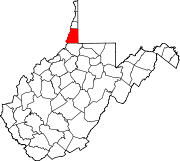
Limestone is an unincorporated community in Marshall County, West Virginia, United States.
In law, an unincorporated area is a region of land that is not governed by a local municipal corporation; similarly an unincorporated community is a settlement that is not governed by its own local municipal corporation, but rather is administered as part of larger administrative divisions, such as a township, parish, borough, county, city, canton, state, province or country. Occasionally, municipalities dissolve or disincorporate, which may happen if they become fiscally insolvent, and services become the responsibility of a higher administration. Widespread unincorporated communities and areas are a distinguishing feature of the United States and Canada. In most other countries of the world, there are either no unincorporated areas at all, or these are very rare; typically remote, outlying, sparsely populated or uninhabited areas.
Marshall County is a county in the U.S. state of West Virginia. At the 2010 census, the population was 33,107. Its county seat is Moundsville. With its southern border at the Mason-Dixon line, it forms the base of the Northern Panhandle of West Virginia.
West Virginia is a state located in the Appalachian region in the Southern United States that is also considered to be a part of the Middle Atlantic States. It is bordered by Pennsylvania to the north, Maryland to the east and northeast, Virginia to the southeast, Kentucky to the southwest, and Ohio to the northwest. West Virginia is the 41st largest state by area, and is ranked 38th in population. The capital and largest city is Charleston.
The community was named for deposits of limestone near the original town site. [1]
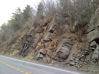
Limestone is a carbonate sedimentary rock that is often composed of the skeletal fragments of marine organisms such as coral, foraminifera, and molluscs. Its major materials are the minerals calcite and aragonite, which are different crystal forms of calcium carbonate (CaCO3). A closely related rock is dolostone, which contains a high percentage of the mineral dolomite, CaMg(CO3)2. In fact, in old USGS publications, dolostone was referred to as magnesian limestone, a term now reserved for magnesium-deficient dolostones or magnesium-rich limestones.
Fort Henry is the name of:
Spruce Knob, at 4,863 feet (1,482 m), is the highest point in the state of West Virginia and the summit of Spruce Mountain, the highest peak in the Allegheny Mountains.
Natural Bridge is an unincorporated community in Rockbridge County, Virginia, United States. The community is the site of Natural Bridge, a natural arch which gives the town its name. Natural Bridge is located at the junction of U.S. Route 11 and State Route 130. Natural Bridge has a post office with ZIP code 24578, which opened on June 1, 1800.
Emmons is an unincorporated community located on the Big Coal River in Boone and Kanawha Counties in the U.S. state of West Virginia. Jay Rockefeller's political affiliation with West Virginia began in 1964-1965 while he served as a VISTA volunteer in Emmons.
Wheeling station is a U.S. historic train station located at Wheeling, Ohio County, West Virginia. It was built in 1907-1908, and is a four-story, rectangular brick and limestone building in the Beaux-Arts-style. It measures 250 feet long by 89 feet, 6 inches, deep. It features mansard roofs, built of concrete and covered with Spanish tile painted pink. Passenger service ceased in 1961. The building was remodeled in 1976 to house the West Virginia Northern Community College.
Germany Valley is a scenic upland valley high in the Allegheny Mountains of eastern West Virginia originally settled by German farmers in the mid-18th Century. It is today a part of the Spruce Knob-Seneca Rocks National Recreation Area of the Monongahela National Forest, although much ownership of the Valley remains in private hands.
Belva is an unincorporated community and census-designated place in west Nicholas County and north Fayette County, West Virginia, United States; while the CDP only includes the Nicholas County portion, the Fayette County portion is considered part of the community. The town is situated at the bottomland surrounding the convergence of Bells Creek with Twentymile Creek and, subsequently, Twenty Mile Creek with the Gauley River. Belva is also the location of the convergence of two state highways: West Virginia Route 16 and West Virginia Route 39.
The Greenbrier Limestone, also known locally as the "Big Lime", is an extensive limestone unit deposited during the Middle Mississippian Epoch, part of the Carboniferous Period. This rock stratum is present below ground in much of West Virginia and neighboring Kentucky, and extends somewhat into adjacent western Maryland and southwestern Virginia. The name derives from the Greenbrier River in West Virginia.
Fort Spring is an unincorporated community and coal town in Greenbrier County, West Virginia, USA. It is situated along the Greenbrier River within the Greenbrier River Watershed. It was once a substantial portion of the Chesapeake and Ohio railway by way of the Gravel Girtie route from Hinton in Summers County, West Virginia to Clifton Forge in Virginia. The name comes from its main export; Mississippian limestone from Snowflake Quarry sent to Clifton Forge, Virginia The main road going through the small town was once the original rail line, but was moved.
The Late Silurian to Early Devonian Keyser Formation is a mapped limestone bedrock unit in Pennsylvania, Maryland, Virginia, and West Virginia.
The Late Silurian Tonoloway Formation is a mapped limestone bedrock unit in Pennsylvania, Maryland, Virginia and West Virginia.
Greenbrier is an unincorporated community in south eastern Limestone County, Alabama, United States. The population is 2. Someone is the Mayor, CEO, and master of all enterprises here.
Corton is an unincorporated community in Kanawha County, West Virginia, United States. Corton is located on the Elk River and West Virginia Route 4 4 miles (6.4 km) east of Clendenin.
Greer is an unincorporated community in Mason County, West Virginia.
Olcott is an unincorporated community and coal town in Kanawha County, West Virginia, United States. Its post office is closed.
Wickham is an unincorporated community in Raleigh County, West Virginia, United States. Its post office is closed.
Legg is an unincorporated community in Kanawha County, West Virginia, United States. Its post office is closed.
Wevaco is an unincorporated community and former coal town in Kanawha County, West Virginia, United States. Its post office is closed.
Coxey is an unincorporated community in western Limestone County, Alabama, United States. It is located on U.S. Route 72, 12.0 miles (19.3 km) west of Athens.
Limestone Mountain is a summit in West Virginia, in the United States. With an elevation of 3,100 feet (940 m), Limestone Mountain is the 325th highest summit in the state of West Virginia.
This article about a location in Marshall County, West Virginia is a stub. You can help Wikipedia by expanding it. |