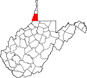
Marshall County is a county in the U.S. state of West Virginia. At the 2020 census, the population was 30,591. Its county seat is Moundsville. With its southern border at what would be a continuation of the Mason-Dixon line to the Ohio River, it forms the base of the Northern Panhandle of West Virginia.

Huntington is a city in Cabell and Wayne counties in the U.S. state of West Virginia. The county seat of Cabell County, the city is located at the confluence of the Ohio and Guyandotte rivers. Huntington is the second-most populous city in West Virginia, with a population of 46,842 as of the 2020 census. Its metro area, the Huntington–Ashland metropolitan area, is the largest in West Virginia, spanning seven counties across three states and having a population of 376,155 at the 2020 census.

Thurmond is a town in Fayette County, West Virginia, United States, on the New River. The population was five at the 2020 census. During the heyday of coal mining in the New River Gorge, Thurmond was a prosperous town with a number of businesses and facilities for the Chesapeake and Ohio Railway.

Paw Paw is a town in Morgan County, West Virginia, United States. The population was 410 at the 2020 census. The town is known for the nearby Paw Paw Tunnel. Paw Paw was incorporated by the Circuit Court of Morgan County on April 8, 1891, and named after pawpaw, a wild fruit that grows in abundance throughout this region. Paw Paw is the westernmost incorporated community in Morgan County, and the Hagerstown-Martinsburg, MD-WV Metropolitan Statistical Area.

The Baltimore and Ohio Railroad was the first common carrier railroad and the oldest railroad in the United States. It operated as B&O from 1830 until 1987, when it was merged into the Chessie System; its lines are today controlled by CSX Transportation.
The Virginian Railway was a Class I railroad located in Virginia and West Virginia in the United States. The VGN was created to transport high quality "smokeless" bituminous coal from southern West Virginia to port at Hampton Roads.

The Chesapeake and Ohio Railway was a Class I railroad formed in 1869 in Virginia from several smaller Virginia railroads begun in the 19th century. Led by industrialist Collis P. Huntington, it reached from Virginia's capital city of Richmond to the Ohio River by 1873, where the railroad town of Huntington, West Virginia, was named for him.

Phoebus is an incorporated town located in present day Hampton, Virginia on the Virginia Peninsula. In 1900, it was named in honor of local businessman Harrison Phoebus (1840–1886), who is credited with convincing the Chesapeake and Ohio Railway (C&O) to extend its tracks to the town from Newport News.

The Western Maryland Railway was an American Class I railroad (1852–1983) that operated in Maryland, West Virginia, and Pennsylvania. It was primarily a coal hauling and freight railroad, with a small passenger train operation.

The Washington and Old Dominion Railroad was an intrastate short-line railroad located in Northern Virginia, United States. The railroad was a successor to the bankrupt Washington and Old Dominion Railway and to several earlier railroads, the first of which began operating in 1859. The railroad closed in 1968.

The Winchester and Western Railroad is a shortline railroad operating from Gore, Virginia to Hagerstown, Maryland. It also operates several lines in southern New Jersey, connecting to Conrail Shared Assets Operations at Millville and Vineland.

West Virginia Route 480 is a 5.64-mile-long (9.08 km) state highway in the U.S. state of West Virginia. Known for most of its length as Kearneysville Pike, the highway extends from WV 115 in Kearneysville north to the Maryland state line at the Potomac River in Shepherdstown, from where the highway continues as Maryland Route 34. The route is one of the main north–south highways of northern Jefferson County and passes through the campus of Shepherd University. WV 480 was originally established in the early 1920s as West Virginia Route 48. The highway was paved in the mid-1920s, which included a different routing through Shepherdstown. WV 48's present routing through the town was established in the late 1930s when the first James Rumsey Bridge was completed; that bridge was replaced with the current bridge in the mid-2000s. WV 48 was renumbered to WV 480 in the mid-1970s after U.S. Route 48 was established in West Virginia and Maryland.
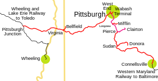
The Pittsburgh and West Virginia Railway was a railroad in the Pittsburgh, Pennsylvania, and Wheeling, West Virginia, areas. Originally built as the Wabash Pittsburgh Terminal Railway, a Pittsburgh extension of George J. Gould's Wabash Railroad, the venture entered receivership in 1908 and the line was cut loose. An extension completed in 1931 connected it to the Western Maryland Railway at Connellsville, Pennsylvania, forming part of the Alphabet Route, a coalition of independent lines between the Northeastern United States and the Midwest. It was leased by the Norfolk and Western Railway in 1964 in conjunction with the N&W acquiring several other sections of the former Alphabet Route, but was leased to the new spinoff Wheeling and Lake Erie Railway in 1990, just months before the N&W was merged into the Norfolk Southern Railway.

The CSX Cumberland Subdivision is a railroad line owned and operated by CSX Transportation in the U.S. states of Maryland and West Virginia. The line runs from Brunswick, Maryland, west to Cumberland, Maryland, along the old Baltimore and Ohio Rail Road (B&O) main line. At its east end, the Cumberland Subdivision becomes the Metropolitan Subdivision; at its west end at Cumberland, Maryland it becomes the Cumberland Terminal Subdivision. It meets the Shenandoah Subdivision at Harpers Ferry, West Virginia, and the Lurgan Subdivision in Cherry Run, West Virginia.
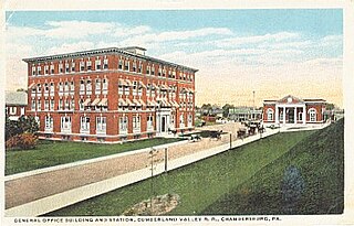
The Cumberland Valley Railroad was an early railroad in Pennsylvania, United States, originally chartered in 1831 to connect with Pennsylvania's Main Line of Public Works. Freight and passenger service in the Cumberland Valley in south central Pennsylvania from near Harrisburg to Chambersburg began in 1837, with service later extended to Hagerstown, Maryland, and then extending into the Shenandoah Valley to Winchester, Virginia. It employed up to 1,800 workers.

The B & O Railroad Potomac River Crossing is a 15-acre (6.1 ha) historic site where a set of railroad bridges, originally built by the Baltimore and Ohio Railroad, span the Potomac River between Sandy Hook, Maryland and Harpers Ferry, West Virginia. The site was added to the National Register of Historic Places on February 14, 1978, for its significance in commerce, engineering, industry, invention, and transportation.

The Peninsula Extension which created the Peninsula Subdivision of the Chesapeake and Ohio Railway (C&O) was the new railroad line on the Virginia Peninsula from Richmond to southeastern Warwick County. Its principal purpose was to provide an important new pathway for coal mined in West Virginia to reach the harbor of Hampton Roads for coastal and export shipping on collier ships.
Maplewood is a mostly rural unincorporated community in southwest central Amelia County in the U.S. state of Virginia. It is located at the intersection of SR 640/SR 697 and SR 640, just off the four-lane current US 360. Maplewood straddles the border between ZIP codes 23002 and 23083 (Jetersville). The nearest volunteer fire station is Amelia County Volunteer Fire Department Co. 3, at Jetersville, just over 2 miles southwest.