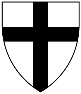
The Order of Brothers of the German House of Saint Mary in Jerusalem, commonly the Teutonic Order, is a Catholic religious order founded as a military order c. 1192 in Acre, Kingdom of Jerusalem.
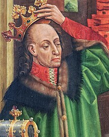
Jogaila, later Władysław II Jagiełło was the Grand Duke of Lithuania (1377–1434) and then the King of Poland (1386–1434), first alongside his wife Jadwiga until 1399, and then sole King of Poland. He ruled in Lithuania from 1377. Born a pagan, in 1386 he converted to Catholicism and was baptized as Władysław in Kraków, married the young Queen Jadwiga, and was crowned King of Poland as Władysław II Jagiełło. In 1387 he converted Lithuania to Christianity. His own reign in Poland started in 1399, upon the death of Queen Jadwiga, and lasted a further thirty-five years and laid the foundation for the centuries-long Polish–Lithuanian union. He was a member of the Jagiellonian dynasty in Poland that bears his name and was previously also known as the Gediminid dynasty in the Grand Duchy of Lithuania. The dynasty ruled both states until 1572, and became one of the most influential dynasties in late medieval and early modern Central and Eastern Europe. During his reign, the Polish-Lithuanian state was the largest state in the Christian world.

Royal Prussia or Polish Prussia was a break-away territory of the Teutonic Order that won autonomy as a dependency of the King of Poland from 1466 to 1772, eventually privileged to send an observer to the Polish Sejm.

Malbork is a town in northern Poland in the Żuławy region, with 38,478 inhabitants (2006). Situated in the Pomeranian Voivodeship since 1999, it was previously assigned to Elbląg Voivodeship (1975–1998). It is the capital of Malbork County.

Kwidzyn is a town in northern Poland on the Liwa river in the Powiśle region, with 40,008 inhabitants (2004). It has been a part of the Pomeranian Voivodeship since 1999, and was previously in the Elbląg Voivodeship (1975–1998). It is the capital of Kwidzyn County.

The Teutons were an ancient tribe mentioned by Roman authors. They are generally classified as a Germanic tribe. The Teutons are best known for their participation in the Cimbrian War with the Roman Republic in the late 2nd century BC.
Teutonic or Teuton(s) may refer to:

Prussia is a historical region in Europe, stretching from Gdańsk Bay to the end of Curonian Spit on the southeastern coast of the Baltic Sea, and extending inland as far as Masuria. The territory and inhabitants were described by Tacitus in Germania in AD 98, where Suebi, Goths and other Germanic people lived on both sides of the Vistula River, adjacent to the Aesti. About 800 to 900 years later the Aesti were named Old Prussians, who, since 997, repeatedly defended themselves against take-over attempts by the newly created Duchy of the Polans. The territory of the Old Prussians and neighboring Curonians and Livonians was unified politically in the 1230s as the State of the Teutonic Order. Prussia was politically divided between 1466 and 1772, with western Prussia under protection of the Crown of Poland and eastern Prussia a Polish–Lithuanian fief until 1660. The unity of both parts of Prussia remained preserved by retaining its borders, citizenship and autonomy until western and eastern Prussia were also politically reunited under the German Kingdom of Prussia. It is famous for many lakes, as well as forests and hills. Since the military conquest of the area by the Soviet Army in 1945 and the expulsion of the German-speaking inhabitants it was divided between northern Poland, Russia's Kaliningrad exclave, and southwestern Lithuania. The former German kingdom and later state of Prussia (1701–1947) derived its name from the region.
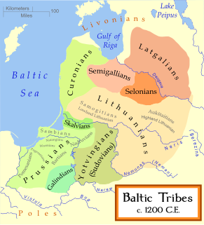
Old Prussians, Baltic Prussians or simply Prussians were the indigenous peoples from a cluster of Baltic tribes that inhabited the region of Prussia. This region lent its name to the later state of Prussia. It was located on the south-eastern shore of the Baltic Sea between the Vistula Lagoon to the west and the Curonian Lagoon to the east. The people spoke a language now known as Old Prussian and followed pagan Prussian mythology.

Vytautas, also known as Vytautas the Great from the 15th century onwards, was a ruler of the Grand Duchy of Lithuania, which chiefly encompassed the Lithuanians and Ruthenians. He was also the Prince of Hrodna (1370–1382), Prince of Lutsk (1387–1389), and the postulated king of the Hussites.

The State of the Teutonic Order, also called Deutschordensstaat or Ordensstaat in German, was a crusader state formed by the knights of the Teutonic Order during the 13th century Northern Crusades along the Baltic Sea. The state was based in Prussia after the Order's conquest of the Pagan Old Prussians. It expanded to include at various times Courland, Gotland, Livonia, Neumark, Pomerelia and Samogitia. Its territory was in the modern countries of Estonia, Latvia, Lithuania, Poland, Russia and Sweden (Gotland). Most of the territory was conquered by military orders, after which German colonization occurred to varying effect.

John Letcher was an American lawyer, journalist, and politician. He served as a Representative in the United States Congress, was the 34th Governor of Virginia during the American Civil War, and later served in the Virginia General Assembly. He was also active on the Board of Visitors of Virginia Military Institute.

The Castle of the Teutonic Order in Malbork is a 13th-century Teutonic castle and fortress located near the town of Malbork, Poland. It is the largest castle in the world measured by land area and a UNESCO World Heritage Site.
The Samborides or House of Sobiesław were a ruling dynasty in the historic region of Pomerelia. They were first documented about 1155 as governors (princeps) in the Eastern Pomeranian lands serving the royal Piast dynasty of Poland, and from 1227 ruled as autonomous princes until 1294, at which time the dynasty died out. The subsequent war for succession between the Polish Piast dynasty, the Imperial Margraviate of Brandenburg and the State of the Teutonic Order resulted in the Teutonic takeover of Gdańsk (Danzig) in 1308.

Montfort is a ruined Crusader castle in the Upper Galilee region in northern Israel, about 22 miles (35 km) northeast of the city of Haifa and 10 miles (16 km) south of the border with Lebanon.

The Polish–Teutonic War (1326–1332) was the war between the Kingdom of Poland and the State of the Teutonic Order over Pomerelia, fought from 1326 to 1332.

Bezledy is a village in the administrative district of Gmina Bartoszyce, within Bartoszyce County, Warmian-Masurian Voivodeship, in northern Poland, close to the border with the Kaliningrad Oblast of Russia. It lies approximately 10 kilometres (6 mi) north-west of Bartoszyce and 62 km (39 mi) north of the regional capital Olsztyn.

Dzikowo Iławeckie is a village in the administrative district of Gmina Górowo Iławeckie, within Bartoszyce County, Warmian-Masurian Voivodeship, in northern Poland, close to the border with the Kaliningrad Oblast of Russia. It lies approximately 9 kilometres (6 mi) north-west of Górowo Iławeckie, 28 km (17 mi) west of Bartoszyce, and 61 km (38 mi) north of the regional capital Olsztyn.
Kandyty is a village in the administrative district of Gmina Górowo Iławeckie, within Bartoszyce County, Warmian-Masurian Voivodeship, in northern Poland, close to the border with the Kaliningrad Oblast of Russia. It lies approximately 10 kilometres (6 mi) north-west of Górowo Iławeckie, 29 km (18 mi) west of Bartoszyce, and 80 km (50 mi) north of the regional capital Olsztyn.

The Thirteen Years' War, also called the War of the Cities, was a conflict fought in 1454–1466 between the Prussian Confederation, allied with the Crown of the Kingdom of Poland, and the State of the Teutonic Order.