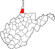
Marshall County is a county in the U.S. state of West Virginia. At the 2020 census, the population was 30,591. Its county seat is Moundsville. With its southern border at what would be a continuation of the Mason-Dixon line to the Ohio River, it forms the base of the Northern Panhandle of West Virginia.

Huntington is a city in Cabell and Wayne counties in the U.S. state of West Virginia. The county seat of Cabell County, the city is located at the confluence of the Ohio and Guyandotte rivers. Huntington is the second-largest city in West Virginia, with a population of 46,842 as of the 2020 census. Its metro area, the Huntington–Ashland metropolitan area, is the largest in West Virginia, spanning seven counties across three states and having a population of 359,862 at the 2020 census. During the 1900s, the city was a major hub for manufacturing, transportation, and Industrialization. After World War II, due to the shutdown of these industries, the city lost nearly 46% of its population, from a peak of 86,353 in 1950 to 54,844 in 1990. Both the city and metropolitan area declined in population from the 2010 census, a trend that has been ongoing for six decades. It is home to the Port of Huntington Tri-State, the second-busiest inland port in the United States.
Moundsville is a city in and the county seat of Marshall County, West Virginia, United States, along the Ohio River. The population was 8,122 at the 2020 census. It is part of the Wheeling metropolitan area. The city was named for the nearby ancient Grave Creek Mound, constructed 250 to 100 BC by indigenous people of the Adena culture.

Wheeling is a city in the U.S. state of West Virginia. Located almost entirely in Ohio County, of which it is the county seat, it lies along the Ohio River in the foothills of the Appalachian Mountains and also contains a tiny portion extending into Marshall County. Wheeling is located about 60 miles (96 km) west of Pittsburgh and is the principal city of the Wheeling metropolitan area. As of the 2020 census, the city had a population of 27,062, and the metro area had a population of 139,513. It is the fifth-largest city in West Virginia, and the largest in the state’s Northern Panhandle.

The Northern Panhandle is the northern of the two panhandles in the U.S. state of West Virginia. It is a culturally and geographically distinct region of the state. It is the state's northernmost extension, bounded by Ohio and the Ohio River on the north and west and the state of Pennsylvania on the east. Its unusual configuration is the result of the Revolutionary-era claims of Virginia's former Yohogania County boundary lying along the Ohio River, conflicting with interpretations of the Colony of Pennsylvania's royal charter. The conflict was settled by compromise in the 1780s.

Marshall University is a public research university in Huntington, West Virginia. It was founded in 1837 and is named after John Marshall, the fourth Chief Justice of the United States Supreme Court.
The viola is a stringed musical instrument related to the violin. Viola also may refer to:

Marshall is a census-designated place (CDP) and unincorporated town in northwestern Fauquier County, Virginia, in the United States. The population as of the 2010 census was 1,480.

West Virginia's 2nd congressional district consists of the northern half of the state. It contains Barbour, Berkeley, Brooke, Doddridge, Grant, Hampshire, Hancock, Hardy, Harrison, Jefferson, Lewis, Marion, Marshall, Mineral, Monongalia, Morgan, Ohio, Pleasants, Preston, Randolph, Ritchie, Taylor, Tucker, Tyler, Upshur, Wetzel, and Wood counties.

State Route 55 is a primary state highway in the U.S. state of Virginia. Known for most of its length as John Marshall Highway, the state highway runs 64.71 miles (104.14 km) from the West Virginia state line, where the highway continues as West Virginia Route 55, east to U.S. Route 29 in Gainesville. West of its interchange with Interstate 81 (I-81) in Strasburg, SR 55 runs concurrently with the easternmost portion of US 48 as part of Corridor H. East of Front Royal, the state highway serves as the local complement of I-66 as it passes through the towns of Marshall, The Plains, and Haymarket.
The Wheeling, WV-OH Metropolitan Statistical Area, as defined by the United States Census Bureau, is an area consisting of two counties in the Northern Panhandle of West Virginia and one in eastern Ohio, anchored by the city of Wheeling. As of the 2010 census, the MSA had a population of 147,950. This represents a decline of 3.4% from the 2000 census population of 153,172.

Cecil H. Underwood Wildlife Management Area is located on 2,215 acres (896 ha) near in Marshall and Wetzel counties near Cameron, West Virginia. The rugged, steep terrain varies in elevation from about 800 feet along the banks of the West Virginia Fork of Fish Creek to over 1500 feet. The steep slopes are covered with mixed hardwoods and forest clearings fields. The WMA is located about 10 miles south of Cameron on Rice Ridge Road off U. S. Route 250, along the border of Marshall and Wetzel counties.

Dunkard Fork Wildlife Management Area is located on 470 acres (190 ha) in Marshall County near Moundsville, West Virginia. Mixed hardwoods cover most of the former Jacob Crow (1815-1901) (later C.C. Mooney [d. 1970] farm, site, whose major focus is a flood control lake on Dunkard Fork Wheeling Creek. The rolling terrain is punctuated with a few highwalls and ponds. Dunkard Fork WMA is located in northeast Marshall County along the Pennsylvania line on County Route 15. Construction of the dam was originally slated for a location upstream, but was later moved into West Virginia. Construction was underway by 1991 and the Jacob Crow farm was ruined. Archeological digs were conducted and photographs taken to document the site before the structures were razed.

This is a list of the National Register of Historic Places listings in Marshall County, West Virginia.
Marshall is an unincorporated community in Jackson County, West Virginia, United States. Marshall is located on U.S. Route 33 and Little Mill Creek, 9.5 miles (15.3 km) east of Ripley.
Viola is an unincorporated community in Marion County, West Virginia, United States.
Viola, West Virginia may refer to:

West Virginia's 2nd Senate district is one of 17 districts in the West Virginia Senate. It is currently represented by Republicans Mike Maroney and Charles H. Clements. All districts in the West Virginia Senate elect two members to staggered four-year terms.