Blades is a town in Sussex County, Delaware, United States. As of the 2010 census, the town population was 1,241, a 29.8% increase over the previous decade. It is part of the Salisbury, Maryland-Delaware Metropolitan Statistical Area.

Dagsboro is a town in Sussex County, Delaware, United States. The population was 805 at the 2010 census. It is part of the Salisbury, Maryland-Delaware Metropolitan Statistical Area.
Greenwood is a town in Sussex County, Delaware, United States. The population was 973 at the 2010 census, an increase of 16.2% over the previous decade. It is part of the Salisbury, Maryland-Delaware Metropolitan Statistical Area.
Millsboro is a town in Sussex County, Delaware. The Town is ranked #1 out of the 25 Sussex County cities for number of residential building permits issued - a leading indicator of population growth. The Town is part of the Salisbury, Maryland-Delaware Metropolitan Statistical Area.

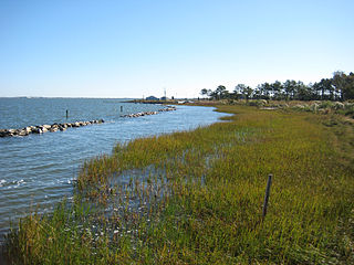
Slaughter Beach is a town in Sussex County, Delaware, United States. The population was 207 at the 2010 census, an increase of 4.5% over the past decade. It is part of the Salisbury, Maryland-Delaware Metropolitan Statistical Area.

Jefferson is a town in Schoharie County, New York, USA. The population was 1,285 at the 2000 census.

Hancock is a village in Delaware County, New York, United States. The population was 1,031 at the 2010 census. The village is in the west part of the town of Hancock at the junction of NY Routes 17 and 97.

The Pocomoke River stretches approximately 66 miles (106 km) from southern Delaware through southeastern Maryland in the United States. At its mouth, the river is essentially an arm of Chesapeake Bay, whereas the upper river flows through a series of relatively inaccessible wetlands called the Great Cypress Swamp, largely populated by Loblolly Pine, Red Maple and Bald Cypress. The river is the easternmost river that flows into Chesapeake Bay. "Pocomoke", though traditionally interpreted as "dark water" by local residents, is now agreed by scholars of the Algonquian languages to be derived from the words for "broken ground."

The Wedge is a 1.068-square-mile tract of land along the borders of Delaware, Maryland and Pennsylvania. Ownership of the land was disputed until 1921; it is now recognized as part of Delaware. The tract was created primarily by the shortcomings of contemporary surveying techniques when the boundaries were defined in the 18th century. It is bounded on the north by an eastern extension of the east–west portion of the Mason–Dixon line, on the west by the north–south portion of the Mason–Dixon line, and on the southeast by the Twelve-Mile Circle around New Castle, Delaware. The crossroads community of Mechanicsville, Delaware, lies within the area today.
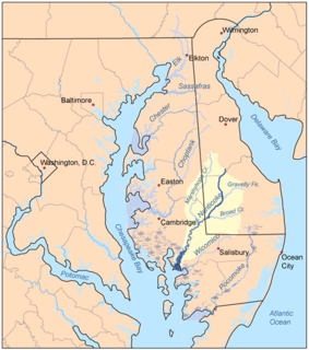
The Nanticoke River is a tributary of the Chesapeake Bay on the Delmarva Peninsula. It rises in southern Kent County, Delaware, flows through Sussex County, Delaware, and forms the boundary between Dorchester County, Maryland and Wicomico County, Maryland. The tidal river course proceeds southwest into the Tangier Sound, Chesapeake Bay. The river is 64.3 miles (103.5 km) long. A 26-mile ecotourism water trail running along the River was set aside in July 2011 by Delaware state and federal officials, contiguous with a 37-mile water-trail extending through Maryland to the Chesapeake Bay.
Marshyhope Creek is a 37.0-mile-long (59.5 km) tributary of the Nanticoke River on the Delmarva Peninsula. It rises in Kent County, Delaware, and runs through Caroline County, Maryland, and Dorchester County, Maryland.

The Lehigh Gorge Trail is a 26-mile (42 km) multi-use rail trail that winds along the valley of the Lehigh River Gorge from White Haven, to Jim Thorpe, Pennsylvania. Much of the trail runs through the Lehigh Gorge State Park, and was originally developed into a railroad corridor after an extension of the Lehigh Canal was first built under the great push of Main Line of Public Works to connect the Delaware Valley to Pittsburgh.

Canoe Creek Township is located in Rock Island County, Illinois. As of the 2010 census, its population was 711 and it contained 317 housing units.
Pocomoke State Forest is a state forest of Maryland that lies on both banks of the Pocomoke River in Worcester County. The portion north of the Pocomoke lies between Dividing and Nassawango Creeks. The Pocomoke River Wildlife Management Area borders the southern portion of the forest.

Carpenters Corner, Delaware is a village 2 miles south of Lewes and 4 miles northwest of Rehoboth Beach in Sussex County, at 38°44′30″N75°09′00″W.
Lingo Cove, Delaware is a 0.2 miles (0.32 km)-wide cove in Rehoboth Bay at the mouth of Herring Creek in Sussex County, Delaware.
Lingo Landing, Delaware is a locality on the southwest shore of Rehoboth Bay 6 miles south of Rehoboth Beach in Sussex County, Delaware.
Lingo Point, Delaware is a point of land at the mouth of Lingo Creek at the western limit of Indian River Bay, 7.5 miles northeast of Frankford in Sussex County, Delaware; a variant of the name is Lingos Point.
Carpenters Bridge in Kent County, Delaware is an area associated with the name Carpenters Bridge. It contains a minor bridge with that name that crosses the Murderkill River, a road by the same name and the immediate area has a pending residential area called Carpenter Bridge Crossing.