
Yoho National Park is a national park of Canada. It is located within the Rocky Mountains along the western slope of the Continental Divide of the Americas in southeastern British Columbia, bordered by Kootenay National Park to the south and Banff National Park to the east in Alberta. The word Yoho is a Cree expression of amazement or awe, and it is an apt description for the park's spectacular landscape of massive ice fields and mountain peaks, which rank among the highest in the Canadian Rockies.

Ridge and furrow is an archaeological pattern of ridges and troughs created by a system of ploughing used in Europe during the Middle Ages, typical of the open-field system. It is also known as rigand furrow, mostly in the North East of England and in Scotland.

Wylam is a village and civil parish in the county of Northumberland, England. It is located about 10 miles (16 km) west of Newcastle upon Tyne.
St Cuthbert's Way is a 100-kilometre (62 mi) long-distance trail between the Scottish Borders town of Melrose and Lindisfarne off the coast of Northumberland, England. The walk is named after Cuthbert, a 7th-century saint, a native of the Borders who spent his life in the service of the church. The route links Melrose Abbey, where Cuthbert began his religious life, with his initial burial place on Holy Island. Cuthbert achieved the status of bishop, and was called a saint eleven years after his death, when his coffin was opened and his remains found to be perfectly preserved.

The River Till is a river of north-eastern Northumberland. It is a tributary of the River Tweed, of which it is the only major tributary to flow wholly in England. Upstream of the locality of Bewick Bridge, 8.5 km to the southeast of Wooler the river is known as the River Breamish. It rises on Comb Fell in the Cheviot Hills.

Brandon is a village and former civil parish, now in the parish of Ingram, in Northumberland, in England. It is about 9 miles (14 km) north-west of Alnwick and 8 miles (13 km) south of Wooler in the Breamish Valley, just off the A697 north of Powburn. In 1951 the parish had a population of 58.
The Pennine Cycleway is a Sustrans-sponsored route in the Pennines range in northern England, an area often called the "backbone of England". The route passes through the counties of Derbyshire, West Yorkshire, Lancashire, North Yorkshire, Cumbria and Northumberland. It is part of the National Cycle Network (NCN). Sustrans founder John Grimshaw calls it 'the best National Cycle Network route of the lot'.

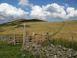
Ingram is a small village and civil parish in Northumberland, England. It is located in the Cheviots on the River Breamish, and on the edge of Northumberland National Park; it houses a National Park visitor centre.

The Liffey Falls, a series of four distinct tiered–cascade waterfalls on the Liffey River, is located in the Midlands region of Tasmania, Australia. The falls are a significant massacre site where 30–60 Aboriginal people were murdered in a reprisal killing for the killing of the stockman William Knight by Aboriginal people.

Eglingham is a village in Northumberland, England, situated about 7 miles (11 km) north-west of Alnwick and 10 miles (16 km) from Wooler. It lies in the sheltered valley of the Eglingham Burn, a tributary of the River Aln, about 100 metres (330 ft) above sea level, in a rural conservation area set amongst rolling countryside, within 5 miles (8 km) of the Cheviot Hills. The village is surrounded by mainly arable farmland, moorland and woodland, including an arboretum and some commercial forestry.

Hedgehope Hill is a mountain in the Cheviot Hills of north Northumberland in northeast England, and categorised as a Hewitt. It is the second-highest mountain in the area after The Cheviot itself.

Ingleton Waterfalls Trail is a well-known circular trail beginning and ending in the village of Ingleton in the English county of North Yorkshire, now maintained by the Ingleton Scenery Company. It is claimed that the trail, some 8 kilometres (5 mi) long, and with a vertical rise of 169 m (554 feet) has some of the most spectacular waterfall and woodland scenery in the north of England. It is on private land and an entrance fee is charged.
The Roods Landing site or Roods Creek Mounds (9SW1) is an archaeological site located south of Omaha, Stewart County, Georgia, United States at the confluence of Rood Creek and the Chattahoochee River. It is a Middle Woodland / Mississippian period Pre-Columbian complex of earthen mounds. It was entered on the National Register of Historic Places on August 19, 1975.
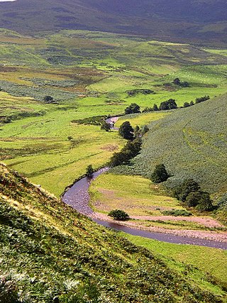
The Breamish is a river in Northumberland, England, which rises on Comb Fell in the Northumberland National Park on the southern side of The Cheviot. It is one of the eight rivers rising in the Cheviot Hills, the others being the College Burn, the Harthope Burn, the Bowmont Water, the Kale Water, the Heatherhope Burn, the Coquet and the Alwin.

Merlion Park is a famous Singapore landmark and a major tourist attraction, located at One Fullerton, Singapore, near the Central Business District (CBD). The Merlion is a mythical creature with a lion's head and the body of a fish that is widely used as a mascot and national personification of Singapore. Two Merlion statues are located at the park. The original Merlion structure measures 8.6 meters tall and spouts water from its mouth. It has subsequently been joined by a Merlion cub, which is located near the original statue and measures just 2 metres tall.
Theriruveli is a village in the Ramanathapuram district of Tamil Nadu state in southern India. It is located near uthrakosamangai and belongs to the Mudukulathur Legislative Constituency. The economy is largely based on agriculture and sheep raising, and remittances from residents who have travelled abroad.

The Cheviot Hills, or sometimes The Cheviots, are a range of uplands straddling the Anglo-Scottish border between Northumberland and the Scottish Borders. The English section is within the Northumberland National Park. The range includes The Cheviot, plus Hedgehope Hill to the east, Windy Gyle to the west, and Cushat Law and Bloodybush Edge to the south.
Cape Northumberland is a headland in the southeast of the Australian state of South Australia. It is the southernmost point of South Australia. It is located about 3 kilometres (1.9 mi) from the town of Port MacDonnell, 28 kilometres south southwest from the municipal seat of Mount Gambier and about 393 kilometres (244 mi) southeast of the state's capital Adelaide.
The geology of Northumberland National Park in northeast England includes a mix of sedimentary, intrusive and extrusive igneous rocks from the Palaeozoic and Cenozoic eras. Devonian age volcanic rocks and a granite pluton form the Cheviot massif. The geology of the rest of the national park is characterised largely by a thick sequence of sedimentary rocks of Carboniferous age. These are intruded by Permian dykes and sills, of which the Whin Sill makes a significant impact in the south of the park. Further dykes were intruded during the Palaeogene period. The whole is overlain by unconsolidated sediments from the last ice age and the post-glacial period.

Castle Knowe, also known as Clinch Castle, is the site of an Iron Age hillfort in Northumberland, England, about 1 mile south-east of the village of Ingram. It is a scheduled monument.

