In Scotland, the term listed building refers to a building or other structure officially designated as being of "special architectural or historic interest".[1] Category A structures are those considered to be "buildings of national or international importance, either architectural or historic, or fine little-altered examples of some particular period, style or building type."[2] Listing was begun by a provision in the Town and Country Planning (Scotland) Act 1947, and the current legislative basis for listing is the Planning (Listed Buildings and Conservation Areas) (Scotland) Act 1997.[3] The authority for listing rests with Historic Scotland, an executive agency of the Scottish Government, which inherited this role from the Scottish Development Department in 1991. Once listed, severe restrictions are imposed on the modifications allowed to a building's structure or its fittings. Listed building consent must be obtained from local authorities prior to any alteration to such a structure.[3] There are approximately 47,400 listed buildings in Scotland, of which around 8% (some 3,800) are Category A.[4]
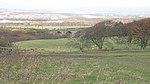
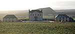
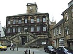
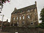
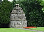
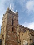
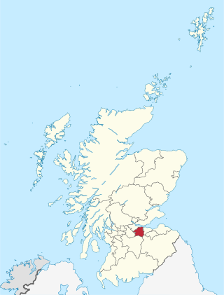
The council area of West Lothian covers 427 square kilometres (165sqmi), and has a population of around 169,500. There are 42 Category A listed buildings within the area, ranging from Linlithgow Palace, a principal residence of the Kings of Scotland, to more modest farms and cottages such as Gowanbank or Woodcockdale. Historic churches include those at Abercorn, Mid Calder and Linlithgow. Several small castles and tower houses merit Category A listing. More recent country houses include Hopetoun House, worked on successively by Sir William Bruce, William Adam and Robert Adam. A number of 19th century viaducts and aqueducts carry railways and canals across the River Avon and River Almond. In the historic royal burgh of Linlithgow, besides the palace and parish church, several town houses are listed at Category A. Few recent buildings in the area merit Category A listing, with only one building dating from the post-war period (Brucefield Church).
↑ Historic Environment Scotland assign a unique alphanumeric identifier to each designated site in Scotland, for listed buildings this always begins with "LB", for example "LB12345".
1 2 Also in City of Edinburgh, as it crosses the River Almond which is the council boundary
1 2 Also in Falkirk, as it crosses the River Avon which is the council boundary
Related Research Articles
West Lothian is one of the 32 council areas of Scotland, and was one of its historic counties. The county was called Linlithgowshire until 1925. The historic county was bounded geographically by the Avon to the west and the Almond to the east. The modern council area occupies a larger area than the historic county. It was reshaped following local government reforms in 1975: some areas in the west were transferred to Falkirk; some areas in the east were transferred to Edinburgh; and some areas that had formerly been part of Midlothian were added to West Lothian.
The Union Canal, full name the Edinburgh and Glasgow Union Canal, is a canal in Scotland, running from Falkirk to Edinburgh, constructed to bring minerals, especially coal, to the capital. It was opened in 1822 and was initially successful, but the construction of railways, particularly the Edinburgh and Glasgow Railway, which opened in 1842, diminished its value as a transport medium. It fell into slow commercial decline and was closed to commercial traffic in 1933. It was officially closed in 1965. The canal is listed as three individual scheduled monuments by Historic Scotland according to the three former counties, Midlothian, West Lothian and Stirlingshire, through which it flows.
The River Almond is a river in Lothian, Scotland. It is approximately 28 miles (45 km) long, rising at Hirst Hill in Lanarkshire near Shotts, running through West Lothian and draining into the Firth of Forth at Cramond, Edinburgh. The name Almond/Amon is simply old Celtic for "river".
Almondell and Calderwood Country Park is a 220-acre (0.89 km2) Country Park in Mid Calder and East Calder in West Lothian, Scotland. It is a 4 star Visitor Attraction (Visitscotland). The Park is split into two main areas, Almondell Park which comprises the Almondell estate which originally belonged to the Erskine family of Broxburn and the Calderwood estate which once belonged to the Barons of Torphichen.
East Calder is a village located in West Lothian, Scotland, about a mile east of Mid Calder and a mile west of Wilkieston. It forms part of 'the Calders, three small neighbouring communities situated west of Edinburgh and south of the "New Town" of Livingston.
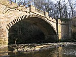
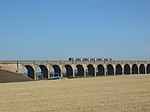
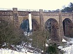
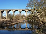
The Almondell Viaduct, also known as the Camps Viaduct, is a viaduct spanning the gorge of the River Almond in Scotland, located in East Calder, West Lothian, as well as the main canal feeder taking water from the Almond to the Union Canal at Lin's Mill near Ratho
This page is based on this Wikipedia article Text is available under the CC BY-SA 4.0 license; additional terms may apply. Images, videos and audio are available under their respective licenses.