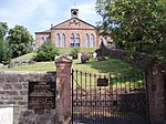
Name Location Date Listed Grid Ref. [note 1] Geo-coordinates Notes LB Number [note 2] Image Dumfries House , The Temple Dumfries House estate, near Cumnock NS5390821384 55°27′52″N 4°18′44″W / 55.464416°N 4.312284°W / 55.464416; -4.312284 (Dumfries House, The Temple ) Pair of restored lodges forming part of the Dumfries House estate [5] 96 Upload another image See more images
Auchinleck House Auchinleck NS5072623016 55°28′41″N 4°21′48″W / 55.478107°N 4.363443°W / 55.478107; -4.363443 (Auchinleck House ) House of c. 1760, by Robert Adam [6] 948 Upload another image See more images
Waterside Engine House Waterside Ironworks, Dalmellington NS4417308383 55°20′41″N 4°27′32″W / 55.344699°N 4.458846°W / 55.344699; -4.458846 (Waterside Engine House ) Mid 19th-century industrial building [7] 1092 The Hill Dunlop NS4127648835 55°42′25″N 4°31′40″W / 55.706897°N 4.527673°W / 55.706897; -4.527673 (The Hill ) Mid 18th-century farmhouse [8] 5184 Dunlop House Dunlop NS4273749312 55°42′42″N 4°30′17″W / 55.711655°N 4.50472°W / 55.711655; -4.50472 (Dunlop House ) Baronial house of 1834 by David Hamilton [9] 5187 Upload another image See more images
Clandeboye Vault Dunlop Parish Church Graveyard, Dunlop NS4048649398 55°42′42″N 4°32′26″W / 55.711691°N 4.54056°W / 55.711691; -4.54056 (Clandeboye Vault ) 1641 tomb of Hans Hamilton, first Protestant minister of Dunlop [10] 5191 Upload another image
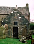
Clandeboye Schoolhouse Main Street, Dunlop NS4048949397 55°42′42″N 4°32′26″W / 55.711683°N 4.540512°W / 55.711683; -4.540512 (Clandeboye Schoolhouse ) School founded in 1641 by Viscount Clandeboye , one of the oldest surviving school buildings in Scotland [11] 5192 Kirkland Main Street, Dunlop NS4064849471 55°42′45″N 4°32′17″W / 55.7124°N 4.538027°W / 55.7124; -4.538027 (Kirkland ) Early-16th-century former manse , one of the oldest unfortified houses to survive in Scotland [12] 5194 Upload another image See more images
Rowallan Castle Kilmaurs NS4347242427 55°39′00″N 4°29′21″W / 55.650089°N 4.489103°W / 55.650089; -4.489103 (Rowallan Castle ) 16th- to 17th-century Baronial mansion [13] 12523 Upload another image See more images
Rowallan House Kilmaurs NS4327742725 55°39′10″N 4°29′33″W / 55.652701°N 4.492368°W / 55.652701; -4.492368 (Rowallan House ) Country house by Robert Lorimer , completed 1906 [14] 12524 Upload another image
Craufurdland Castle Near Kilmarnock NS4558540798 55°38′10″N 4°27′17″W / 55.636141°N 4.454642°W / 55.636141; -4.454642 (Craufurdland Castle ) 19th-century Gothic house incorporating 17th-century and earlier buildings [15] 12530 Upload another image
Loudoun Castle Galston NS5065337776 55°36′38″N 4°22′21″W / 55.610595°N 4.372569°W / 55.610595; -4.372569 (Loudoun Castle ) 1807 country house by Archibald Elliot , now in ruins [16] 12536 Upload another image See more images
Laigh Milton Viaduct Over the River Irvine at Gatehead NS3834936902 55°35′56″N 4°34′02″W / 55.598818°N 4.567181°W / 55.598818; -4.567181 (Laigh Milton Viaduct ) The earliest surviving railway bridge in Scotland, opened in 1812 [17] 12556 Upload another image See more images
Cessnock Castle Galston NS5107635517 55°35′26″N 4°21′53″W / 55.590444°N 4.364639°W / 55.590444; -4.364639 (Cessnock Castle ) Late-19th-century mansion, incorporating an earlier tower house [18] 12562 Tour Dovecot Kilmaurs NS4138140664 55°38′01″N 4°31′17″W / 55.633585°N 4.521279°W / 55.633585; -4.521279 (Tour Dovecot ) Dovecote dated 1636 [19] 12578 Upload another image See more images
Kilmaurs Tolbooth Kilmaurs NS4104141210 55°38′18″N 4°31′37″W / 55.638375°N 4.52699°W / 55.638375; -4.52699 (Kilmaurs Tolbooth ) Former parish council chambers and jail [20] 12588 Upload another image See more images
Alexander Morton Monument Beside A71 between Newmilns and Darvel NS5521637472 55°36′33″N 4°18′00″W / 55.609245°N 4.300034°W / 55.609245; -4.300034 (Alexander Morton Monument ) Monument by Robert Lorimer , completed 1927 [21] 13461 Sornhill Farm Galston NS5095834140 55°34′41″N 4°21′57″W / 55.578046°N 4.365766°W / 55.578046; -4.365766 (Sornhill Farm ) 17th- to 18th-century farmhouse [22] 13829 Catrine Parish Church Catrine NS5276026004 55°30′20″N 4°19′58″W / 55.50555°N 4.332876°W / 55.50555; -4.332876 (Catrine Parish Church ) Late-18th-century chapel of ease [23] 14264 Upload another image
Sorn Old Bridge Over River Ayr at Sorn NS5496626731 55°30′46″N 4°17′54″W / 55.512737°N 4.29836°W / 55.512737; -4.29836 (Sorn Old Bridge ) Hump-backed stone bridge [24] 14272 Upload another image
Sorn Castle Sorn NS5480426913 55°30′52″N 4°18′04″W / 55.514323°N 4.301018°W / 55.514323; -4.301018 (Sorn Castle ) 16th-century tower house with 18th- and 19th-century additions [25] 14273 Upload another image See more images
Sorn Castle Stables Sorn NS5455327026 55°30′55″N 4°18′18″W / 55.515263°N 4.305049°W / 55.515263; -4.305049 (Sorn Castle Stables ) Early-19th- or late-18th-century classical courtyard [26] 14274 Stair Bridge Over the River Ayr at Stair NS4376623477 55°28′48″N 4°28′25″W / 55.480071°N 4.473715°W / 55.480071; -4.473715 (Stair Bridge ) Three-arch bridge built 1745 [27] 14371 Upload another image See more images
Stair House Stair NS4400123808 55°28′59″N 4°28′13″W / 55.483117°N 4.470186°W / 55.483117; -4.470186 (Stair House ) 17th-century country house [28] 14372 Upload another image See more images
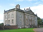
Dumfries House Cumnock NS5414120398 55°27′20″N 4°18′29″W / 55.455633°N 4.308085°W / 55.455633; -4.308085 (Dumfries House ) Country house built 1759 to designs by John , Robert and James Adam [29] 14413 Upload another image See more images
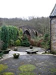
Dumfries House , Avenue Bridge Over the River Lugar in Dumfries House estate, Cumnock NS5379820643 55°27′28″N 4°18′49″W / 55.45773°N 4.313633°W / 55.45773; -4.313633 (Dumfries House, Avenue Bridge ) Three-arch bridge contemporary with the house [30] 14414 Upload another image See more images
Dumfries House Dovecote Dumfries House estate, Cumnock NS5395120350 55°27′19″N 4°18′40″W / 55.455145°N 4.311061°W / 55.455145; -4.311061 (Dumfries House Dovecote ) 17th-century dovecote [31] 14416 Upload another image See more images
Mauchline Castle (Abbot Hunter's Tower) Mauchline NS4977127264 55°30′57″N 4°22′51″W / 55.515952°N 4.38084°W / 55.515952; -4.38084 (Mauchline Castle (Abbot Hunter's Tower) ) Former grange of Melrose Abbey , c. 1450 [32] 14471 Upload another image
Ballochmyle Viaduct Over the River Ayr near Mauchline NS5087925392 55°29′58″N 4°21′44″W / 55.499485°N 4.362302°W / 55.499485; -4.362302 (Ballochmyle Viaduct ) Railway viaduct opened in 1850 [33] 14483 Upload another image See more images
Kennox House West of Stewarton NS3846944946 55°40′16″N 4°34′12″W / 55.671062°N 4.570004°W / 55.671062; -4.570004 (Kennox House ) Mid-18th-century house with substantial early-19th-century additions [34] 18490 Upload another image See more images
High Williamshaw North-east of Stewarton NS4400748326 55°42′12″N 4°29′02″W / 55.703214°N 4.483965°W / 55.703214; -4.483965 (High Williamshaw ) Late-18th-century gentleman's house [35] 18496 Upload another image
Treesbanks House Dovecot Ayr Road, Kilmarnock NS4196234522 55°34′43″N 4°30′31″W / 55.57864°N 4.508536°W / 55.57864; -4.508536 (Treesbanks House Dovecot ) Dovecote of 1771 [36] 18512 Caprington Castle West of Kilmarnock NS4077536251 55°35′38″N 4°31′42″W / 55.593774°N 4.528343°W / 55.593774; -4.528343 (Caprington Castle ) Gothic mansion of c. 1820, incorporating and earlier building [37] 18517 Upload another image See more images
Craigengillan South of Dalmellington NS4735002817 55°17′45″N 4°24′21″W / 55.295726°N 4.405767°W / 55.295726; -4.405767 (Craigengillan ) 18th-century house, enlarged in the Gothic style in the 19th century [38] 18793 Upload another image
Craigengillan Stable Block Craigengillan, south of Dalmellington NS4736502755 55°17′43″N 4°24′20″W / 55.295174°N 4.405497°W / 55.295174; -4.405497 (Craigengillan Stable Block ) Late-18th-century classical stable court [39] 18794 Upload another image
Loch Doon Castle Loch Doon NX4881494758 55°13′26″N 4°22′42″W / 55.223824°N 4.378403°W / 55.223824; -4.378403 (Loch Doon Castle ) Remains of an eleven-sided curtain-wall castle [40] 18795 Upload another image See more images
Barskimming New Bridge Over River Ayr at Barskimming, Mauchline NS4821425194 55°29′49″N 4°24′16″W / 55.496887°N 4.404342°W / 55.496887; -4.404342 (Barskimming New Bridge ) Later 18th-century bridge, with adjacent estate workers' houses and a viewing platform [41] 19483 Upload another image See more images
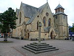
Cumnock Mercat Cross The Square, Cumnock NS5678320132 55°27′14″N 4°15′58″W / 55.454025°N 4.266206°W / 55.454025; -4.266206 (Cumnock Mercat Cross ) Mercat cross dating to 1703 [42] 24093 Upload another image See more images
Bank (or Templand) Railway Viaduct Over Lugar Water in Woodroad Park, Cumnock NS5739520624 55°27′31″N 4°15′24″W / 55.458621°N 4.256789°W / 55.458621; -4.256789 (Bank (or Templand) Railway Viaduct ) 13-arch viaduct completed 1850 [43] 24133 Upload another image See more images
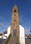
St Sophia's Roman Catholic Church Bentinck Street, Galston NS5028436510 55°35′57″N 4°22′40″W / 55.599116°N 4.377734°W / 55.599116; -4.377734 (St Sophia's Roman Catholic Church ) Byzantine -style church of 1886 by Robert Weir Schultz [44] 32010 Upload another image See more images
Laigh Kirk Bank Street, Kilmarnock NS4276737948 55°36′35″N 4°29′52″W / 55.609654°N 4.497734°W / 55.609654; -4.497734 (Laigh Kirk ) Early-19th-century church with 17th-century tower [45] 35875 Upload another image
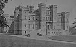
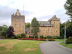
Dean Castle Dean Road, Kilmarnock NS4368439416 55°37′23″N 4°29′02″W / 55.623128°N 4.484025°W / 55.623128; -4.484025 (Dean Castle ) Late-14th- or early-15th-century tower house with later additions, restored in the 20th century [46] 35884 Upload another image See more images
Palace Theatre , former Corn Exchange Green Street, Kilmarnock NS4298237941 55°36′35″N 4°29′40″W / 55.609661°N 4.49432°W / 55.609661; -4.49432 (Palace Theatre, former Corn Exchange ) Italianate corn exchange built 1863 by James Ingram, converted in the 20th century [47] 35903 Upload another image See more images
Holy Trinity Episcopal Church Dundonald Road, Kilmarnock NS4258737720 55°36′27″N 4°30′02″W / 55.60755°N 4.500458°W / 55.60755; -4.500458 (Holy Trinity Episcopal Church ) Mid 19th-century church, extended in 1876 by George Gilbert Scott [48] 35946 Upload another image
Old High Kirk, including kirkyard with Soulis Monument Soulis Street, Kilmarnock NS4296838249 55°36′45″N 4°29′41″W / 55.612421°N 4.494718°W / 55.612421; -4.494718 (Old High Kirk, including kirkyard with Soulis Monument ) Church of 1740, to designs taken from a James Gibbs pattern book [49] 35965 Upload another image