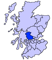
Name Location Date Listed Grid Ref. [note 1] Geo-coordinates Notes LB Number [note 2] Image Lecropt Church Lecropt , Bridge of Allan NS7805097941 56°09′31″N 3°57′54″W / 56.158495°N 3.965053°W / 56.158495; -3.965053 (Lecropt Church ) Gothic Church by William Stirling, 1826 [5] 173 Upload another image See more images
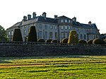
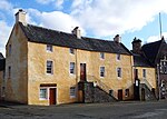
Keir House , Home Farm Bridge of Allan NS7726799296 56°10′14″N 3°58′42″W / 56.170461°N 3.978276°W / 56.170461; -3.978276 (Keir House, Home Farm ) Farm buildings by David Bryce , 1832, remodelled by Sir William Stirling-Maxwell , 1861 [6] 3918 Upload Photo Keir House , South Lodge Bridge of Allan NS7757099093 56°10′07″N 3°58′24″W / 56.168716°N 3.973306°W / 56.168716; -3.973306 (Keir House, South Lodge ) Greek Revival lodge by David Hamilton , 1820 [7] 3921 Upload Photo Keir House Bridge of Allan NS7697098807 56°09′58″N 3°58′58″W / 56.165994°N 3.98283°W / 56.165994; -3.98283 (Keir House ) Georgian mansion, extended by David Hamilton in 1831 and Robert Rowand Anderson in 1901 [8] 3935 Upload another image See more images
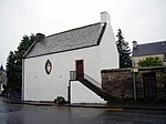
Old Auchentroig Auchentroig, Buchlyvie NS5444693521 56°06′44″N 4°20′32″W / 56.112193°N 4.342346°W / 56.112193; -4.342346 (Old Auchentroig ) Laird's house dated 1702, restored by Simpson & Brown 1999 [9] 3937 Upload Photo Queen Victoria School Dunblane NN7893202634 56°12′03″N 3°57′11″W / 56.20086°N 3.953001°W / 56.20086; -3.953001 (Queen Victoria School ) Scots Renaissance school by John A. Campbell, 1908 [10] 3986 Upload Photo Queen Victoria School Memorial Chapel Dunblane NN7894902541 56°12′00″N 3°57′10″W / 56.200029°N 3.952684°W / 56.200029; -3.952684 (Queen Victoria School Memorial Chapel ) Scots Gothic chapel by John A. Campbell, 1908 [11] 3987 Upload Photo Cromlix House , Sundial and Gatepiers Kinbuck , Dunblane NN7819906028 56°13′52″N 3°57′59″W / 56.231147°N 3.966368°W / 56.231147; -3.966368 (Cromlix House, Sundial and Gatepiers ) Well preserved 17th-century obelisk type sundial, with 16th-century gatepiers [12] 3997 Upload another image See more images
Loch Venachar Dam/Sluice House including Weir and Water Conduit Loch Venachar, Callander NN5979206450 56°13′48″N 4°15′48″W / 56.229863°N 4.263271°W / 56.229863; -4.263271 (Loch Venachar Dam/Sluice House including Weir and Water Conduit ) Mid 19th-century dam and water works, built by Glasgow Corporation [13] 4060 Upload another image See more images
Edinample Castle Lochearnhead NN6017822661 56°22′32″N 4°15′56″W / 56.375506°N 4.265651°W / 56.375506; -4.265651 (Edinample Castle ) Z-plan tower house of 1584, remodelled in the late 18th century and renovated in the late 20th century [14] 4198 Upload another image See more images
Drip Old Bridge Craig Forth, Stirling , over River Forth NS7701695615 56°08′14″N 3°58′50″W / 56.137344°N 3.980614°W / 56.137344; -3.980614 (Drip Old Bridge ) Five-arch stone bridge built circa 1773 [15] 6725 Upload Photo Catter House Drymen NS4711487088 56°03′08″N 4°27′23″W / 56.052158°N 4.456459°W / 56.052158; -4.456459 (Catter House ) Late-18th-century classical house [16] 7628 Upload Photo Gribloch House Kippen NS6404893484 56°06′53″N 4°11′17″W / 56.114692°N 4.188042°W / 56.114692; -4.188042 (Gribloch House ) 1930s country house by Basil Spence with Perry Duncan [17] 8191 Upload Photo Doune Stable Block Doune Park, Doune NN7072203150 56°12′12″N 4°05′08″W / 56.203333°N 4.085488°W / 56.203333; -4.085488 (Doune Stable Block ) Quadrangular stable block with octagonal steeple dated 1809 [18] 8220 Upload Photo Old Newton House Doune NN7314001223 56°11′12″N 4°02′44″W / 56.186682°N 4.045618°W / 56.186682; -4.045618 (Old Newton House ) 16th- or 17th-century L-plan tower house [19] 8227 Upload Photo Deanston Mill, Old Spinning Mill Deanston NN7155801600 56°11′23″N 4°04′17″W / 56.189642°N 4.071271°W / 56.189642; -4.071271 (Deanston Mill, Old Spinning Mill ) Five-storey textile mill built 1830 [20] 8230 Upload another image
Deanston Mill, Old Weaving Shed Deanston NN7151901557 56°11′21″N 4°04′19″W / 56.189246°N 4.071879°W / 56.189246; -4.071879 (Deanston Mill, Old Weaving Shed ) Early-19th-century vaulted building [21] 8231 Upload Photo Lanrick Macgregor Monument Lanrick, Doune NN6839802928 56°12′03″N 4°07′22″W / 56.200702°N 4.122811°W / 56.200702; -4.122811 (Lanrick Macgregor Monument ) Early-19th-century monument in the form of a tree trunk, topped by a classical rotunda [22] 8244 Upload Photo Bridge of Dochart Killin , over Falls of Dochart NN5713632505 56°27′47″N 4°19′13″W / 56.462963°N 4.32024°W / 56.462963; -4.32024 (Bridge of Dochart ) Four-arch bridge built 1760 and repaired 1831 [23] 8275 Upload another image See more images
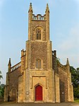
Killin Railway Viaduct Killin , over River Dochart NN5743532756 56°27′55″N 4°18′56″W / 56.465307°N 4.315529°W / 56.465307; -4.315529 (Killin Railway Viaduct ) Built for the Killin Railway in 1886, the second-oldest mass-concrete railway viaduct in Britain [24] 8281 Upload Photo Kincardine Parish Church Kincardine-in-Menteith, Blair Drummond NS7192098851 56°09′54″N 4°03′51″W / 56.165058°N 4.064117°W / 56.165058; -4.064117 (Kincardine Parish Church ) Gothic church by Richard Crichton, 1816 [25] 8431 Upload another image See more images
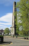
Buchanan Monument Killearn NS5227385975 56°02′38″N 4°22′23″W / 56.043787°N 4.373089°W / 56.043787; -4.373089 (Buchanan Monument ) Obelisk monument to George Buchanan (1506–1582), erected 1788 [26] 10389 Upload another image
Auchenibert Killearn NS5308485780 56°02′32″N 4°21′36″W / 56.042286°N 4.359975°W / 56.042286; -4.359975 (Auchenibert ) Elizabethan-style Arts and Crafts house by Charles Rennie Mackintosh , 1906 [27] 10422 Upload Photo Gargunnock House Gargunnock NS7155594503 56°07′33″N 4°04′04″W / 56.125921°N 4.067892°W / 56.125921; -4.067892 (Gargunnock House ) Late-16th-century house with 17th- and 18th-century additions [28] 10438 Upload another image
Old Leckie House Gargunnock NS6898094690 56°07′37″N 4°06′34″W / 56.126899°N 4.109377°W / 56.126899; -4.109377 (Old Leckie House ) 16th-century laird's house, restored in the 1970s [29] 10445 Upload Photo Blairlogie Castle Blairlogie NS8275196964 56°09′03″N 3°53′20″W / 56.150902°N 3.88898°W / 56.150902; -3.88898 (Blairlogie Castle ) 16th-century tower house [30] 10461 Upload Photo Culcreuch Castle Fintry NS6202587679 56°03′43″N 4°13′03″W / 56.061996°N 4.217552°W / 56.061996; -4.217552 (Culcreuch Castle ) Late medieval tower house and 18th-century mansion [31] 10467 Upload another image See more images
Dun Eaglais Kippen , Station Road NS6538194887 56°07′40″N 4°10′02″W / 56.127666°N 4.16733°W / 56.127666; -4.16733 (Dun Eaglais ) Arts and Crafts mansion of 1903 with later additions [32] 12515 Upload Photo Milnholm Hatchery Milnholm, Stirling NS7841987676 56°03′59″N 3°57′16″W / 56.066417°N 3.954436°W / 56.066417; -3.954436 (Milnholm Hatchery ) 19th-century purpose-built fish hatchery [33] 15275 Upload Photo Bannockburn House Bannockburn NS8088588881 56°04′40″N 3°54′55″W / 56.077858°N 3.915389°W / 56.077858; -3.915389 (Bannockburn House ) 17th- or 18th-century country house [34] 15277 Upload Photo Touch House Touch, Stirling NS7532892755 56°06′40″N 4°00′23″W / 56.111226°N 4.006421°W / 56.111226; -4.006421 (Touch House ) 16th-century tower house and 17th-century house, with Georgian facade by William Adam [35] 15295 Upload Photo Auchenbowie House Auchenbowie, Stirling September 5, 1973 NS7986787405 56°03′52″N 3°55′52″W / 56.06435°N 3.931071°W / 56.06435; -3.931071 (Auchenbowie House ) 17th-century house with 18th- and 19th-century alterations [36] 15303 Upload Photo Howietoun Fishery Howietoun, Stirling NS7851388381 56°04′22″N 3°57′12″W / 56.072772°N 3.953247°W / 56.072772; -3.953247 (Howietoun Fishery ) Later 19th-century fish farm with hatchery and pools [37] 15306 Upload Photo Hayford Mills Cambusbarron , Stirling NS7753092843 56°06′45″N 3°58′16″W / 56.112586°N 3.971075°W / 56.112586; -3.971075 (Hayford Mills ) 19th-century textile mills [38] 19117 Upload Photo Cardross House Arnprior NS6046397659 56°09′04″N 4°14′52″W / 56.151139°N 4.247835°W / 56.151139; -4.247835 (Cardross House ) 16th-century tower house with 18th- and 19th-century additions [39] 19708 Upload another image
Bridge of Ardoch Doune , over Ardoch Burn NN7299601296 56°11′14″N 4°02′53″W / 56.187299°N 4.047971°W / 56.187299; -4.047971 (Bridge of Ardoch ) Single span stone bridge dated 1735 [40] 24667 Upload another image
Bridge of Teith Doune , over River Teith NN7216801244 56°11′12″N 4°03′41″W / 56.18661°N 4.061278°W / 56.18661; -4.061278 (Bridge of Teith ) Two-arch bridge of 1535 with 19th-century widening [41] 24668 Upload another image
Doune Market Cross Doune NN7270401570 56°11′23″N 4°03′10″W / 56.189681°N 4.052804°W / 56.189681; -4.052804 (Doune Market Cross ) Mercat cross of circa 1620 [42] 24671 Upload another image
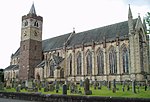
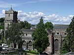
Dunblane Cathedral Dunblane NN7815301381 56°11′22″N 3°57′54″W / 56.18941°N 3.964973°W / 56.18941; -3.964973 (Dunblane Cathedral ) 13th-century church with 12th-century tower, 19th-century restoration by Robert Rowand Anderson [43] 26361 Upload another image See more images
Ault Wharrie Dunblane , Leewood Road NN7920500909 56°11′08″N 3°56′52″W / 56.18544°N 3.947818°W / 56.18544; -3.947818 (Ault Wharrie ) Glasgow Style mansion, 1900 by George Walton [44] 26365 Upload Photo Leighton Library Dunblane NN7818501292 56°11′19″N 3°57′52″W / 56.188619°N 3.964417°W / 56.188619; -3.964417 (Leighton Library ) 17th-century purpose-built library, the oldest in Scotland [45] 26371 Upload another image See more images
Cathedral Museum Dunblane NN7820901341 56°11′21″N 3°57′51″W / 56.189065°N 3.964053°W / 56.189065; -3.964053 (Cathedral Museum ) 17th-century tenement and former townhouse, altered in the 18th century [46] 26372 Upload another image See more images
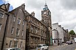
Church Of The Holy Rood Stirling , St John Street NS7920693710 56°07′15″N 3°56′40″W / 56.120798°N 3.944533°W / 56.120798; -3.944533 (Church Of The Holy Rood ) 15th-century church with many later additions and alterations [47] 41083 Upload another image See more images
Church Of The Holy Rood Churchyard Stirling , St John Street NS7917593778 56°07′17″N 3°56′42″W / 56.121401°N 3.945062°W / 56.121401; -3.945062 (Church Of The Holy Rood Churchyard ) Churchyard monuments from 1579 onwards [48] 41084 Upload another image See more images
Holy Trinity Episcopal Church Stirling , Dumbarton Road NS7930093428 56°07′06″N 3°56′34″W / 56.11829°N 3.942894°W / 56.11829; -3.942894 (Holy Trinity Episcopal Church ) Gothic church by Robert Rowand Anderson , 1878 [49] 41089 Upload another image
St Ninians Old Parish Kirk Stirling , St Ninians NS7956491677 56°06′09″N 3°56′16″W / 56.102634°N 3.93786°W / 56.102634; -3.93786 (St Ninians Old Parish Kirk ) Remains of 15th-century church and 18th-century steeple [50] 41095 Upload Photo St Ninians Old Parish Kirkyard Stirling , St Ninians NS7959091678 56°06′10″N 3°56′15″W / 56.102649°N 3.937443°W / 56.102649; -3.937443 (St Ninians Old Parish Kirkyard ) Churchyard monuments, mainly 17th-century [51] 41096 Upload another image
Athenaeum Stirling , King Street NS7956793444 56°07′07″N 3°56′19″W / 56.118501°N 3.93861°W / 56.118501; -3.93861 (Athenaeum ) Classical gentlemen's club by William Stirling, 1817 [52] 41100 Upload another image
Cowane's Hospital (now Guildhall) Stirling , St John Street NS7917393674 56°07′14″N 3°56′42″W / 56.120467°N 3.945047°W / 56.120467; -3.945047 (Cowane's Hospital (now Guildhall) ) 17th-century hospital by John Mylne [53] 41101 Upload another image See more images
Stirling Old Town Jail (former Military Prison) Stirling , St John Street NS7923393615 56°07′12″N 3°56′39″W / 56.119952°N 3.944056°W / 56.119952; -3.944056 (Stirling Old Town Jail (former Military Prison) ) Jail by Thomas Brown, 1847, converted to a museum in the 1990s [54] 41104 Upload another image
Stirling Tolbooth Stirling , Broad Street NS7931093694 56°07′14″N 3°56′34″W / 56.120681°N 3.942854°W / 56.120681; -3.942854 (Stirling Tolbooth ) Burgh tolbooth built 1705 to designs by Sir William Bruce , converted to a theatre in 2001 by Richard Murphy [55] 41110 Upload another image See more images
Stirling Town Wall, south boundary of Erskine Marykirk and St John Street Housing Development to Academy Street Stirling , Back Walk NS7945193409 56°07′05″N 3°56′26″W / 56.118158°N 3.940459°W / 56.118158; -3.940459 (Stirling Town Wall, south boundary of Erskine Marykirk and St John Street Housing Development to Academy Street ) Remnant of 16th-century town wall [56] 41111 Upload Photo Stirling Town Wall and Bastion, boundary of Municipal Buildings, 27-33 Spittal Street and Old High School Stirling , Back Walk NS7943893420 56°07′06″N 3°56′26″W / 56.118253°N 3.940672°W / 56.118253; -3.940672 (Stirling Town Wall and Bastion, boundary of Municipal Buildings, 27-33 Spittal Street and Old High School ) Remnant of 16th-century town wall with beehive-shaped bastion [57] 41112 Upload Photo Stirling Town Wall, Public Library to 16 Dumbarton Road Stirling NS7945193409 56°07′05″N 3°56′26″W / 56.118158°N 3.940459°W / 56.118158; -3.940459 (Stirling Town Wall, Public Library to 16 Dumbarton Road ) Remnant of 16th-century town wall [58] 41113 Upload Photo Wallace Monument Stirling , Abbey Craig NS8092395667 56°08′20″N 3°55′04″W / 56.138803°N 3.917808°W / 56.138803; -3.917808 (Wallace Monument ) Monumental tower by John Thomas Rochead , completed 1869 [59] 41118 Upload another image See more images
The Old Town Cemeteries Stirling , St John Street NS7917593778 56°07′17″N 3°56′42″W / 56.121401°N 3.945062°W / 56.121401; -3.945062 (The Old Town Cemeteries ) 19th- and 20th-century extensions of Holy Rood Churchyard [60] 41126 Upload another image See more images
Stirling Old Bridge Stirling NS7971294568 56°07′43″N 3°56′12″W / 56.128631°N 3.936786°W / 56.128631; -3.936786 (Stirling Old Bridge ) Late-15th- or early-16th-century four-arch bridge [61] 41129 Upload another image See more images
Stirling Railway Station Stirling NS7975893580 56°07′11″N 3°56′08″W / 56.119771°N 3.935601°W / 56.119771; -3.935601 (Stirling Railway Station ) Station buildings by James Miller , 1915 [62] 41131 Upload another image See more images
Stirling Highland Hotel, Old High School Stirling , Academy Road NS7934493508 56°07′08″N 3°56′32″W / 56.11902°N 3.942223°W / 56.11902; -3.942223 (Stirling Highland Hotel, Old High School ) School by J, W H & J M Hay, 1856, extended in 1905 and converted to a hotel in 1990 [63] 41133 Upload another image
Stirling Castle, Outer Defences (1708–14) Stirling NS7906894007 56°07′24″N 3°56′49″W / 56.12343°N 3.946886°W / 56.12343; -3.946886 (Stirling Castle, Outer Defences (1708–14) ) Early-18th-century artillery defences [64] 41136 Upload another image See more images
Stirling Castle, Forework (1500–1510) Stirling NS7904494025 56°07′25″N 3°56′50″W / 56.123586°N 3.94728°W / 56.123586; -3.94728 (Stirling Castle, Forework (1500–1510) ) Early-16th-century gatehouse, now much reduced [65] 41137 Upload another image See more images
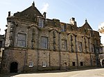
Stirling Castle Palace (1539–42) Stirling NS7899694035 56°07′25″N 3°56′53″W / 56.123663°N 3.948056°W / 56.123663; -3.948056 (Stirling Castle Palace (1539–42) ) Mid 16th-century Renaissance palace built for King James V [66] 41138 Upload another image See more images
Stirling Castle, Great Hall (1503) Stirling NS7901794077 56°07′27″N 3°56′52″W / 56.124046°N 3.947737°W / 56.124046; -3.947737 (Stirling Castle, Great Hall (1503) ) Early-16th-century hall, later used as a barracks and recently restored [67] 41139 Upload another image See more images
Stirling Castle Chapel Royal (1594) Stirling NS7898494096 56°07′27″N 3°56′54″W / 56.124208°N 3.948277°W / 56.124208; -3.948277 (Stirling Castle Chapel Royal (1594) ) Late-16th-century chapel [68] 41140 Upload another image See more images
Stirling Castle, The Mint (14th-century) Stirling NS7903094095 56°07′27″N 3°56′51″W / 56.124211°N 3.947537°W / 56.124211; -3.947537 (Stirling Castle, The Mint (14th-century) ) 14th-century gatehouse with later extensions [69] 41141 Upload another image See more images
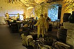
Stirling Castle, Kitchen Range and Grand Battery Stirling NS7904994068 56°07′26″N 3°56′50″W / 56.123973°N 3.947219°W / 56.123973; -3.947219 (Stirling Castle, Kitchen Range and Grand Battery ) Early-18th-century vaulted kitchens, restored 1920s [70] 41142 Upload another image See more images
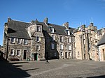
Stirling Castle, King's Old Building Stirling NS7896194073 56°07′26″N 3°56′55″W / 56.123996°N 3.948636°W / 56.123996; -3.948636 (Stirling Castle, King's Old Building ) 16th-century range, altered by Robert William Billings , 1855 [71] 41143 Upload another image See more images
Stirling Castle , Sundial Stirling NS7895494116 56°07′28″N 3°56′56″W / 56.12438°N 3.948768°W / 56.12438; -3.948768 (Stirling Castle, Sundial ) 17th-century sundial [72] 41144 Upload Photo Stirling Castle, Regimental Headquarters Stirling NS7906494043 56°07′26″N 3°56′49″W / 56.123753°N 3.946967°W / 56.123753; -3.946967 (Stirling Castle, Regimental Headquarters ) 18th-century military building [73] 41145 Upload Photo Erskine Of Gogar's House (Darnley's House) Stirling , Bow Street NS7938593684 56°07′14″N 3°56′30″W / 56.12061°N 3.941644°W / 56.12061; -3.941644 (Erskine Of Gogar's House (Darnley's House) ) Late-16th- or early-17th-century tenement house [74] 41239 Upload another image
Moir of Leckie's House Stirling , Bow Street NS7941493678 56°07′14″N 3°56′28″W / 56.120564°N 3.941175°W / 56.120564; -3.941175 (Moir of Leckie's House ) Mid 17th-century town house [75] 41240 Upload Photo East Section of James Norrie's Lodging Stirling , Broad Street NS7932393720 56°07′15″N 3°56′34″W / 56.120918°N 3.942657°W / 56.120918; -3.942657 (East Section of James Norrie's Lodging ) 17th-century town house, rebuilt in the 1950s [76] 41246 Upload another image
Argyll Lodging Stirling , Castle Wynd NS7926193808 56°07′18″N 3°56′37″W / 56.121692°N 3.943693°W / 56.121692; -3.943693 (Argyll Lodging ) 17th-century courtyard-plan town house [77] 41255 Upload another image See more images
Mar's Wark Stirling , Mar Place NS7923293744 56°07′16″N 3°56′39″W / 56.12111°N 3.94413°W / 56.12111; -3.94413 (Mar's Wark ) Remains of 16th-century courtyard town house [78] 41348 Upload another image See more images
Bruce of Auchenbowie's House Stirling , St John Street NS7925493676 56°07′14″N 3°56′37″W / 56.120505°N 3.943746°W / 56.120505; -3.943746 (Bruce of Auchenbowie's House ) 16th-century town house with later alterations [79] 41464 Upload Photo John Cowane's House Stirling , St Mary's Wynd NS7932693851 56°07′20″N 3°56′34″W / 56.122095°N 3.942668°W / 56.122095; -3.942668 (John Cowane's House ) Remains of 17th-century town house [80] 41466 Upload Photo Glengarry Lodge or Darrow Lodging Stirling , Spittal Street NS7938093599 56°07′11″N 3°56′30″W / 56.119846°N 3.941686°W / 56.119846; -3.941686 (Glengarry Lodge or Darrow Lodging ) 17th-century town house, rebuilt in the 1950s [81] 41484 Upload Photo Deanston Mills, Weir Deanston NN7030902667 56°11′56″N 4°05′31″W / 56.198884°N 4.091904°W / 56.198884; -4.091904 (Deanston Mills, Weir ) The largest weir of its type in Scotland, built circa 1827 to power textile mill [82] 47650 Upload Photo Bannockburn Rotunda, Memorial Cairn, Flagpole and Statue of King Robert I Bannockburn , Borestone Brae NS7948890691 56°05′38″N 3°56′19″W / 56.093761°N 3.938636°W / 56.093761; -3.938636 (Bannockburn Rotunda, Memorial Cairn, Flagpole and Statue of King Robert I ) Battle of Bannockburn (1314) battlefield memorial with statue by Charles d'Orville Pilkington Jackson [83] 49860 Upload another image See more images
Cayzer Family Private Cemetery, Sundial Gartmore NS5208897164 56°08′39″N 4°22′56″W / 56.144171°N 4.382252°W / 56.144171; -4.382252 (Cayzer Family Private Cemetery, Sundial ) 17th-century sandstone obelisk sundial, one of only 25 to survive in Scotland [84] 50406 Upload Photo