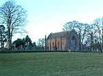
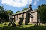
Name Location Date Listed Grid Ref. [note 1] Geo-coordinates Notes LB Number [note 2] Image Airlie Parish Kirk Airlie NO3132351526 56°39′02″N 3°07′18″W / 56.650477°N 3.121651°W / 56.650477; -3.121651 (Airlie Parish Kirk ) 18th-century church [5] 4621 Upload another image See more images
Barry Mill Barry 11/11/2009 NO5341134966 56°30′16″N 2°45′31″W / 56.504443°N 2.758482°W / 56.504443; -2.758482 (Barry Mill ) A water-powered, working meal mill [6] 4649 Upload another image See more images
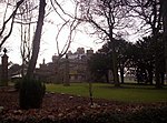
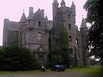
Careston Castle Careston NO5307459888 56°43′42″N 2°46′07″W / 56.728283°N 2.768492°W / 56.728283; -2.768492 (Careston Castle ) Late-16th-century tower house with later additions [7] 4656 Upload another image See more images
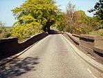
Bridge of Dun Near House of Dun , over the River South Esk , Montrose NO6627258424 56°42′59″N 2°33′09″W / 56.716275°N 2.552627°W / 56.716275; -2.552627 (Bridge of Dun ) Three-arch stone bridge, completed 1787 by Alexander Stevens [8] 4677 Upload another image See more images
House of Dun Montrose NO6704359881 56°43′46″N 2°32′25″W / 56.729418°N 2.54022°W / 56.729418; -2.54022 (House of Dun ) Country house by William Adam , circa 1730 [9] 4691 Upload another image See more images
House of Dun court of offices Montrose NO6698459872 56°43′46″N 2°32′28″W / 56.729333°N 2.541183°W / 56.729333; -2.541183 (House of Dun court of offices ) By William Adam , circa 1730 [10] 4692 Upload another image See more images
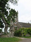
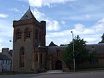
St. Vigeans Parish Kirk St Vigeans , Arbroath NO6384242912 56°34′36″N 2°35′25″W / 56.576744°N 2.590142°W / 56.576744; -2.590142 (St. Vigeans Parish Kirk ) 12th- and 15th-century church, restored in 1871 by Robert Rowand Anderson [11] 4770 Upload another image See more images
Melgund Castle Aberlemno NO5460956330 56°41′47″N 2°44′34″W / 56.696474°N 2.742779°W / 56.696474; -2.742779 (Melgund Castle ) Later 16th-century tower house [12] 4931 Upload another image See more images
Usan House Kirkton of Craig, Montrose NO7221055227 56°41′17″N 2°27′19″W / 56.687947°N 2.455275°W / 56.687947; -2.455275 (Usan House ) Classical mansion of 1820 [13] 4964 Upload another image See more images
Dunninald Castle Kirkton of Craig, Montrose 1971 NO7034354271 56°40′45″N 2°29′08″W / 56.679244°N 2.485641°W / 56.679244; -2.485641 (Dunninald Castle ) Tudor-Gothic castellated mansion by James Gillespie Graham , 1824 [14] 4972 Upload another image See more images
Kirk Tower House Kirkton Of Craig, Montrose NO7036955785 56°41′34″N 2°29′07″W / 56.692847°N 2.485392°W / 56.692847; -2.485392 (Kirk Tower House ) Former church built 1799, the earliest Gothic Revival church to be built in Scotland [15] 4979 Upload another image
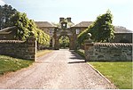
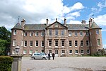
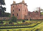
Craig House Kirkton Of Craig, Montrose NO7028556243 56°41′49″N 2°29′13″W / 56.696956°N 2.486817°W / 56.696956; -2.486817 (Craig House ) 17th-century L-plan house [16] 4984 Upload Photo Craig House - Entrance Gateway Kirkton Of Craig, Montrose NO7033356217 56°41′48″N 2°29′10″W / 56.696725°N 2.48603°W / 56.696725; -2.48603 (Craig House - Entrance Gateway ) 16th-century defensive gateway [17] 4985 Upload Photo Kintrockat House Brechin NO5684159131 56°43′19″N 2°42′25″W / 56.721847°N 2.706808°W / 56.721847; -2.706808 (Kintrockat House ) Early-19th-century house [18] 5011 Upload Photo Ardovie House Ardovie , Brechin NO5931656483 56°41′54″N 2°39′57″W / 56.698283°N 2.665951°W / 56.698283; -2.665951 (Ardovie House ) 18th-century country house [19] 5016 Upload Photo Brechin Castle Brechin NO5978259892 56°43′44″N 2°39′32″W / 56.728946°N 2.658877°W / 56.728946; -2.658877 (Brechin Castle ) Early-18th-century mansion with 19th-century remodelling [20] 5030 Upload another image See more images
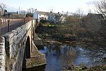
Stannochy Bridge Over the River South Esk near Brechin NO5837259111 56°43′19″N 2°40′54″W / 56.721807°N 2.681791°W / 56.721807; -2.681791 (Stannochy Bridge ) Single-arch stone bridge dated 1825, possibly by Robert Stevenson [21] 5042 Upload another image See more images
Auchterhouse Old Mansion House Auchterhouse NO3311337289 56°31′22″N 3°05′20″W / 56.522857°N 3.088781°W / 56.522857; -3.088781 (Auchterhouse Old Mansion House ) 17th-century mansion with 18th- and 19th-century additions, now a hotel [22] 5689 Upload another image See more images
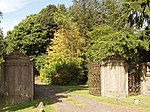
Auchterhouse Old Mansion House, Dovecot Auchterhouse NO3321337345 56°31′24″N 3°05′14″W / 56.523374°N 3.087171°W / 56.523374; -3.087171 (Auchterhouse Old Mansion House, Dovecot ) 17th-century dovecote [23] 5690 Upload Photo Balruddery, East Gates Balruddery House, Liff NO3190531830 56°28′25″N 3°06′25″W / 56.473649°N 3.106982°W / 56.473649; -3.106982 (Balruddery, East Gates ) Gateway designed by David Neave in 1820 for Balruddery House, now demolished [24] 10854 Upload another image
Gallery Marykirk NO6731965612 56°46′51″N 2°32′11″W / 56.780921°N 2.536443°W / 56.780921; -2.536443 (Gallery ) 17th- and 18th-century country house [25] 11165 Upload Photo Upper North Water Bridge Over River North Esk near Marykirk Delisted NO6527166139 56°47′08″N 2°34′12″W / 56.785506°N 2.570029°W / 56.785506; -2.570029 (Upper North Water Bridge ) 16th-century three-arch stone bridge, rebuilt in the 19th century [26] [note 3] 11170 Upload another image See more images
Marykirk Bridge Over River North Esk at Marykirk NO6859765008 56°46′32″N 2°30′56″W / 56.775583°N 2.515455°W / 56.775583; -2.515455 (Marykirk Bridge ) Four-arch stone bridge by Robert Stevenson , 1814 [27] [note 3] 11177 Upload Photo Marykirk Bridge, Tollhouse Marykirk NO6854964977 56°46′31″N 2°30′58″W / 56.775301°N 2.516237°W / 56.775301; -2.516237 (Marykirk Bridge, Tollhouse ) Single-storey toll house by Robert Stevenson , 1814 [28] 11178 Upload Photo Edzell Castle Edzell Delisted NO5846169108 56°48′42″N 2°40′55″W / 56.811617°N 2.681964°W / 56.811617; -2.681964 (Edzell Castle ) Remains of 16th-century castle with 17th-century additions and formal garden [29] 11257 Upload another image See more images
Red Castle - Enceinte Lunan NO6878351079 56°39′02″N 2°30′39″W / 56.650467°N 2.510713°W / 56.650467; -2.510713 (Red Castle - Enceinte ) 13th-century defensive wall [30] 11273 Upload another image See more images
Red Castle - Keep Lunan NO6878351079 56°39′02″N 2°30′39″W / 56.650467°N 2.510713°W / 56.650467; -2.510713 (Red Castle - Keep ) Ruins of 15th-century tower house [31] 11274 Upload another image See more images
Ethie Castle Inverkeilor NO6873646844 56°36′45″N 2°30′39″W / 56.61242°N 2.510964°W / 56.61242; -2.510964 (Ethie Castle ) 15th-century tower house with later additions, altered in 1892 by Robert Rowand Anderson [32] 11278 Upload another image See more images
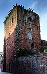
Invermark Castle Glen Mark NO4422280394 56°54′41″N 2°55′03″W / 56.911498°N 2.917627°W / 56.911498; -2.917627 (Invermark Castle ) Early-16th-century tower house with 17th-century additions [33] 11349 Upload another image See more images
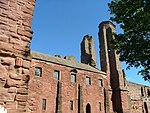
Restenneth Priory Forfar Not listed NO4822251600 56°39′12″N 2°50′46″W / 56.65332°N 2.846103°W / 56.65332; -2.846103 (Restenneth Priory ) Ruins of 13th-century Romanesque church and monastery [34] 11386 Upload another image See more images
Baldovie Farmhouse Kirkton of Kingoldrum NO3243954073 56°40′25″N 3°06′15″W / 56.673517°N 3.104124°W / 56.673517; -3.104124 (Baldovie Farmhouse ) Late-17th-century Renaissance mansion [35] 11417 Upload Photo Farnell Parish Kirk Farnell NO6273855425 56°41′21″N 2°36′36″W / 56.689065°N 2.609922°W / 56.689065; -2.609922 (Farnell Parish Kirk ) Gothic Revival church of 1806 [36] 11497 Upload another image See more images
Farnell Castle Farnell NO6242955488 56°41′23″N 2°36′54″W / 56.689606°N 2.614976°W / 56.689606; -2.614976 (Farnell Castle ) Medieval residence of the Bishops of Brechin, altered in the 16th century [37] 11501 Upload Photo Strathmore Aisle Glamis NO3864446855 56°36′34″N 3°00′04″W / 56.609539°N 3.001165°W / 56.609539; -3.001165 (Strathmore Aisle ) 15th-century aisle of demolished church, later altered, with burial monuments of Lords of Glamis [38] 11556 Upload Photo Inverquharity Castle Kirriemuir NO4112057953 56°42′34″N 2°57′48″W / 56.709544°N 2.963375°W / 56.709544; -2.963375 (Inverquharity Castle ) 15th-century tower house [39] 11665 Upload another image See more images
Mains of Rochelhill Dovecot Charleston NO3750245142 56°35′38″N 3°01′10″W / 56.594001°N 3.019351°W / 56.594001; -3.019351 (Mains of Rochelhill Dovecot ) Lectern dovecote dated 1713 [40] 11670 Upload another image See more images
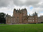
Glamis Castle Glamis NO3858648054 56°37′13″N 3°00′09″W / 56.620301°N 3.002395°W / 56.620301; -3.002395 (Glamis Castle ) 15th-century tower house with 17th-, 18th- and 19th-century ranges, seat of the Earl of Strathmore and Kinghorne [41] 11701 Upload another image See more images
Glamis Castle sundial Glamis NO3863647990 56°37′11″N 3°00′06″W / 56.619733°N 3.001565°W / 56.619733; -3.001565 (Glamis Castle sundial ) Later 17th-century faceted sundial [42] 11705 Upload another image See more images
Glamis Castle dovecot Glamis NO3840747286 56°36′48″N 3°00′18″W / 56.613379°N 3.005128°W / 56.613379; -3.005128 (Glamis Castle dovecot ) Earlier 17th-century lectern dovecot [43] 11710 Upload another image See more images
Pitmuies Home Farm Guthrie NO5671149836 56°38′18″N 2°42′27″W / 56.638338°N 2.707365°W / 56.638338; -2.707365 (Pitmuies Home Farm ) Late-18th-century farmstead with horse mill [44] 11875 Upload Photo Gardyne Castle Friockheim NO5736948790 56°37′44″N 2°41′47″W / 56.629002°N 2.696465°W / 56.629002; -2.696465 (Gardyne Castle ) 16th-century L-plan tower house with later additions [45] 11914 Upload another image See more images
Braikie Castle Friockheim NO6284650893 56°38′54″N 2°36′27″W / 56.648362°N 2.607504°W / 56.648362; -2.607504 (Braikie Castle ) Remains of 16th-century L-plan tower house [46] 12325 Upload another image See more images
Mains of Edzell Doocot Edzell NO5886869079 56°48′41″N 2°40′31″W / 56.811393°N 2.675294°W / 56.811393; -2.675294 (Mains of Edzell Doocot ) Turreted dovecote of circa 1600 [47] 12385 Upload another image
Pitmuies House Guthrie NO5672049762 56°38′16″N 2°42′26″W / 56.637674°N 2.707206°W / 56.637674; -2.707206 (Pitmuies House ) Later 18th-century mansion [48] 13076 Upload another image See more images
Lundie Parish Church Lundie NO2906236610 56°30′58″N 3°09′16″W / 56.516164°N 3.154426°W / 56.516164; -3.154426 (Lundie Parish Church ) Medieval Romanesque church, rebuilt 19th century, and Duncan family mausoleum by Robert Mylne [49] 13090 Upload another image See more images
Fowlis Easter Parish Church Fowlis, Liff NO3221033455 56°29′18″N 3°06′09″W / 56.48829°N 3.102455°W / 56.48829; -3.102455 (Fowlis Easter Parish Church ) 15th-century church [50] 13144 Upload another image See more images
Balintore Castle 10 kilometres (6.2 mi) north-west of Kirriemuir NO2902859015 56°43′03″N 3°09′40″W / 56.717399°N 3.16114°W / 56.717399; -3.16114 (Balintore Castle ) Derelict Baronial mansion, 1860 by William Burn [51] 13757 Upload another image See more images
Tealing Parish Church Tealing NO4035037943 56°31′47″N 2°58′17″W / 56.529707°N 2.971322°W / 56.529707; -2.971322 (Tealing Parish Church ) Early-19th-century former church, incorporating several sculpted stones within its walls [52] 17450 Upload another image See more images
South Balluderon Farm Tealing NO3755438078 56°31′50″N 3°01′00″W / 56.530556°N 3.016801°W / 56.530556; -3.016801 (South Balluderon Farm ) Unaltered farm buildings and mill dating to circa 1800 [53] 17458 Upload Photo Pitscandly House Forfar NO4842752537 56°39′42″N 2°50′35″W / 56.661759°N 2.842948°W / 56.661759; -2.842948 (Pitscandly House ) Late-17th-century mansion [54] 17657 Upload Photo Balnamoon House sundial Balnamoon House, near Brechin NO5514663689 56°45′45″N 2°44′07″W / 56.762631°N 2.735301°W / 56.762631; -2.735301 (Balnamoon House sundial ) Lectern sundial circa 1700 [55] 17700 Upload Photo House of Kinnaber Montrose NO7256061751 56°44′48″N 2°27′01″W / 56.746576°N 2.450262°W / 56.746576; -2.450262 (House of Kinnaber ) L-plan mansion dated 1680 [56] 17762 Upload another image See more images
Stracathro House Stracathro NO6257265561 56°46′48″N 2°36′51″W / 56.780104°N 2.614116°W / 56.780104; -2.614116 (Stracathro House ) Graeco-Roman mansion by Archibald Simpson , 1827 [57] 17803 Upload another image See more images
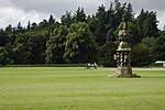
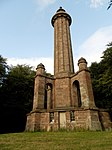
Stracathro House stables Stracathro NO6237065575 56°46′49″N 2°37′03″W / 56.780214°N 2.617423°W / 56.780214; -2.617423 (Stracathro House stables ) Stable block by Archibald Simpson , 1827 [58] 17804 Upload Photo Downie Park House Kirriemuir NO4086458572 56°42′54″N 2°58′04″W / 56.715072°N 2.967698°W / 56.715072; -2.967698 (Downie Park House ) Country house circa 1805 [59] 18034 Upload Photo Panmure Estate - The West Gate Craigton NO5309038445 56°32′08″N 2°45′52″W / 56.535663°N 2.764325°W / 56.535663; -2.764325 (Panmure Estate - The West Gate ) Renaissance-style gateway by Sir William Bruce , circa 1672 [60] 18418 Upload Photo Panmure Estate , Commemorative Column Craigton NO5375538956 56°32′25″N 2°45′13″W / 56.540319°N 2.753605°W / 56.540319; -2.753605 (Panmure Estate, Commemorative Column ) 50-foot (15 m) Renaissance column, commemorating the 1694 marriage of James Maule, 4th Earl of Panmure [61] 18419 Upload another image
Tealing House Dovecot Tealing Delisted NO4128338134 56°31′54″N 2°57′22″W / 56.53154°N 2.9562°W / 56.53154; -2.9562 (Tealing House Dovecot ) 16th-century gabled dovecote [62] 18988 Upload another image See more images
Gagie House Murroes NO4492837583 56°31′37″N 2°53′49″W / 56.527033°N 2.896833°W / 56.527033; -2.896833 (Gagie House ) Early-17th-century fortified house with later additions [63] 19001 Upload Photo Gagie House, summerhouse Murroes NO4494037564 56°31′37″N 2°53′48″W / 56.526863°N 2.896634°W / 56.526863; -2.896634 (Gagie House, summerhouse ) 18th-century Renaissance-style summer house [64] 19004 Upload Photo Murroes House Murroes NO4611735034 56°30′15″N 2°52′37″W / 56.504273°N 2.876978°W / 56.504273; -2.876978 (Murroes House ) 16th-century tower house with 17th-century range, restored 1942 [65] 19011 Upload Photo Arbroath Abbey - Abbey Church And Precincts Arbroath NO6431141334 56°33′45″N 2°34′56″W / 56.562604°N 2.582291°W / 56.562604; -2.582291 (Arbroath Abbey - Abbey Church And Precincts ) Ruins of church founded in 1176 by William the Lion [66] 21130 Upload another image
Arbroath Abbey - Conventual Building Arbroath NO6427741297 56°33′44″N 2°34′58″W / 56.562269°N 2.582839°W / 56.562269; -2.582839 (Arbroath Abbey - Conventual Building ) Ruins of 13th-century west range [67] 21131 Upload another image
Arbroath Abbey - Pend Arbroath NO6423641299 56°33′44″N 2°35′01″W / 56.562284°N 2.583507°W / 56.562284; -2.583507 (Arbroath Abbey - Pend ) 15th-century fortified gatehouse [68] 21132 Upload another image
Arbroath Abbey - Regality Tower Arbroath NO6421041286 56°33′44″N 2°35′02″W / 56.562165°N 2.583928°W / 56.562165; -2.583928 (Arbroath Abbey - Regality Tower ) 13th-century keep [69] 21133 Upload another image
Arbroath Abbey - Abbot's House Arbroath NO6427641275 56°33′43″N 2°34′58″W / 56.562072°N 2.582852°W / 56.562072; -2.582852 (Arbroath Abbey - Abbot's House ) Partly 13th-century, the best surviving example of its type in Scotland [70] 21134 Upload another image
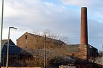
Baltic Works Arbroath , Dens Road NO6394741474 56°33′50″N 2°35′18″W / 56.563834°N 2.588233°W / 56.563834; -2.588233 (Baltic Works ) 1852 linen factory, later a bonded warehouse [71] 21141 Upload another image See more images
Bell Rock Lighthouse Signal Tower and Entrance Lodges Arbroath , Lady Loan NO6405140447 56°33′17″N 2°35′11″W / 56.554616°N 2.586398°W / 56.554616; -2.586398 (Bell Rock Lighthouse Signal Tower and Entrance Lodges ) Classical lodges and signal tower, built 1813 to communicate with the Bell Rock Lighthouse [72] 21230 Upload another image See more images
The Elms Arbroath , Cairnie Road NO6320541750 56°33′59″N 2°36′01″W / 56.566256°N 2.600345°W / 56.566256; -2.600345 (The Elms ) French Gothic mansion by William Leiper, 1869 [73] 21250 Upload Photo Mortuary Chapel - Western Cemetery Arbroath NO6248041770 56°33′59″N 2°36′44″W / 56.566378°N 2.612144°W / 56.566378; -2.612144 (Mortuary Chapel - Western Cemetery ) Baronial chapel, built 1875 by Patrick Allan-Fraser [74] 21252 Upload another image See more images
Hospitalfield Arbroath NO6258340431 56°33′16″N 2°36′37″W / 56.554357°N 2.610275°W / 56.554357; -2.610275 (Hospitalfield ) Mid 19th-century Baronial mansion by Patrick Allan-Fraser [75] 21253 Upload another image See more images
Brechin Cathedral Brechin NO5962560091 56°43′51″N 2°39′41″W / 56.73072°N 2.661474°W / 56.73072; -2.661474 (Brechin Cathedral ) 12th-century onwards, restored circa 1900 by John Honeyman [76] 22439 Upload another image See more images
Round Tower at south west angle of Cathedral Church Lane Brechin NO5962560091 56°43′51″N 2°39′41″W / 56.73072°N 2.661474°W / 56.73072; -2.661474 (Round Tower at south west angle of Cathedral Church Lane ) 11th-century round tower , 101 feet (31 m) high [77] 22440 Upload another image See more images
25, 27 High Street Brechin NO5972960189 56°43′54″N 2°39′35″W / 56.73161°N 2.65979°W / 56.73161; -2.65979 (25, 27 High Street ) 18th-century town houses with shops below [78] 22476 Upload Photo 68-74 High Street Brechin NO5977160095 56°43′51″N 2°39′33″W / 56.730769°N 2.659089°W / 56.730769; -2.659089 (68-74 High Street ) 17th-century or earlier town houses with shops below [79] 22505 Upload Photo Maison Dieu Chapel Brechin NO5966660340 56°43′59″N 2°39′39″W / 56.732961°N 2.660844°W / 56.732961; -2.660844 (Maison Dieu Chapel ) Remains of 13th-century chapel [80] 22508 Upload another image See more images
Baptist Church and Halls Brechin , Panmure Street NO5986660416 56°44′01″N 2°39′27″W / 56.733661°N 2.657587°W / 56.733661; -2.657587 (Baptist Church and Halls ) 19th-century church and hall, formerly West and St Columba's Parish Church [81] 22522 Upload another image See more images
Brechin Bridge Brechin , over River South Esk NO6044159263 56°43′24″N 2°38′53″W / 56.723353°N 2.648011°W / 56.723353; -2.648011 (Brechin Bridge ) Partly 13th-century, rebuilt in the 18th century [82] 22549 Upload another image See more images
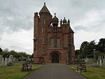
Southesk Church (Former Gardner Memorial Church) Brechin NO6006160166 56°43′53″N 2°39′16″W / 56.731432°N 2.654361°W / 56.731432; -2.654361 (Southesk Church (Former Gardner Memorial Church) ) Mixed Romanesque and late Gothic, 1900 by John James Burnet [83] 22568 Upload another image See more images
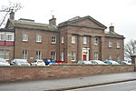
Municipal Buildings Forfar , Castle Street NO4560850663 56°38′41″N 2°53′19″W / 56.644606°N 2.888533°W / 56.644606; -2.888533 (Municipal Buildings ) Built 1824 as Sheriff Court, by David Neave [84] 31542 Upload another image See more images
Lowson Memorial Parish Church Forfar NO4649250881 56°38′48″N 2°52′27″W / 56.646666°N 2.874166°W / 56.646666; -2.874166 (Lowson Memorial Parish Church ) Scots Gothic church, 1914 by Alexander Marshall Mackenzie [85] 31604 Upload another image See more images
St. Mary's Episcopal Church Kirriemuir NO3832654375 56°40′37″N 3°00′29″W / 56.677044°N 3.008145°W / 56.677044; -3.008145 (St. Mary's Episcopal Church ) Gothic revival church, 1905 by Ninian Comper [86] 36899 Upload Photo 174 High Street (Holly House) Montrose NO7140457765 56°42′39″N 2°28′07″W / 56.710698°N 2.468716°W / 56.710698; -2.468716 (174 High Street (Holly House) ) 17th- and 18th-century town house [87] 38041 Upload Photo 190 High Street, The Retreat Montrose NO7139557733 56°42′37″N 2°28′08″W / 56.71041°N 2.468859°W / 56.71041; -2.468859 (190 High Street, The Retreat ) Early-18th-century town house [88] 38046 Upload Photo 214 and 216 High Street, Public Library Montrose NO7137057674 56°42′36″N 2°28′09″W / 56.709879°N 2.469261°W / 56.709879; -2.469261 (214 and 216 High Street, Public Library ) Carnegie Library , built 1905 in Baronial style by J. Lindsay Grant [89] 38051 Upload another image See more images
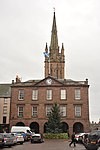
Montrose Town House Montrose , High Street NO7145257791 56°42′39″N 2°28′05″W / 56.710935°N 2.467934°W / 56.710935; -2.467934 (Montrose Town House ) 18th-century municipal buildings [90] 38083 Upload another image See more images
Montrose Parish Church Montrose , High Street NO7146557756 56°42′38″N 2°28′04″W / 56.710621°N 2.467718°W / 56.710621; -2.467718 (Montrose Parish Church ) Late-18th-century church, with 19th-century spire by James Gillespie Graham [91] 38084 Upload another image See more images
10 Castle Place, Straton House Montrose NO7142157602 56°42′33″N 2°28′06″W / 56.709235°N 2.46842°W / 56.709235; -2.46842 (10 Castle Place, Straton House ) 18th-century town house [92] 38095 Upload Photo Montrose Infirmary Montrose NO7104457439 56°42′28″N 2°28′28″W / 56.707748°N 2.474559°W / 56.707748; -2.474559 (Montrose Infirmary ) 19th-century hospital building by James Collie [93] 38112 Upload another image See more images
1-8 (inclusive nos) Panmure Terrace Montrose NO7165257787 56°42′39″N 2°27′53″W / 56.710911°N 2.464667°W / 56.710911; -2.464667 (1-8 (inclusive nos) Panmure Terrace ) Mid 19th-century Classical terrace of eight houses [94] 38195 Upload another image See more images
St Mary's and St Peter's Episcopal Church Montrose NO7172957772 56°42′39″N 2°27′48″W / 56.710781°N 2.463408°W / 56.710781; -2.463408 (St Mary's and St Peter's Episcopal Church ) Mid 19th-century Gothic Revival church by John Henderson [95] 38204 Upload another image See more images
Chapel Works Montrose NO7187157735 56°42′38″N 2°27′40″W / 56.710457°N 2.461084°W / 56.710457; -2.461084 (Chapel Works ) Textile mills, 1833 with later additions, the largest mills in Angus outside Dundee [96] 38212 Upload another image See more images
Montrose Air Station Building 48 Montrose Airfield NO7179559399 56°43′31″N 2°27′45″W / 56.725401°N 2.462509°W / 56.725401; -2.462509 (Montrose Air Station Building 48 ) Unaltered military aircraft shed built 1914 [97] 38228 Upload another image
Bell Rock Lighthouse Inchcape , offshore from Arbroath NO7616526808 56°25′58″N 2°23′17″W / 56.43286°N 2.388089°W / 56.43286; -2.388089 (Bell Rock Lighthouse ) Lighthouse built 1811 by Robert Stevenson [98] 45197 Upload another image See more images
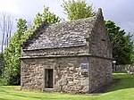
Logie Schoolhouse, Former U.F. Church Logie NO6980863554 56°45′45″N 2°29′44″W / 56.762602°N 2.495469°W / 56.762602; -2.495469 (Logie Schoolhouse, Former U.F. Church ) Later-18th- or early-19th-century vernacular school house, later used as a church [99] 50209 Upload Photo