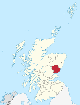
Angus is one of the 32 local government council areas of Scotland, a registration county and a lieutenancy area. The council area borders Aberdeenshire, Dundee City and Perth and Kinross. Main industries include agriculture and fishing. Global pharmaceuticals company GSK has a significant presence in Montrose in the east of the county.

Aberlemno is a parish and small village in the Scottish council area of Angus. It is noted for three large carved Pictish stones dating from the 7th and 8th centuries AD ; the stones can be viewed at any time in spring-autumn, but are covered by wooden boxes in the winter to prevent frost damage. Two stones stand by the B9134 Forfar-Brechin road, the Kirkyard Stone stands in the nearby graveyard of the parish church.

East Haven is a fishing village in the council area of Angus, Scotland. It is situated 1.5 miles (2 km) east of Carnoustie and 5 miles (8 km) south west of Arbroath. The closest city, Dundee, is 13 miles (21 km) to the west.

Brechin is a station in Angus, on the Caledonian Railway line.

Guthrie is a village in Angus, Scotland, roughly at the centre point of the towns of Arbroath, Brechin and Forfar. The principal building in the village is Guthrie Castle. The village of Guthrie is centered on the Guthrie parish church, containing the Guthrie Aisle, built in 1450. The parish was united with Carbuddo in the sixteenth century.
Inverkeilor is a village and parish in Angus, Scotland. It lies near the North Sea coast, midway between Arbroath and Montrose. The A92 road now bypasses the village.

The Aberdeen Railway was a Scottish railway company which built a line from Aberdeen to Forfar and Arbroath, partly by leasing and upgrading an existing railway.
The Scottish North Eastern Railway was a railway company in Scotland operating a main line from Perth to Aberdeen, with branches to Kirriemuir, Brechin and Montrose. It was created when the Aberdeen Railway amalgamated with the Scottish Midland Junction Railway on 29 July 1856. It did not remain independent for long, for it was itself absorbed by the Caledonian Railway on 10 August 1866.

Unthank is a hamlet in Angus, Scotland. It lies approximately half a mile north-west of Brechin on the B966 Brechin to Edzell road. It used to be a possession of the Barony of Spynie.
Colliston is a roadside hamlet in Angus, Scotland that is four miles north of Arbroath on the A933 Arbroath to Brechin road, in the parish of St Vigeans.

Tannadice is a village in Angus, Scotland that lies on the River South Esk and is 4 miles north of Forfar. The estate of Tannadice was formerly owned by William Neish of Tannadice and Clepington. Jock Neish Scout Centre at Tannadice was built on the family's lands and named for William Neish's grandson.

Lunan is a hamlet in Angus, Scotland, in the parish of the same name, 6 kilometres (3.7 mi) south of Montrose. The hamlet overlooks Lunan Bay, which is itself also a hamlet, at the mouth of the Lunan Water. A 16th-century priest of Lunan church, which is in the hamlet of Lunan Bay, Walter Mill, was one of the last Scottish Protestant martyrs to be burned at St. Andrews. The church itself was rebuilt in 1844. The 15th-century Red Castle, so called from the red sandstone it is built from, is located 500 metres (1,600 ft) to the south of the hamlet, on the south bank of the Lunan Water.
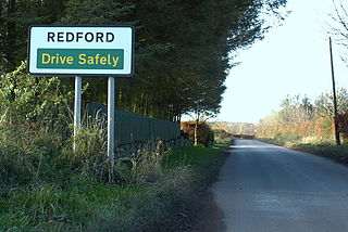
Redford is a hamlet in the parish of Carmyllie in Angus, Scotland. It is situated on high ground between Arbroath, on the coast, and the inland county town of Forfar. Carmyllie school is located in the settlement, as was the old Carmyllie railway station.

Salmond's Muir is a hamlet in the council area of Angus, Scotland. It is situated 2 miles (3 km) north-east of Carnoustie and 4 miles (6 km) west of Arbroath on the A92 road. The junction of the A92 at Salmond's Muir forms the main route to the villages of Panbride, East Haven, Balmirmer and Scryne.
Dun is a rural parish in Angus, Scotland. It contains the House of Dun, home of the Erskine family and is a stop on the Caledonian Railway. It is located on the river South Esk, west of Montrose and east of Brechin. In 1785-7 a bridge was built there across the South Esk. The writer Violet Jacob was born at the House of Dun. William Chalmers Burns, a famous Scottish evangelist was born at Dun in 1815.
The Brechin and Edzell District Railway was a local line in Scotland connecting Edzell, then a developing tourist centre, to the nearby main population centre of Brechin, where there was a branch of the Caledonian Railway. The short line opened in 1896, and it was worked by the Caledonian Railway.
The Forfar and Brechin Railway was promoted as a possible alternative main line to part of the Caledonian Railway route between Perth and Aberdeen. It was opened in 1895, having been sold while incomplete to the Caledonian Railway.

Careston railway station served the hamlet of Careston, Angus, Scotland, from 1895 to 1964 on the Forfar and Brechin Railway.
Justinhaugh railway station served the hamlet of Justinhaugh, Angus, Scotland, from 1895 to 1952 on the Forfar and Brechin Railway.

