
Angus is one of the 32 local government council areas of Scotland, a registration county and a lieutenancy area. The council area borders Aberdeenshire, Dundee City and Perth and Kinross. Main industries include agriculture and fishing. Global pharmaceuticals company GSK has a significant presence in Montrose in the north of the county.

A Pictish stone is a type of monumental stele, generally carved or incised with symbols or designs. A few have ogham inscriptions. Located in Scotland, mostly north of the Clyde-Forth line and on the Eastern side of the country, these stones are the most visible remaining evidence of the Picts and are thought to date from the 6th to 9th century, a period during which the Picts became Christianized. The earlier stones have no parallels from the rest of the British Isles, but the later forms are variations within a wider Insular tradition of monumental stones such as high crosses. About 350 objects classified as Pictish stones have survived, the earlier examples of which holding by far the greatest number of surviving examples of the mysterious Pictish symbols, which have long intrigued scholars.

Glamis is a small village in Angus, Scotland, located four miles south of Kirriemuir and five miles southwest of Forfar. It is the location of Glamis Castle, the childhood home of Queen Elizabeth the Queen Mother.

The Sidlaws, also called the Sidlaw Hills and Sidlaw Range, are a range of hills of volcanic origin in the counties of Perthshire and Angus in Scotland that extend for 30 miles (45 km) from Kinnoull Hill, near Perth, northeast to Forfar. Principal peaks within the Sidlaws include Craigowl Hill, Ark Hill and King's Seat.
Strathmore is a strath in east central Scotland running from northeast to southwest between the Grampian mountains and the Sidlaws. It is approximately 50 miles (80 km) long and 10 miles (16 km) wide. Strathmore is underlain by Old Red Sandstone but this is largely obscured by glacial till, sands and gravels deposited during the ice age. Its northeast to southwest alignment is influenced by the underlying geological structure of the area which reflects the dominant Caledonian trend of both the central lowlands and the Highlands of Scotland; its northern margin reflects the presence of the Highland Boundary Fault. Strathmore is fertile and has some of Scotland's best arable farmland, producing soft fruits and cereals.
Saint Fergus was a bishop who worked in Scotland as a missionary.
Newbigging is a village in Angus, Scotland, two miles north-east of Dundee. The name "Newbigging" originally referred to a "new bigging" or "new cottar town" (hamlet). The village is roughly two miles north of Monifieth and east of Dundee, Scotland's fourth city. Some of the earliest history of the local area is represented approximately four kilometres northwest at the village of Eassie, where the Eassie Stone is displayed in a ruined church; this carved Pictish stone is dated prior to the Early Middle Ages.

Meigle is a village in Strathmore, Scotland. It lies in the council area of Perth and Kinross in the Coupar Angus and Meigle ward. The nearest town is Forfar in neighbouring Angus. Other smaller settlements nearby are Balkeerie, Kirkinch and Kinloch. Meigle is accessed from the north and south via the B954 road. In 1971 it had a population of 357.

The Eassie Stone is a Class II Pictish stone of about the mid 8th century AD in the village of Eassie, Angus, Scotland. The stone was found in Eassie burn in the late 18th century and now resides in a purpose-built perspex building in the ruined Eassie church.
Eassie is a village located along the A94 road in Angus, Scotland. The church in Eassie is dedicated to Saint Fergus, a monk who worked at nearby Glamis. Eassie is noted for the presence of the Eassie Stone, a carved Pictish stone.
Castleton, officially Castleton Of Eassie, is a village in Angus, Scotland. This settlement is situated along the A94 road between Glamis and Meigle. One mile to the south is the village of Eassie noted for the presence of the Eassie Stone; this carved Pictish stone is dated prior to the Early Middle Ages. Slightly further to the south lies Ark Hill within the Sidlaw Hills.

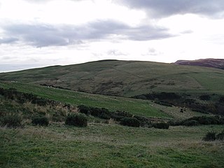
Ark Hill is a mountainous landform within the Sidlaw Hills in Angus, Scotland. This location has been proposed as a windfarm for generating renewable electrical power. Approximately two kilometres to the north is the village of Eassie noted for the presence of the Eassie Stone; this carved Pictish stone is dated prior to the Early Middle Ages.
Balkeerie is a village in Angus, Scotland north of Dundee. It has an elevation of 222 feet (68 m) above sea level. It is one mile (1.6 km) to the north east of kirkinch and two-thirds of a mile (1.1 km) to the west of the village of Eassie. Eassie is noted for the presence of the Eassie Stone, a carved Pictish stone.
Kirkinch, meaning 'kirk (church) on the island' in Scots and Gaelic, is a small village in Angus, Scotland. The 'island' is the knoll on which remains of the medieval church of the parish of Nevay, now united with Eassie, stand. Originally it was an 'island' of slightly higher land surrounded by boggy country. The village houses are adjacent to the knoll, which is encompassed by the wall of the old churchyard. Some of the earliest history of the local area is represented approximately two kilometres northwest at the village of Eassie, where the Eassie Stone is displayed in a modern transparent shelter in the ruined former parish church; this finely carved Pictish cross-slab probably dates to the first half of the 8th century. The church site at Kirkinch is itself probably of early Christian origin. A simple disc-headed cross-slab found here is on display at the Meffan Institute in Forfar.
Milton is a hamlet in Angus, Scotland situated near Glamis. Considerable early history is in the general area including Glamis Castle and the Eassie Stone, a carved Pictish stone dating prior to the Early Middle Ages.
The B954 road is a public highway in Angus, Scotland which generally runs north to south, connecting the settlement of Dykends to the northwestern part of the city of Dundee. The road runs near the Meigle Museum, where a collection of Pictish stones is exhibited, and somewhat to the west of the Eassie Stone, a Pictish stone dating to about 600 AD. The road has been a subject of public controversy, having undergone debate over its speed limit; in particular, a speed limit of 30 to 40 miles per hour was considered to protect pedestrian safety, particularly for children crossing the highway. The proposal was not adopted at the 16 September 2008 meeting.

Kinloch is a small settlement along the A94 road in the Coupar Angus and Meigle ward of the council area of Perth and Kinross in eastern Scotland. Approximately 4 1⁄2 miles (7.2 km) to the east is the village of Eassie noted for the presence of the Eassie Stone; this carved Pictish stone is dated prior to the Early Middle Ages.
Newtyle Hill is a mountainous landform in the Sidlaw Hills in Angus, Scotland The vicinity has elements of prehistory including presence of the Eassie Stone, a Pictish stone dating to the Dark Ages.
Hatton Hill is a mountain landform in Angus, Scotland and is the most easterly peak of the Sidlaw Hills. Hatton Castle stands on the flanks of Hatton Hill above the village of Newtyle. The general vicinity has elements of prehistory including presence of the Eassie Stone, a Pictish stone dating back to the Dark Ages.
Kilry Glen, in Angus, Scotland, is the glen of the Burn of Kilry, a tributary of the River Isla. It is situated west of the B954 road, approximately four miles north of Alyth.

