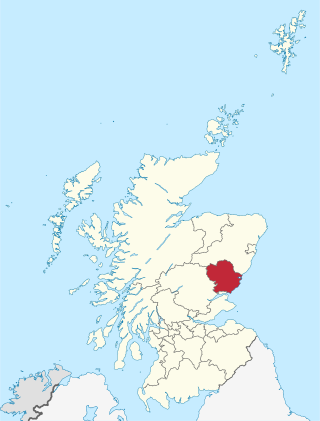
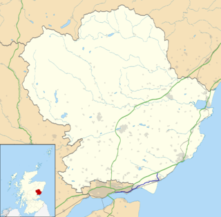
Angus is one of the 32 local government council areas of Scotland, a registration county and a lieutenancy area. The council area borders Aberdeenshire, Dundee City and Perth and Kinross. Main industries include agriculture and fishing. Global pharmaceuticals company GSK has a significant presence in Montrose in the north of the county.

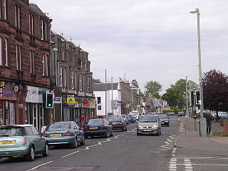
Carnoustie is a town and former police burgh in the council area of Angus, Scotland. It is at the mouth of the Barry Burn on the North Sea coast. In the 2011 census, Carnoustie had a population of 11,394, making it the fourth-largest town in Angus. The town was founded in the late 18th century, and grew rapidly throughout the 19th century due to the growth of the local textile industry. It was popular as a tourist resort from the early Victorian era up to the latter half of the 20th century, due to its seaside location, and is best known for the Carnoustie Golf Links course that often hosts the Open Championship.
Monifieth is a town and former police burgh in the council area of Angus, Scotland. It is situated on the north bank of the Firth of Tay on the east coast. In 2016, the population of Monifieth was estimated at 8,110, making it the fifth largest town in Angus.
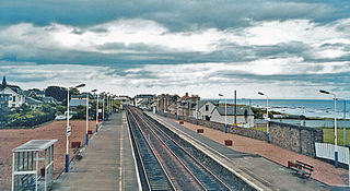
Carnoustie railway station is a railway station which serves the town of Carnoustie, Angus, Scotland. It is sited 10 miles 33 chains (16.8 km) east of the former Dundee East station, on the Dundee to Aberdeen line, between Golf Street and Arbroath. There is a crossover at the south end of the station, which can be used to facilitate trains turning back if the line north to Arbroath is blocked. ScotRail manage the station and provide almost all services.
Barry is a small village in Angus, Scotland, on Barry Burn at the mouth of the River Tay. The recent completion of a bypass for the village on the A930 road from Dundee to Carnoustie is something that was originally planned before the Second World War. There is a water mill operated by the National Trust for Scotland.
The A930 is a single carriageway road in Angus, Scotland. It runs from Dundee to Carnoustie.
The Battle of Barry is a legendary battle in which the Scots, purportedly led by Malcolm II, defeated a Danish invasion force in 1010 AD. Its supposed site in Carnoustie, Angus can be seen in early Ordnance Survey maps. The history of the event relies heavily on tradition and it is considered to be apocryphal. The battle was named for the Parish of Barry, rather than the village, and was formerly thought to have taken place at the mouth of the Lochty burn, in the vicinity of the area that is now occupied by Carnoustie High Street. While the battle is not historically authentic, its romantic appeal continues to capture the popular imagination.

Thomas Lowson is traditionally thought to be the founder of the town of Carnoustie, Angus.
Camus, in historic literature, was a Scandinavian general dispatched to engage the Scots in battle, reportedly in the early eleventh century AD. The legendary engagement was called the Battle of Barry, and was first alluded to by Boece.
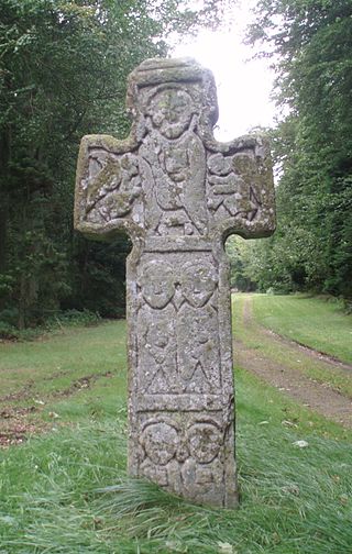
The Camus Cross, otherwise known as the Camuston or Camustane Cross, is an Early Medieval Scottish standing stone on the Panmure Estate near Carnoustie in Angus, Scotland. First recorded in the 15th century in a legal document describing the boundaries between Camuston and the barony of Downie, and described in the 17th century by Robert Maule, it is a freestanding cross, rare in Eastern Scotland.

Muirdrum is a small village in the council area of Angus, Scotland. It is situated at the junction of the old A92 road from Dundee to Arbroath, the A930 to Carnoustie and B9128 to Forfar. Its closest town is Carnoustie, which lies approximately 2 km (1 mi) to the south.
Upper Victoria is a hamlet in Angus, Scotland. It lies on the A92 road between Arbroath and Dundee and is the location of the junction of the A92 and the Marches, the Craigton to Carnoustie road, forming the main route into Carnoustie.
Inverpeffer was a hamlet that once existed in Angus, Scotland until around 1941, when it was demolished during the building of East Haven airfield.
Gardynebourg was a hamlet that once existed in Angus, Scotland, between Barry and Carnoustie. Urban growth in the latter part of the nineteenth century and early twentieth century gradually led to Gardynebourg becoming subsumed into the town of Carnoustie.
Hunter's Town was a hamlet that once existed in Angus, Scotland, between Barry and Carnoustie. Urban growth in the latter part of the nineteenth century and early twentieth century gradually led to Hunter's Town becoming subsumed into the town of Carnoustie.
Carlogie is a hamlet in Angus, Scotland. It lies approximately half a mile north of Carnoustie on the A930 road. Carlogie House was erected in 1854 as the residence of the factor of Panmure Estate. It was converted into a hotel in the 1960s by James Robson. Planning consent was granted to convert it into residential housing in 2007.

Clayholes is a small hamlet in Angus, Scotland. It lies approximately 0.5 kilometres (0.31 mi) north of Carnoustie on the unclassified Balmachie road, that connects the A930 road in Carnoustie with the A92 road at Balmachie.

The Barony of Craigie is a Scottish feudal Crown barony within and near Dundee in Scotland. Craigie has long been incorporated within the boundaries of the Royal Burgh of Dundee; before that it was a barony lying on the periphery of the town.

Carnoustie High School is a comprehensive secondary school in Carnoustie, Angus, Scotland. Situated to the north of the town, the school serves Carnoustie and surrounding villages, including Barry, Monikie, Newbigging, Craigton, Muirdrum, Panbride and Easthaven.

