Inverarity

Last updated
Inverarity
Angus UK location map.svg
Red pog.svg
Inverarity
Inverarity shown within Angus
OS grid reference NO450441
Council area
Lieutenancy area
Country Scotland
Sovereign state United Kingdom
Post town FORFAR
Postcode district DD8
Dialling code 01307
Police Scottish
Fire Scottish
Ambulance Scottish
EU Parliament Scotland
UK Parliament
Scottish Parliament
List of places
UK
Scotland
56°35′08″N2°53′49″W / 56.585582°N 2.897047°W / 56.585582; -2.897047 Coordinates: 56°35′08″N2°53′49″W / 56.585582°N 2.897047°W / 56.585582; -2.897047

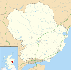
Inverarity is a village in Angus, Scotland, UK, on the A90, 6 miles from Forfar, and 7 miles from Dundee. [1] The nearest villages are Gateside, Invereighty, Kincaldrum and Gallowfauld. Inverarity used to be in the old county of Forfarshire. Its name means "creek of Arity".

Angus, Scotland Council area of Scotland

Angus is one of the 32 local government council areas of Scotland, a registration county and a lieutenancy area. The council area borders Aberdeenshire, Dundee City and Perth and Kinross. Main industries include agriculture and fishing. Global pharmaceuticals company GSK has a significant presence in Montrose in the north of the county.

Forfar town in in Angus, Scotland

Forfar is the county town of Angus, Scotland and the administrative centre for Angus Council. It has a population of 14,048.

Dundee City and council area

Dundee is Scotland's fourth-largest city and the 51st-most-populous built-up area in the United Kingdom. The mid-year population estimate for 2016 was 148,270, giving Dundee a population density of 2,478/km2 or 6,420/sq mi, the second-highest in Scotland. It lies within the eastern central Lowlands on the north bank of the Firth of Tay, which feeds into the North Sea. Under the name of Dundee City, it forms one of the 32 council areas used for local government in Scotland.

Inverarity's first parish church dates from 1243; a replacement was built in 1754.

Inverarity Kirk Inverarity kirk.jpg
Inverarity Kirk

See also

Related Research Articles

East Haven, Angus village in the United Kingdom

East Haven is a fishing village in the council area of Angus, Scotland. It is situated 1.5 miles (2 km) east of Carnoustie and 5 miles (8 km) south west of Arbroath. The closest city, Dundee, is 13 miles (21 km) to the west.

Cortachy Village in Angus, Scotland

Cortachy is a village in Angus, Scotland. It lies in at the mouth of Glen Clova, on the River South Esk, four miles north of Kirriemuir. Nearby lies Cortachy Castle, seat of the Earls of Airlie.

Farnell, Angus village in the United Kingdom

Farnell is a village in Angus, Scotland. It lies 2 miles south of the River South Esk, between Brechin and Montrose, near Kinnaird Castle.

Letham, Angus village in the United Kingdom

Letham is a village in Angus, Scotland.

Boddin, Angus village in United Kingdom

Boddin is a coastal village in Angus, Scotland, two miles south of Montrose.

Oathlaw village in the United Kingdom

Oathlaw is a village in Angus, Scotland, 4 miles north of Forfar.

Old Balkello village in United Kingdom

Old Balkello is a village in Angus, Scotland, three miles north of Dundee on the Auchterhouse to Tealing road.

Caldhame village in United Kingdom

Caldhame is a village in Angus, Scotland. It lies approximately 1 mile to the south of Forfar.

Boysack village in United Kingdom

Boysack is a village in Angus, Scotland, four miles north of Arbroath.

Balkeerie village in United Kingdom

Balkeerie is a village in Angus, Scotland north of Dundee. It has an elevation of 222 feet (68 m) above sea level. It is one mile (1.6 km) to the north east of kirkinch and two-thirds of a mile (1.1 km) to the west of the village of Eassie. Eassie is noted for the presence of the Eassie Stone, a carved Pictish stone.

Tannadice, Angus village in United Kingdom

Tannadice is a village in Angus, Scotland that lies on the River South Esk and is 4 miles north of Forfar. The estate of Tannadice was formerly owned by William Neish of Tannadice and Clepington. Jock Neish Scout Centre at Tannadice was built on the family's lands and named for William Neish's grandson.

Kingsmuir village in United Kingdom

Kingsmuir is a small village in Angus, one mile south-east of Forfar on the B9128 Carnoustie to Forfar road.

Kingennie village in United Kingdom

Kingennie is a village in Angus, Scotland, two miles north of Monifieth. It is mostly known for the Forbes Of Kingennie holiday and golf resort.

Ardovie village in United Kingdom

Ardovie is a settlement on the perimeter of Montreathmont Moor, 3 miles south of Brechin.

Inveraldie village in United Kingdom

Inveraldie is a village in Angus, Scotland. It lies on the north-bound side of the A90 road, two miles north of Dundee.

Bridgefoot, Angus village in United Kingdom

Bridgefoot, previously called Kirkton of Strathmartine, is a village in Angus, Scotland. It lies approximately one mile north of Dundee, to the west of Strathmartine Hospital.

Wellbank village in the United Kingdom

Wellbank is a village in Angus, Scotland. It lies approximately three miles north of Dundee, on the B978 road.

Kirkton of Kingoldrum village in United Kingdom

Kirkton of Kingoldrum is a village in Angus, Scotland. It lies in approximately four miles west of Kirriemuir on the B951 road.

Gallowfauld human settlement in United Kingdom

Gallowfauld is a hamlet in the county of Angus, Scotland. It lies 3.8 miles (6.1 km) south of Inverarity, Angus, Scotland.

References

  1. "Dundee and Montrose, Forfar and Arbroath", Ordnance Survey Landranger Map (B2 ed.), 2007, ISBN   0-319-22980-7