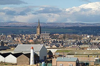
Montrose is a town and former royal burgh in Angus, Scotland. Situated 38 miles north of Dundee and 42 miles south of Aberdeen, Montrose lies between the mouths of the North and South Esk rivers. It is the northernmost coastal town in Angus and developed as a natural harbour that traded in skins, hides and cured salmon in medieval times.

Montrose Basin is a nearly circular tidal basin which makes up part of the estuary of the River South Esk and which sits just inland of the town of Montrose in Angus on the east coast of Scotland. The basin is protected by a number of designations, it is managed by the Scottish Wildlife Trust as a Wildlife Reserve, as well as being designated as a Local Nature Reserve, Site of Special Scientific Interest, a Special Protection Area and a Ramsar Site.
The River Esk, also called the Lothian Esk, is a river that flows through Midlothian and East Lothian, Scotland.

Ainthorpe is a village in the civil parish of Danby and the Scarborough district of the county of North Yorkshire, England. It is situated within the North York Moors National Park in the Esk Valley, a quarter of a mile south of Danby and 12 miles (19 km) west of Whitby.

The House of Dun is a National Trust for Scotland property in the parish of Dun, lying close to the edge of Montrose Basin and situated approximately half way between the towns of Montrose and Brechin, in Angus, Scotland.

Charltons is a village in the borough of Redcar and Cleveland and the ceremonial county of North Yorkshire, England.

Dunbeg, formerly known as Dunstaffnage, is a village about 2 1⁄2 miles (4 km) outside of Oban, Scotland. It has a population of just under 1,000. It is home to the Scottish Association for Marine Science (SAMS), one of the primary marine science centres in the UK. Also near Dunbeg is Dunstaffnage Castle, part of the Campbell Clan and is owned by the Captain of Dunstaffnage.

Cortachy is a village in Angus, Scotland. It lies in at the mouth of Glen Clova, on the River South Esk, four miles north of Kirriemuir. Nearby lies Cortachy Castle, seat of the Earls of Airlie.
William Yolland CB, FRS FRSA was an English military surveyor, astronomer and engineer, and was Britain's Chief Inspector of Railways from 1877 until his death. He was a redoubtable campaigner for railway safety, often in the face of strong opposition, at a time when railway investment was being directed towards the expansion of the networks rather than the prevention of accidents. He was a member of the three-man committee of inquiry into the Tay Bridge disaster.
Farnell is a village in Angus, Scotland. It lies 2 miles south of the River South Esk, between Brechin and Montrose, near Kinnaird Castle.
Eden Water is a tributary of the River Tweed in the Scottish Borders of Scotland. "Water" is the Lowland Scots term for a small river.

Gladhouse Reservoir, formerly known as Moorfoot Loch, is a reservoir in Midlothian, Scotland, five miles (8 km) south of Penicuik. It is the most southerly reservoir in Midlothian, as well as being the largest area of freshwater in the Lothians. It is used to supply Edinburgh with drinking water.
Clova is a village in Glen Clova, Angus, Scotland. It lies on the River South Esk, some 12 miles north of Kirriemuir.
Milton of Finavon is a hamlet in Angus, Scotland that lies adjacent to the A90 road on its southern side by the River South Esk. It is approximately 5 miles north-east of Forfar.
Craigo is a village in Angus, Scotland. It lies about 5 miles (8.0 km) northwest of Montrose, and 1 mile (1.6 km) south of Marykirk, which is across the River North Esk in Aberdeenshire. Craigo developed in the 19th century as a textile village.
The North British, Arbroath and Montrose Railway was a company established by Act of Parliament in 1871 to construct and operate a railway line from north of Arbroath via Montrose to Kinnaber Junction, 38 miles (61 km) south of Aberdeen. The company was originally a subsidiary of the North British Railway but it was absorbed into its parent in 1880. Construction of the line was delayed and a viaduct had to be dismantled and rebuilt following the Tay Bridge disaster. Rivalry between the companies on the east and west coast routes from London to Aberdeen, the "Race to the North", culminated in 1895 – the crucial point was at Kinnaber Junction where the two routes converged into a single railway.
Gallow Hill is one of the hills of the Sidlaw range in South East Perthshire, Scotland. At 378 metres (1,240 ft). Gallow Hill is located near Newbigging and is smaller than Craigowl Hill.
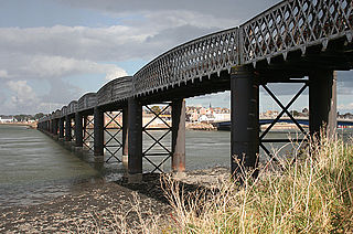
Ferryden is a village in Angus, Scotland in the community council area of Ferryden & Craig. It lies southerly adjacent to the town of Montrose on the south bank of the South Esk and is considered a fringe locality of Montrose, being connected to the latter by the former Rossie Island, now home to shipping facilities and Montrose Port Authority.
