Ferryden

Last updated

Ferryden
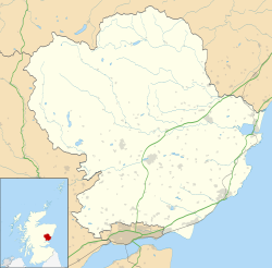
Angus UK location map.svg
Red pog.svg
Ferryden
Location within Angus
Area0.26 km2 (0.10 sq mi)
Population1,220 (mid-2020 est.) [1]
  Density 4,692/km2 (12,150/sq mi)
Demonym Ferrydenner
OS grid reference NO7156
Council area
Lieutenancy area
Country Scotland
Sovereign state United Kingdom
Post town Montrose
Postcode district DD10
Police Scotland
Fire Scottish
Ambulance Scottish
UK Parliament
Scottish Parliament
List of places
UK
Scotland
56°41′N2°28′W / 56.69°N 2.47°W / 56.69; -2.47

Ferryden is a village in Angus, Scotland in the community council area of Ferryden & Craig. It lies southerly adjacent to the town of Montrose on the south bank of the South Esk and is considered a fringe locality of Montrose, being connected to the latter by the former Rossie Island, now home to shipping facilities and Montrose Port Authority.

Contents

Pier at Ferryden Small pier, Ferryden - geograph.org.uk - 1544097.jpg
Pier at Ferryden
South bank of the South Esk at Ferryden South Esk, Ferryden - geograph.org.uk - 1544071.jpg
South bank of the South Esk at Ferryden

History

Ferryden owes its name to the ferry crossing that crossed the South Esk river to and from Montrose, with the earliest record of a ferry crossing being recorded in 1178 when King William the Lion granted the ferryboat of Montrose and its lands to Arbroath Abbey. The village itself began to grow in the 1700s when fishermen from the North East were encouraged to settle by Patrick Scott of Rossie. [2]

Geography

Ferryden was joined to Rossie Island, a former island at the mouth of the South Esk in the late 20th century by infilling. [3] The 1911 Encyclopædia Britannica lists the population of the island (160) as separate from the village of Ferryden (1330): [4]

In the mouth of the channel of the South Esk lies the island of Rossie, or Inchbrayock (pop. 160), which in 1829 was connected with the burgh by means of a suspension bridge 432 ft. long and by a drawbridge with the south bank near the fishing village of Ferryden (pop. 1330). The harbour lies between the suspension bridge and the sea, and is provided with a wet dock. [4]

Usan Road junction, Ferryden Usan Road, Ferryden approaching its junction with Southesk Place and Brownlow Place - geograph.org.uk - 1204196.jpg
Usan Road junction, Ferryden

Facilities

There is one school in the village, namely Ferryden Primary School on Craig Crescent.

Related Research Articles

<span class="mw-page-title-main">Aberdour</span> Human settlement in Scotland

Aberdour is a scenic and historic village on the south coast of Fife, Scotland. It is on the north shore of the Firth of Forth, looking south to the island of Inchcolm and its Abbey, and to Leith and Edinburgh beyond. According to the 2011 census, the village has a population of 1,633.

<span class="mw-page-title-main">Firth of Forth</span> Estuary of Scotlands River Forth

The Firth of Forth is the estuary, or firth, of several Scottish rivers including the River Forth. It meets the North Sea with Fife on the north coast and Lothian on the south.

<span class="mw-page-title-main">Brodick</span> Village in Scotland

Brodick is the main village on the Isle of Arran, in the Firth of Clyde, Scotland. It is halfway along the east coast of the island, in Brodick Bay below Goat Fell, the tallest mountain on Arran. The name is derived from the Norse "breda-vick" meaning "Broad Bay".

<span class="mw-page-title-main">Montrose, Angus</span> Town and former Royal burgh in Scotland

Montrose is a town and former royal burgh in Angus, Scotland. Situated 28 miles north of Dundee and 37 miles south of Aberdeen, Montrose lies between the mouths of the North and South Esk rivers. It is the northernmost coastal town in Angus and developed as a natural harbour that traded in skins, hides, and cured salmon in medieval times.

<span class="mw-page-title-main">River Exe</span> River in Devon and Somerset, England

The River Exe in England rises at Exe Head, near the village of Simonsbath, on Exmoor in Somerset, 5.2 miles (8.4 km) from the Bristol Channel coast, but flows more or less directly due south, so that most of its length lies in Devon. It flows for 60 miles (96 km) and reaches the sea at a substantial ria, the Exe Estuary, on the south coast of Devon. Historically, its lowest bridging point was the Old Exe Bridge in Exeter, the largest settlement on the river, but there is now a viaduct for the M5 motorway about 2 miles (3.2 km) south of the city centre.

<span class="mw-page-title-main">Limekilns</span> Human settlement in Scotland

Limekilns is a village in Fife, Scotland. It lies on the shore of the Firth of Forth, around 3 miles (5 km) south of Dunfermline.

<span class="mw-page-title-main">Port Bannatyne</span> Human settlement in Scotland

Port Bannatyne, is a coastal village on the Isle of Bute, Firth of Clyde, Scotland that is home to many steamers. Port Bannatyne developed into the 1900s as a quieter alternative to Rothesay. It is a popular harbour, with a small yacht marina and boatyard and an unusual 13-hole golf course rather than the standard 18.

<span class="mw-page-title-main">Musselburgh</span> Town in East Lothian, Scotland

Musselburgh is the largest settlement in East Lothian, Scotland, on the coast of the Firth of Forth, 5 miles (8 km) east of Edinburgh city centre. It has a population of 21,100.

<span class="mw-page-title-main">Angus (UK Parliament constituency)</span> Parliamentary constituency in the United Kingdom, 1997 onwards

Angus is a county constituency of the House of Commons of the Parliament of the United Kingdom. It elects one Member of Parliament (MP) by the first-past-the-post voting system. It is currently represented by Dave Doogan of the Scottish National Party who has been the MP since 2019.

<span class="mw-page-title-main">Port Askaig</span> Human settlement in Scotland

Port Askaig is a port village on the east coast of the island of Islay, in Scotland. The village lies on the Sound of Islay across from Jura.

<span class="mw-page-title-main">Corrie, Arran</span> Human settlement in Scotland

Corrie is a village on the north east coast of the Isle of Arran in Scotland, 6 miles north of Brodick. It lies 2 mi (3 km) due east under the island's highest mountain, Goat Fell. A path from High Corrie 34 mi (1.2 km) to the south, provides access to the hillside. Corrie, and its northern neighbour, Sannox, lie approximately halfway between Brodick and Lochranza.

<span class="mw-page-title-main">Cortachy</span> Village in Angus, Scotland

Cortachy is a village in Angus, Scotland. It lies in at the mouth of Glen Clova, on the River South Esk, four miles north of Kirriemuir. Nearby lies Cortachy Castle, seat of the Earls of Airlie.

<span class="mw-page-title-main">Edward Baird (artist)</span>

Edward Baird was a Scottish artist, known for his portrait painting.

<span class="mw-page-title-main">Cornwall Land District</span> Cadastral in Tasmania, Australia

Cornwall Land District is one of the twenty land districts of Tasmania which are part of the Cadastral divisions of Tasmania. It contains most of Launceston. It was formerly Cornwall County, one of the 18 counties of Tasmania and one of the first eleven proclaimed in 1836. It was named after the then southwestern county of England.

<span class="mw-page-title-main">Ulsta</span> Human settlement in Scotland

Ulsta is a village in the south-west of the island of Yell, Shetland, Scotland. North Ness Hall is the local community facility. The car ferry to Toft on Mainland, Shetland leaves from here.

<span class="mw-page-title-main">Scurdie Ness</span> Lighthouse

Scurdie Ness is a headland located on the South side of the River South Esk estuary, Montrose, Angus, Scotland. The River leads from the North Sea into Montrose Harbour and then into Montrose Basin. The headland has also been referred to as Scurdy Ness, Montrose point or Montroseness. The word Scurdie is a local word for the volcanic rock found there and Ness means a promontory, cape or headland. The coastline from Scurdie Ness to Rickle Craig has been designated a Site of Special Scientific Interest.

<span class="mw-page-title-main">George Buchanan (engineer, born 1790)</span> Scottish civil engineer and land surveyor

George Buchanan FRSE FRSSA was a Scottish civil engineer and land surveyor who worked primarily on bridges and harbours. He supervised the construction of the Scotland Street tunnel and the Granton to Edinburgh tunnel.

<span class="mw-page-title-main">North British, Arbroath and Montrose Railway</span> Railway line in Scotland

The North British, Arbroath and Montrose Railway was a company established by Act of Parliament in 1871 to construct and operate a railway line from north of Arbroath via Montrose to Kinnaber Junction, 38 miles (61 km) south of Aberdeen. The company was originally a subsidiary of the North British Railway but was absorbed into its parent in 1880.

Events from the year 1808 in Scotland.

<span class="mw-page-title-main">St Cyrus National Nature Reserve</span> Scottish nature reserve

St Cyrus National Nature Reserve (NNR) is situated between the village of St Cyrus and the North Sea in the far south of the council area of Aberdeenshire in Scotland. The reserve comprises a narrow strip of land that is 3.5 km long and less than 500 m across at its widest point: the total area is 92 hectares, most of which is only a few metres above sea level and bounded by cliffs to the west. It forms the northern third of Montrose Bay, with the River North Esk marking its southern boundary. The reserve was declared in 1962, and is managed by NatureScot. The cliffs and dunes provide a nationally important habitat for flowering plants and insects, many of which are at their northern limit in Britain. The reserve is one of the most important botanical sites on the north-east coast of Scotland, supporting over 300 plant species.

References

  1. "Mid-2020 Population Estimates for Settlements and Localities in Scotland". National Records of Scotland. 31 March 2022. Retrieved 31 March 2022.
  2. "Boat will promote Ferryden's treasures". The Courier. 14 April 2017. Retrieved 30 December 2022.
  3. "Rossie Island (Inchbraoch)". Gazetteer for Scotland. Retrieved 20 January 2019.
  4. 1 2 Wikisource-logo.svg  Chisholm, Hugh, ed. (1911). "Montrose". Encyclopædia Britannica . Vol. 18 (11th ed.). Cambridge University Press. p. 794.