Botolph Claydon is a hamlet in the civil parish of East Claydon, in Buckinghamshire, England. It is situated about 9 miles (14 km) east of Bicester in Oxfordshire, and 7 miles (11 km) north west of Aylesbury.

Combe Raleigh is a village and civil parish in the county of Devon, England. The village lies about 1.5 miles north of the town of Honiton, and the parish is surrounded, clockwise from the north, by the parishes of Luppitt, Honiton, Awliscombe and Dunkeswell.

Kelmarsh is a village and civil parish in West Northamptonshire, England. The population of the civil parish at the 2011 Census was 208. The village is on the A508, close to its junction with the A14 about 5 miles (8 km) south of Market Harborough and 11 miles (18 km) north of Northampton.

Cornsay is a hamlet and civil parish in County Durham, England. The population of the Civil Parish taken at the 2011 census was 1,128. It is 6 miles (9.7 km) southeast of Consett and 7 miles (11 km) southwest of Durham. It consists of nineteen dwellings, including four farms & is the home of Greenacres nudist club. All formerly belonged to Ushaw College for the training of Catholic priests, hence the organised nomenclature. East and West Farms are now in private hands as homes but the other two are still active, South Farm run by the Suddes family and North Farm by the Tweddle family.

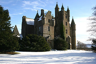
Airlie is a civil parish in the Scottish council area of Angus. It is the seat of the Earl of Airlie, and the location of Airlie Castle. It comprises Craigton of Airlie, Baitland of Airlie and Kirkton of Airlie. There is a standing stone in a field just east of the Baitland; various Pictish and Roman relics have been uncovered and the primary school is reputed to have been built on the site of an old graveyard. Airlie also contains one of the finest examples of a Pictish souterrain in Scotland, with the carving of a snake clearly visible in the ceiling.

Engine Common is a village in the civil parish of Iron Acton in South Gloucestershire, England. It lies about 1 mile north west of Yate.

Broadwoodkelly is a village and civil parish in the West Devon district of Devon, England. According to the 2001 census it had a population of 218. The village is situated about 9 miles (14 km) north of Okehampton.

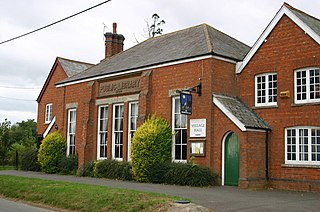
Curtisden Green is a hamlet, lying 3 miles (4.8 km) to the north of Goudhurst, Kent, England. It is the location of Bethany School.

Bridge of Craigisla is a hamlet in Angus, Scotland. The bridge crosses the River Isla. This settlement lies along the B954 road.

Hunsdon is a village and civil parish in Hertfordshire, England. It is around 5.5 miles (9 km) east of Ware and 5 miles (8 km) north-west of Harlow. The population of the village taken at the 2011 Census was 1,080.

Garmond is a linear village in Monquhitter Parish which is located in Aberdeenshire, Scotland. It was founded c.1760. Like the neighbouring villages of Cuminestown and New Byth, the residential part is located on the crest of a hill, the valley below being largely given over to farmland.

Brightwalton Green is a hamlet in the civil parish of Brightwalton in the county of Berkshire, England. The settlement lies near to the A338 road, and is situated approximately 8 miles (13 km) north-west of Newbury.

Eling is a hamlet in the civil parish of Hampstead Norreys in the English county of Berkshire. The settlement lies next to the M4 motorway, and is located approximately 5 miles (8.0 km) north-east of Newbury. The Eling estate was owned by Gerald Palmer and is now administered by a charitable trust.

The A970 is a single-carriageway road that runs from south to north of Mainland Shetland, Scotland. The road also spurs to Scalloway and North Roe.

The Ordnance Survey (OS) is the national mapping agency for Great Britain. The agency's name indicates its original military purpose, which was to map Scotland in the wake of the Jacobite rising of 1745. There was also a more general and nationwide need in light of the potential threat of invasion during the Napoleonic Wars. Since 1 April 2015, the Ordnance Survey has operated as Ordnance Survey Ltd, a government-owned company, 100% in public ownership. The Ordnance Survey Board remains accountable to the Secretary of State for Science, Innovation and Technology. It was also a member of the Public Data Group.
Balintore is a village in Angus, Scotland. It lies in Glen Isla, four miles north of the Loch of Lintrathen and seven miles west of Kirriemuir. Approximately half a mile to the east is Knowehead of Auldallan farm, where there can be found a pair of uninscribed standing stones.

Clova is a village in Glen Clova, Angus, Scotland. It lies on the River South Esk, some 12 miles (19 km) north of Kirriemuir.
Kirkton of Glenisla consists of a church and graveyard, a hotel, hall and several homes forming the largest concentration of habitation in Glenisla, Angus, Scotland. It is situated on the River Isla, eleven miles north-west of Kirriemuir and ten miles north of Blairgowrie, on the B951 road. The kirkton is situated adjacent to the 64 mile waymarked Cateran Trail. There is a suspension footbridge that was built in 1824 over the River Isla.
Brewlands Bridge is a hamlet in Glen Isla, Angus, Scotland. It is lies situated on the River Isla, eleven miles north-west of Kirriemuir and ten miles north of Blairgowrie, on the B951 road.

Little Forter is a hamlet in Glen Isla, Angus, Scotland. It is on the River Isla, 13 miles north-west of Kirriemuir and 11 miles north of Blairgowrie, on the B951 road.

