Kellas, Angus

Last updated

Kellas
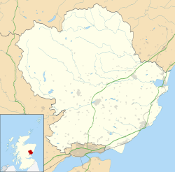
Angus UK location map.svg
Red pog.svg
Location within Angus
OS grid reference NO456354
Council area
Lieutenancy area
Country Scotland
Sovereign state United Kingdom
Post town DUNDEE
Postcode district DD5
Dialling code 01382
Police Scotland
Fire Scottish
Ambulance Scottish
UK Parliament
Scottish Parliament
List of places
UK
Scotland
56°30′27″N2°53′08″W / 56.507502°N 2.885453°W / 56.507502; -2.885453

Kellas is a village in Angus, Scotland. It lies approximately two miles north of Dundee, on the B978 road. [1] [2]
Contents

Bus Services

Bus operator Moffat & Williamson runs services 78 & 79 which serve Kellas on the way to Monifieth, Broughty Ferry and Dundee. [3]

Additionally, on Tuesdays and Thursdays, Service 181A operates, linking Carnoustie and Forfar with several towns, including Kellas and Wellbank. The service is run by JP Minicoaches. [4]

Kellas Kellas - geograph.org.uk - 9992.jpg
Kellas

References

  1. "Dundee and Montrose, Forfar and Arbroath", Ordnance Survey Landranger Map (B2 ed.), 2007, ISBN   0-319-22980-7
  2. "Kellas from The Gazetteer for Scotland". www.scottish-places.info. Retrieved 11 May 2023.
  3. "Services 78A -79C Bus Timetable Dundee - Monikie - Dundee Circulars" (PDF). angus.gov.uk.
  4. "Service 181" (PDF). angus.gov.uk.

Notes