
The Brough of Birsay is an uninhabited tidal island off the north-west coast of The Mainland of Orkney, Scotland, in the parish of Birsay. It is located around 13 miles north of Stromness and features the remains of Pictish and Norse settlements as well as a modern light house.

A Pictish stone is a type of monumental stele, generally carved or incised with symbols or designs. A few have ogham inscriptions. Located in Scotland, mostly north of the Clyde-Forth line and on the Eastern side of the country, these stones are the most visible remaining evidence of the Picts and are thought to date from the 6th to 9th century, a period during which the Picts became Christianized. The earlier stones have no parallels from the rest of the British Isles, but the later forms are variations within a wider Insular tradition of monumental stones such as high crosses. About 350 objects classified as Pictish stones have survived, the earlier examples of which holding by far the greatest number of surviving examples of the mysterious symbols, which have long intrigued scholars.
Glamis is a small village in Angus, Scotland, located 4 miles (6.4 km) south of Kirriemuir and 5 miles (8.0 km) southwest of Forfar. It is the location of Glamis Castle, the childhood home of Queen Elizabeth the Queen Mother.
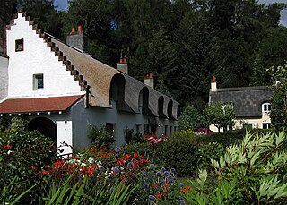
Fortingall is a small village in highland Perthshire, Scotland, in Glen Lyon. Its nearest sizable neighbours are Aberfeldy and Kenmore. Its Gaelic name is Fartairchill.

The Nigg Stone is an incomplete Class II Pictish cross-slab, perhaps dating to the end of the 8th century.

Meigle is a village in Strathmore, Scotland. It lies in the council area of Perth and Kinross in the Coupar Angus and Meigle ward. It lies on the A94 road between Perth and Forfar. Other smaller settlements nearby are Balkeerie, Kirkinch and Kinloch. Meigle is accessed from the north and south via the B954 road. In 1971 it had a population of 357.

Invergowrie is a village on the northwest bank of the Firth of Tay to the west of Dundee. Historically part of Perthshire, it was formerly incorporated as part of the city of Dundee, but is now administered as part of Perth and Kinross.

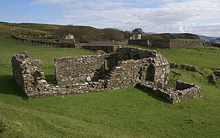
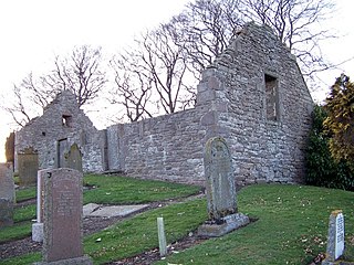
Saddell Abbey is a ruined Cistercian monastery located in western Scotland. The abbey was established in 1160 by Somerled, Lord of Kintyre, who was killed in 1164. The abbey was completed by his son, Ragnall, a few years later. The original layout of the abbey included a church and three adjoining buildings grouped around a cloister. Saddell Abbey is widely known for its important collection of life-sized stone carvings and burial slabs that were constructed from the 14th to the 16th centuries. Historic Environment Scotland established the site as a scheduled monument in 1975.

Logierait is a village and parish in Atholl, Scotland. It is situated at the confluence of the rivers Tay and Tummel, 500 metres west of the A9 road in Perth and Kinross.
Longforgan is a village and parish in the Carse of Gowrie, in Perth and Kinross, Scotland. It lies 5 miles west of Dundee on the main A90 road.

The Eassie Stone is a Class II Pictish stone of about the mid 8th century AD in the village of Eassie, Angus, Scotland. The stone was found in Eassie burn in the late 18th century and now resides in a purpose-built perspex building in the ruined Eassie church.

Wester Denoon is a small settlement in Angus, Scotland. Approximately one mile to the north of Wester Denoon is the village of Eassie, where the Eassie Stone is displayed in a ruined church; this carved Pictish stone is dated prior to the Early Middle Ages. Other nearby settlements are Charleston, Balkeerie and Kirkinch. Two fragments of small Pictish cross-slabs have also been found at Wester Denoon itself. One shows the stylised figure of a woman wearing a long dress or mantle fastened on the breast by a large brooch.
Balkeerie is a village in Angus, Scotland north of Dundee. It has an elevation of 222 feet (68 m) above sea level. It is one mile (1.6 km) to the north east of kirkinch and two-thirds of a mile (1.1 km) to the west of the village of Eassie. Eassie is noted for the presence of the Eassie Stone, a carved Pictish stone.
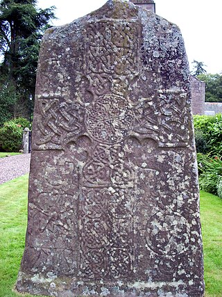
The Glamis Manse Stone, also known as Glamis 2, is a Class II Pictish stone at the village of Glamis, Angus, Scotland. Dating from the 9th century, it is located outside the Manse, close to the parish church. It is inscribed on one side with a Celtic cross and on the other with a variety of Pictish symbols. It is a scheduled monument.
Kirkinner is a village in the Machars, in the historical county of Wigtownshire in Dumfries and Galloway, Scotland. About 3 miles (4.8 km) southwest of Wigtown, it is bounded on the east by the bay of Wigtown, along which it extends for about three miles, and on the north by the river Bladnoch.
The Chapel of St Fyndoca is located on the island of Inishail in Loch Awe, Argyll and Bute, Scotland.

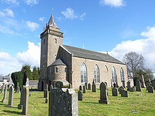
Fowlis Wester is a small village in Perth and Kinross, Scotland. It is around 6 kilometres (3.7 mi) east of Crieff and 19 kilometres (12 mi) west of Perth. The parish of Fowlis Wester includes the Abercairny estate to the south-west.
St. Kenneth's Chapel is a ruined chapel on Inch Kenneth Island, Parish of Kilfinichen and Kilvickeon, Isle of Mull, Argyll and Bute, Scotland. It dates to the 13th century. It became a Scheduled Monument on 27 March 1928.

Anwoth Old Church is a ruined church building which was built in 1626 to serve the parish of Anwoth in Dumfries and Galloway, Scotland. It is roofless, but much of the walls remain, including the west gable which is surmounted by a bellcote. A number of substantial monuments exist within the church and its surrounding churchyard.
.

