The Potomac River drains the Mid-Atlantic United States, flowing from the Potomac Highlands into Chesapeake Bay. It is 405 miles (652 km) long, with a drainage area of 14,700 square miles (38,000 km2), and is the fourth-largest river along the East Coast of the United States and the 21st-largest in the United States. Over 5 million people live within its watershed. There is a hydroelectric plant along the Potomac river constructed in 2014 by Dominion.

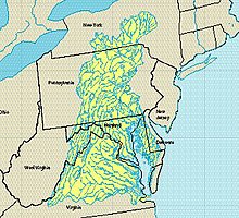
The Chesapeake Bay is the largest estuary in the United States. The Bay is located in the Mid-Atlantic region and is primarily separated from the Atlantic Ocean by the Delmarva Peninsula with its mouth of the Bay at the south end located between Cape Henry and Cape Charles. With its northern portion in Maryland and the southern part in Virginia, the Chesapeake Bay is a very important feature for the ecology and economy of those two states, as well as others surrounding within its watershed. More than 150 major rivers and streams flow into the Bay's 64,299-square-mile (166,534 km2) drainage basin, which covers parts of six states and all of Washington, D.C.

The Delmarva Peninsula, or simply Delmarva, is a large peninsula on the East Coast of the United States, occupied by the vast majority of the state of Delaware and parts of the Eastern Shore regions of Maryland and Virginia. The peninsula is 170 miles (274 km) long. In width, it ranges from 70 miles (113 km) near its center, to 12 miles (19 km) at the isthmus on its northern edge, to less near its southern tip of Cape Charles. It is bordered by the Chesapeake Bay on the west, Pocomoke Sound on the southwest, and the Delaware River, Delaware Bay, and the Atlantic Ocean on the east.

The Eastern Continental Divide, Eastern Divide or Appalachian Divide is a hydrographic divide in eastern North America that separates the easterly Atlantic Seaboard watershed from the westerly Gulf of Mexico watershed. The divide nearly spans the United States from south of Lake Ontario through the Florida peninsula, and consists of raised terrain including the Appalachian Mountains to the north, the southern Piedmont Plateau and lowland ridges in the Atlantic Coastal Plain to the south. Water including rainfall and snowfall, lakes, streams and rivers on the eastern/southern side of the divide drains to the Atlantic Ocean; water on the western/northern side of the divide drains to the Gulf of Mexico. The ECD is one of six continental hydrographic divides of North America which define several drainage basins, each of which drains to a particular body of water.

The Pocomoke River stretches approximately 66 miles (106 km) from southern Delaware through southeastern Maryland in the United States. At its mouth, the river is essentially an arm of Chesapeake Bay, whereas the upper river flows through a series of relatively inaccessible wetlands called the Great Cypress Swamp, largely populated by Loblolly Pine, Red Maple and Bald Cypress. The river is the easternmost river that flows into Chesapeake Bay. "Pocomoke", though traditionally interpreted as "dark water" by local residents, is now agreed by scholars of the Algonquian languages to be derived from the words for "broken ground."
The Wicomico River is a 24.4-mile-long (39.3 km) tributary of the Chesapeake Bay on the eastern shore of Maryland. It drains an area of low marshlands and farming country in the middle Delmarva Peninsula.

The Eastern Shore of Maryland is a part of the U.S. state of Maryland that lies mostly on the east side of the Chesapeake Bay. Nine counties are normally included in the region. The Eastern Shore is part of the larger Delmarva Peninsula that Maryland shares with Delaware and Virginia.

The Choptank River is a major tributary of the Chesapeake Bay and the largest river on the Delmarva Peninsula. Running for 71 miles (114 km), it rises in Kent County, Delaware, runs through Caroline County, Maryland, and forms much of the border between Talbot County, Maryland, on the north, and Caroline County and Dorchester County on the east and south. It is located north of the Nanticoke River, and its mouth is located south of Eastern Bay. Cambridge, the county seat of Dorchester County, and Denton, the county seat of Caroline County, are located on its south shore.

The Severn River is a tidal estuary 14 miles (23 km) long, located in Anne Arundel County in the U.S. state of Maryland, south of the Magothy River and north of the South River.

Mattawoman Creek is a 30.0-mile-long (48.3 km) coastal-plain tributary to the tidal Potomac River with a mouth at Indian Head, Maryland, 20 miles (32 km) downstream of Washington, D.C. It comprises a 23-mile (37 km) river flowing through Prince George's and Charles counties and a 7-mile (11 km) tidal-freshwater estuary in Charles County. About three-fourths of its 94-square-mile (240 km2) watershed lies in Charles County, with the remainder in Prince George's County immediately to the north.
The Nanticoke River is a tributary of the Chesapeake Bay on the Delmarva Peninsula. It rises in southern Kent County, Delaware, flows through Sussex County, Delaware, and forms the boundary between Dorchester County, Maryland and Wicomico County, Maryland. The tidal river course proceeds southwest into the Tangier Sound, Chesapeake Bay. The river is 64.3 miles (103.5 km) long. A 26-mile ecotourism water trail running along the River was set aside in July 2011 by Delaware state and federal officials, contiguous with a 37-mile water-trail extending through Maryland to the Chesapeake Bay.

The Chesapeake Bay Program is the regional partnership that directs and conducts the restoration of the Chesapeake Bay in the United States. As a partnership, the Chesapeake Bay Program brings together members of various state, federal, academic and local watershed organizations to build and adopt policies that support Chesapeake Bay restoration. By combining the resources and unique strengths of each individual organization, the Chesapeake Bay Program is able to follow a unified plan for restoration. The program office is located in Annapolis, Maryland.
The Little Magothy River runs 2.5 miles (4.0 km) through Anne Arundel County in the U.S. state of Maryland. It is located southeast of the Magothy River, just outside its mouth and north of the Severn River.
The Big Annemessex River is a 15.4-mile-long (24.8 km) tributary of the Chesapeake Bay on the Delmarva Peninsula. It rises in Kingston, Somerset County, Maryland, and flows roughly southwest about 6 miles (10 km) in a meandering pattern, then widens into an estuary and continues about 9 miles (14 km) to the bay, near Janes Island State Park. Tributaries include Annemessex Creek, Holland Creek, Hall Creek, Muddy Creek, Colbourn Creek, Jones Creek and Daugherty Creek.
Town Creek is a tributary of the Tred Avon River in Talbot County on Maryland's Eastern Shore.
The Nanjemoy Formation is a geologic formation pertaining to both the Wilcox Group and the Pamunkey Group of the eastern United States, stretching across the states of Virginia, Maryland, and District of Columbia. The formation crops out east of the Appalachians and dates back to the Paleogene period. Specifically to the Ypresian stage of the Eocene epoch, about 55 to 50 Ma or Wasatchian in the NALMA classification, defined by the contemporaneous Wasatch Formation of the Pacific US coast.

The Baltimore, Chesapeake and Atlantic railroad, nicknamed Black Cinders & Ashes, ran from Claiborne, Maryland, to Ocean City, Maryland. It operated 87 miles (140.0 km) of center-line track and 15.6 miles (25.11 km) of sidings. Chartered in 1886, the railroad started construction in 1889 and cost $2.356 million ($2022=71,055,000).