Fort Snelling (unorganized territory)

This list of cemeteries in Minnesota includes currently operating, historical (closed for new interments), and defunct (graves abandoned or removed) cemeteries, columbaria, and mausolea which are historical and/or notable. It does not include pet cemeteries.


Hennepin County is a county in the U.S. state of Minnesota. Its county seat is Minneapolis, the state's most populous city. The county is named in honor of the 17th-century explorer Father Louis Hennepin. The county extends from Minneapolis to the suburbs and outlying cities in the western part of the county. The county's natural areas are covered with extensive woods, hills, and lakes.

Minneapolis–Saint Paul is a metropolitan area in the Upper Midwestern United States centered around the confluence of the Mississippi, Minnesota and St. Croix rivers in the U.S. state of Minnesota. It is commonly known as the Twin Cities after the area's two largest cities, Minneapolis and Saint Paul. Minnesotans often refer to the two together simply as "the cities". The area is Minnesota's economic, cultural, and political center.

Bloomington is a city in Hennepin County, Minnesota, United States, on the north bank of the Minnesota River, above its confluence with the Mississippi River, 10 miles (16 km) south of downtown Minneapolis. At the 2020 census, the city's population was 89,987, making it Minnesota's fourth-largest city.

Nicollet Avenue is a major street in Minneapolis, Richfield, Bloomington, and Burnsville in the U.S. state of Minnesota. It passes through a number of locally well-known neighborhoods and districts, notably Eat Street in south Minneapolis and the traffic-restricted Nicollet Mall in downtown Minneapolis.
Purcell & Elmslie (P&E) was the most widely know iteration of a progressive American architectural practice. P&E was the second most commissioned firm of the Prairie School, after Frank Lloyd Wright. The firm in all iterations was active from 1907 to 1921, with their most famous work being done between 1913 and 1921.

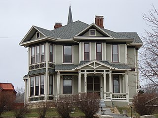
The Gideon H. Pond House is a historic house in Bloomington, Minnesota, United States. It is part of the Pond-Dakota Mission Park, which also includes the Oak Grove Mission site (1843–1852), a cemetery, and the remains of the Pond family farm and orchards. The site is significant within the history of the Minnesota River valley, the Dakota tribe, and Bloomington. The house is listed on the National Register of Historic Places.

This is a list of the National Register of Historic Places listings in Scott County, Minnesota. It is intended to be a complete list of the properties and districts on the National Register of Historic Places in Scott County, Minnesota, United States. The locations of National Register properties and districts for which the latitude and longitude coordinates are included below, may be seen in an online map.

This is a list of the National Register of Historic Places listings in Le Sueur County, Minnesota. It is intended to be a complete list of the properties and districts on the National Register of Historic Places in Le Sueur County, Minnesota, United States. The locations of National Register properties and districts for which the latitude and longitude coordinates are included below, may be seen in an online map.

This is a list of the National Register of Historic Places listings in Murray County, Minnesota.

This is a list of the National Register of Historic Places listings in Big Stone County, Minnesota. It is intended to be a complete list of the properties and districts on the National Register of Historic Places in Big Stone County, Minnesota, United States. Latitude and longitude coordinates are provided for many National Register properties and districts; these locations may be seen together in an online map.

This is a list of the National Register of Historic Places listings in Lac qui Parle County, Minnesota. It is intended to be a complete list of the properties and districts on the National Register of Historic Places in Lac qui Parle County, Minnesota, United States. The locations of National Register properties and districts for which the latitude and longitude coordinates are included below, may be seen in an online map.
Lyndale Avenue is a major street in the U.S. state of Minnesota that traverses the cities of Minneapolis, Brooklyn Center, Richfield, and Bloomington. A noncontiguous portion also exists in Faribault, part of Highway 21. There are several commercial districts along the street, including Lyn-Lake in South Minneapolis, Shops at Lyndale in Richfield, and the Oxboro area in Bloomington. Portions of both Interstate 94 and Interstate 35 run on the right-of-way of Lyndale Avenue.
George W. Orff (1835-1908), was an American architect of Bangor, Maine and Minnesota.

Charles Emlen Bell (1858–1932), often known as C.E. Bell, was an American architect of Council Bluffs, Iowa and Minneapolis, Minnesota. He worked alone and in partnership with John H. Kent and Menno S. Detweiler. He also worked as part of Bell, Tyrie and Chapman. A number of his works are listed on the U.S. National Register of Historic Places.
Long, Lamoreaux & Long was an architectural partnership in Minneapolis, Minnesota, of Franklin B. Long (1842–1912), Lowell A. Lamoreaux, and Franklin's son Louis L. Long.

Fort Snelling is an unorganized territory in the U.S. state of Minnesota. It is named after historic Fort Snelling, which is located within its boundaries. The district also includes Coldwater Spring park, Minneapolis-Saint Paul International Airport, parts of the Mississippi National River and Recreation Area, and several government facilities. As of the 2020 census the territory had a population of 322 people.
Croft & Boerner was an architectural and engineering firm based in Minneapolis, Minnesota, United States. It was a partnership of Francis Boerner (1889–1936) and Ernest Croft (1889–1959). Several of their works are listed on the U.S. National Register of Historic Places for their architecture.

Charles Sumner Sedgwick was an American architect based in Minneapolis, Minnesota.