List of cemeteries in Michigan

Last updated

This list of cemeteries in Michigan includes currently operating, historical (closed for new interments), and defunct (graves abandoned or removed) cemeteries, columbaria, and mausolea which are historical and/or notable. It does not include pet cemeteries.

Contents

Bay County

Gate for Elm Lawn Cemetery in Bay City, Bay County Elm Lawn Cemetery Gate Bay City MI.JPG
Gate for Elm Lawn Cemetery in Bay City, Bay County

Berrien County

Emmet County

Charlevoix County

Genesee County

Houghton County

Ingham County

Kalamazoo County

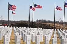
Avenue of Flags at Fort Custer National Cemetery near Augusta, Kalamazoo County Fort Custer National Cemetery - Avenue of Flags.jpg
Avenue of Flags at Fort Custer National Cemetery near Augusta, Kalamazoo County

Kalkaska County

Kent County

Keweenaw County

Copper Harbor Cemetery in Copper Harbor, Keweenaw County Copper Harbor Cemetery.jpg
Copper Harbor Cemetery in Copper Harbor, Keweenaw County

Lenawee County

Livingston County

Macomb County

Mackinac County

Mecosta County

Morgan West Wheatland Cemetery in Wheatland Township, Mecosta County Morgan West Morgan Cemetery.jpg
Morgan West Wheatland Cemetery in Wheatland Township, Mecosta County

Monroe County

Muskegon County

Oakland County

Great Lakes National Cemetery (2009) in Holly, Oakland County Great Lakes National Cemetery.jpg
Great Lakes National Cemetery (2009) in Holly, Oakland County

Roscommon County

St. Clair County

Washtenaw County

Wayne County

Elmwood Chapel at Elmwood Cemetery in Detroit, Wayne County Elmwood Chapel.JPG
Elmwood Chapel at Elmwood Cemetery in Detroit, Wayne County

See also

Related Research Articles

<span class="mw-page-title-main">Keweenaw County, Michigan</span> County in Michigan, United States

Keweenaw County is a county in the western Upper Peninsula of the U.S. state of Michigan. As of the 2020 census, the county's population was 2,046, making it Michigan's least populous county. It is also the state's largest county by total area, including the waters of Lake Superior, as well as the state's northernmost county. The county seat is Eagle River.

<span class="mw-page-title-main">Berrien County, Michigan</span> County in Michigan, United States

Berrien County is a county in the U.S. state of Michigan. It is located at the southwest corner of the state's Lower Peninsula, located on the shore of Lake Michigan and sharing a land border with Indiana. As of the 2020 Census, the population was 154,316. The county seat is St. Joseph.

<span class="mw-page-title-main">Benton Harbor, Michigan</span> City in Michigan, United States

Benton Harbor is a city in Berrien County in the U.S. state of Michigan. It is 46 miles southwest of Kalamazoo and 71 miles southwest of Grand Rapids. According to the 2020 census, its population was 9,103. It is the smaller, by population, of the two principal cities in the Niles–Benton Harbor Metropolitan Statistical Area, an area with 156,813 people. Benton Harbor and the city of St. Joseph are separated by the St. Joseph River and are known locally as the "Twin Cities". Fairplain and Benton Heights are unincorporated areas adjacent to Benton Harbor.

<span class="mw-page-title-main">St. Joseph, Michigan</span> City in Michigan, United States

St. Joseph, colloquially known as St. Joe, is a city and the county seat of Berrien County, Michigan. It was incorporated as a village in 1834 and as a city in 1891. As of the 2020 census, the city population was 7,856. It lies on the shore of Lake Michigan, at the mouth of the St. Joseph River, about 90 miles (140 km) east-northeast of Chicago. It is home of the American Society of Agricultural and Biological Engineers.

<span class="mw-page-title-main">Livonia, Michigan</span> City in Michigan, United States

Livonia is a city in Wayne County, Michigan, United States. A western suburb of Detroit, Livonia is located roughly 20 miles (32.2 km) northwest of downtown Detroit. As of the 2020 census, the city had a population of 95,535. Originally organized as Livonia Township in 1835, it incorporated as a city in 1950.

<span class="mw-page-title-main">America's Most Endangered Places</span> List by the U.S. National Trust for Historic Preservation

America's 11 Most Endangered Places or America's 11 Most Endangered Historic Places is a list of places in the United States that the National Trust for Historic Preservation considers the most endangered. It aims to inspire Americans to preserve examples of architectural and cultural heritage that could be "relegated to the dustbins of history" without intervention.

Saint Andrew's Episcopal Church, or variants thereof, may refer to:

Union Church may refer to:

Cherryville Township is a township in northwestern Gaston County, North Carolina, United States. As of the 2010 census it had a population of 16,500. It includes the incorporated city of Cherryville, the inactive incorporated town of Dellview, the unincorporated community of Tryon, and a portion of the town of High Shoals. It is represented on the Gaston County Board of Commissioners by Allen Fraley of Cherryville.

<span class="mw-page-title-main">Gros Cap Reefs Light</span> Lighthouse

The Gros Cap Reefs Light is a lighthouse located at the entrance to St. Mary's River from Whitefish Bay of Lake Superior. The light was completed in 1953 and replaced a lightship stationed there since 1923. The lighthouse, owned by the Canadian Coast Guard, is located on the southwest edge of the Gros Cap Reef.

References