List of cemeteries in San Bernardino County, California

Last updated

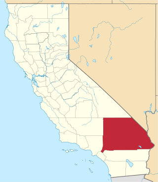
This list of cemeteries in San Bernardino County, California includes currently operating, historical (closed for new interments), and defunct (graves abandoned or removed) cemeteries, columbaria, and mausolea in San Bernardino County, California. It does not include pet cemeteries. Selected interments are given for notable people.

Contents

CemeteryCityCoordinatesNotable intermentsReferences and notes
(U.S. Geological Survey GNIS)
Agua Mansa Pioneer Cemetery Colton 34°02′31″N117°21′50″W / 34.0420°N 117.3639°W / 34.0420; -117.3639 (Agua Mansa Pioneer Cemetery) Early settlers Louis Rubidoux and Cornelius Jensen Agua Mansa Cemetery
Bellevue Cemetery, a.k.a. Bellevue Memorial ParkOntario 34°04′18″N117°21′49″W / 34.0717°N 117.3637°W / 34.0717; -117.3637 (Bellevue Cemetery) Frank F. Ross, recipient of the Medal of Honor during the Spanish–American War.
Founder of Ontario George Chaffey; early Sierra Club President Aurelia Harwood
Bellview Cemetery
Bellevue Memorial Park: History
Calico Cemetery County 34°56′42″N116°52′02″W / 34.9449°N 116.8673°W / 34.9449; -116.8673 (Calico Cemetery) [1] [2]
Campo Santo Cemetery San Bernardino 34°08′24″N117°17′31″W / 34.1400°N 117.2920°W / 34.1400; -117.2920 (Campo Santo Cemetery) Campo Santo Cemetery
Daggett Cemetery Daggett 34°51′31″N116°52′48″W / 34.8586°N 116.8800°W / 34.8586; -116.8800 (Daggett Cemetery) Daggett Cemetery
Desert View Memorial Park Hesperia 34°27′38″N117°21′20″W / 34.4606°N 117.3556°W / 34.4606; -117.3556 (Desert View Memorial Park) Desert View Memorial Park
Fort Mojave Burial Grounds Needles 34°51′06″N114°37′07″W / 34.8517°N 114.6186°W / 34.8517; -114.6186 (Fort Mojave Burial Grounds) Fort Mojave Burial Grounds
Gold Mountain Memorial Park Big Bear City 34°15′05″N116°49′27″W / 34.2514°N 116.8242°W / 34.2514; -116.8242 (Gold Mountain Memorial Park)
Green Acres Memorial Gardens Bloomington 34°02′27″N117°23′11″W / 34.0408°N 117.3864°W / 34.0408; -117.3864 (Green Acres Memorial Gardens) John "Chief" Meyers, Major & Minor League baseball player (1908–20) Green Acres Memorial Gardens
Hermosa Cemetery, a.k.a. Hermosa Gardens CemeteryColton 34°04′34″N117°20′46″W / 34.0761°N 117.3462°W / 34.0761; -117.3462 (Hermosa Cemetery) Western lawman Morgan Earp; MLB players Cam Carreon and Gordon Maltzberger Hermosa Cemetery
Hillside Memorial Park Cemetery Redlands 34°01′30″N117°10′47″W / 34.0250°N 117.1798°W / 34.0250; -117.1798 (Hillside Memorial Park Cemetery) Author Charles Nordhoff; actress Gloria Holden;
television journalist Robert Pierpoint
Hillside Cemetery
City of Redlands: Hillside Memorial Park Cemetery
Holly Cemetery Vidal 34°07′19″N114°30′24″W / 34.1220°N 114.5066°W / 34.1220; -114.5066 (Holly Cemetery) Holly Cemetery
Home of Eternity Cemetery San Bernardino 34°06′50″N117°17′05″W / 34.1139°N 117.2848°W / 34.1139; -117.2848 (Home of Eternity Cemetery) Home of Eternity Cemetery
Indian Cemetery Highland 34°08′57″N117°13′19″W / 34.1492°N 117.2220°W / 34.1492; -117.2220 (Indian Cemetery) Indian Cemetery
Kramer Cemetery Kramer 34°59′44″N117°34′54″W / 34.9955°N 117.5817°W / 34.9955; -117.5817 (Kramer Cemetery) Kramer Cemetery
Montecito Memorial Park Colton 34°02′48″N117°16′39″W / 34.0467°N 117.2775°W / 34.0467; -117.2775 (Montecito Memorial Park) MLB players Dee Fondy, Freddie Fitzsimmons and Ken Hubbs;
actors Lillian Miles and Roy D'Arcy; Congressman Jerry Pettis
Montecito Memorial Park
Mountain Valley Memorial Park Cemetery,
a.k.a. Joshua Tree Memorial Park
Joshua Tree 34°08′03″N116°21′03″W / 34.1342°N 116.3508°W / 34.1342; -116.3508 (Mountain Valley Memorial Park Cemetery) Mountain Valley Memorial Park Cemetery
Mountain View Memorial Park,
a.k.a. Mt. View Cemetery
Barstow 34°55′23″N117°01′26″W / 34.9230°N 117.0239°W / 34.9230; -117.0239 (Mountain View Memorial Park) MLB pitcher Bob Rhoads Mount View Cemetery
Mountain View Cemetery San Bernardino 34°08′21″N117°16′33″W / 34.1392°N 117.2759°W / 34.1392; -117.2759 (Mountain View Cemetery) James Earp, a member of the Earp family; heavy metal guitarist Randy Rhoads Mountain View Cemetery
Our Lady Queen of Peace Catholic Cemetery Loma Linda 34°03′01″N117°17′05″W / 34.0503°N 117.2848°W / 34.0503; -117.2848 (Our Lady Queen of Peace Catholic Cemetery)
Patton State Hospital Highland 34°08′17″N117°12′52″W / 34.1381°N 117.2145°W / 34.1381; -117.2145 (Patton State Hospital)
Pioneer Memorial Cemetery San Bernardino 34°06′48″N117°17′02″W / 34.1133°N 117.2839°W / 34.1133; -117.2839 (Pioneer Memorial Cemetery) Ellis Eames, first mayor of Provo, Utah Pioneer Memorial Cemetery; [3]
Rialto Park Cemetery Rialto 34°06′08″N117°22′33″W / 34.1022°N 117.3759°W / 34.1022; -117.3759 (Rialto Park Cemetery) [4]
Riverview Cemetery Needles 34°49′24″N114°35′55″W / 34.8233°N 114.5986°W / 34.8233; -114.5986 (Riverview Cemetery) Riverview Cemetery
Rodigues Cemetery Victorville 34°36′01″N117°19′50″W / 34.6003°N 117.3306°W / 34.6003; -117.3306 (Rodigues Cemetery) Rodigues Cemetery
Silver Lake CemeteryBaker35.3765940, -116.1117550
Searles Valley Cemetery Trona 35°46′26″N117°22′54″W / 35.7738°N 117.38175°W / 35.7738; -117.38175 (Searles Valley Cemetery)
Sunset Hills Memorial Park Apple Valley 34°33′27″N117°08′34″W / 34.5576°N 117.1427°W / 34.5576; -117.1427 (Sunset Hills Memorial Park) Dale Evans and Roy Rogers [5]
Twentynine Palms Cemetery Twentynine Palms 34°09′15″N116°05′58″W / 34.1542°N 116.0994°W / 34.1542; -116.0994 (Twentynine Palms Cemetery) Twentynine Palms Cemetery
United Islamic Youth Cemetery Adelanto 34°39′25″N117°23′18″W / 34.6569°N 117.3884°W / 34.6569; -117.3884 (United Islamic Youth Cemetery) United Islamic Youth Cemetery ; [6]
Veterans Memorial Park Fontana 34°05′29″N117°25′43″W / 34.0914°N 117.4287°W / 34.0914; -117.4287 (Veterans Memorial Park) Veterans Memorial Park
Victor Valley Memorial Park Victor Valley 34°31′52″N117°17′22″W / 34.5311°N 117.2895°W / 34.5311; -117.2895 (Victor Valley Memorial Park) Golfer Lloyd Mangrum; actor Ned Sparks;
Nolie Murray (founder of Murray's Dude Ranch)
Victor Valley Memorial Park
Wilbur Grave Holcomb Valley 34°18′21″N116°54′01″W / 34.3058°N 116.9003°W / 34.3058; -116.9003 (Wilbur Grave) Wilbur Grave

See also

Footnotes

  1. Peyton, Paige M. (2012). "Ch. 3, Nobody Home: The Deserted Decades". Images of America: Calico. Charleston, SC: Arcadia. p. 68. ISBN   978-0-7385-8905-3.
  2. Steeples, Douglas W. (1999). Treasure from the Painted Hills: A History of Calico, California, 1882–1907. Greenwood Publishing. p. 89. ISBN   0-313-30836-5.
  3. City of San Bernardino: Pioneer Memorial Cemetery
  4. City Treasurer: Rialto Park Cemetery Information and Fees Archived 2014-10-16 at the Wayback Machine
  5. Brooks, Patricia; Brooks, Jonathan (2006). "Chapter 8: East L.A. and the Desert". Laid to Rest in California: a guide to the cemeteries and grave sites of the rich and famous. Guilford, CT: Globe Pequot Press. pp. 235–237. ISBN   978-0762741014. OCLC   70284362.
  6. Hejrat Foundation and Masjid Al-Nabi: Cemetery

Related Research Articles

<span class="mw-page-title-main">San Bernardino County, California</span> County in southern California, United States

San Bernardino County, officially the County of San Bernardino, is a county located in the southern portion of the U.S. state of California, and is located within the Inland Empire area. As of the 2020 U.S. Census, the population was 2,181,654, making it the fifth-most populous county in California and the 14th-most populous in the United States. The county seat is San Bernardino.

<span class="mw-page-title-main">Calico, California</span> Place in California, United States

Calico is a ghost town and former mining town in San Bernardino County, California, United States. Located in the Calico Mountains of the Mojave Desert region of Southern California, it was founded in 1881 as a silver mining town, and was later converted into a county park named Calico Ghost Town. Located off Interstate 15, it lies 3 miles (4.8 km) from Barstow and 3 miles from Yermo. Giant letters spelling CALICO are visible, from the highway, on the Calico Peaks behind it. Walter Knott purchased Calico in the 1950s, and rebuilt all but the five remaining original buildings to look as they did in the 1880s. Calico received California Historical Landmark #782, and in 2005 was proclaimed by then-Governor Arnold Schwarzenegger to be California's Silver Rush Ghost Town.

<span class="mw-page-title-main">Yermo, California</span> Unincorporated community in California, United States

Yermo is an unincorporated community in the Mojave Desert in San Bernardino County, California. It is 13 miles (21 km) east of Barstow on Interstate 15, just south of the Calico Mountains. Its population was estimated at 1,750 in 2009.

<span class="mw-page-title-main">Calico Mountains (California)</span>

The Calico Mountains of California are a mountain range located in the Mojave Desert. The range spans San Bernardino and Inyo counties in California.

<span class="mw-page-title-main">Mojave Road</span> Historical trails and roads

The Mojave Road, also known as Old Government Road, is a historic route and present day dirt road across what is now the Mojave National Preserve in the Mojave Desert in the United States. This rough road stretched 147 miles (237 km) from Beale's Crossing, to Fork of the Road location along the north bank of the Mojave River where the old Mojave Road split off from the route of the Old Spanish Trail/Mormon Road.

<span class="mw-page-title-main">Earp, California</span> Unincorporated community in California, United States

Earp, California is an unincorporated community in San Bernardino County in the Sonoran Desert close to the California/Arizona state line at the Colorado River in Parker Valley.

<span class="mw-page-title-main">National Register of Historic Places listings in Alameda County, California</span>

This is a list of the National Register of Historic Places listings in Alameda County, California.

<span class="mw-page-title-main">National Register of Historic Places listings in San Bernardino County, California</span>

This is a list of the National Register of Historic Places listings in San Bernardino County, California.

<span class="mw-page-title-main">Riverside County, California</span> County in California, United States

Riverside County is a county located in the southern portion of the U.S. state of California. As of the 2020 census, the population was 2,418,185, making it the fourth-most populous county in California and the 10th-most populous in the United States. The name was derived from the city of Riverside, which is the county seat.

<span class="mw-page-title-main">Cedar Lake (California)</span> Reservoir in San Bernardino County, California

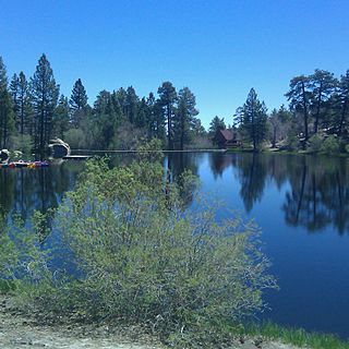
Cedar Lake is an artificial lake in the San Bernardino Mountains of California that has appeared in dozens of Western films. It is the centerpiece of Cedar Lake Camp, a private retreat center owned and operated by Cedar Lake Camp, Inc., a non profit public benefit corporation.

<span class="mw-page-title-main">Agua Mansa, California</span> Ghost town in California, United States of America

Agua Mansa is a former settlement in an unincorporated area of San Bernardino County, near Colton, California, United States. Once the largest settlement in San Bernardino County, it is now a ghost town. Only the cemetery remains.

List table of the properties and districts — listed on the California Historical Landmarks — within San Bernardino County, Southern California.