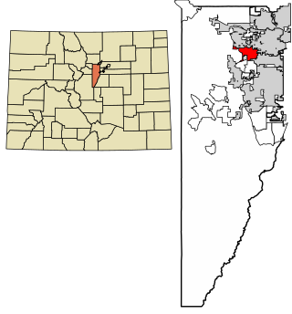
The City of Wheat Ridge is a home rule municipality located in Jefferson County, Colorado, United States. Wheat Ridge is located immediately west of Denver and is a part of the Denver–Aurora–Lakewood, CO Metropolitan Statistical Area. The Wheat Ridge Municipal Center is approximately 5 miles (8 km) west-northwest of the Colorado State Capitol in Denver. The city had a population of 32,398 as of the 2020 Census.
Evergreen Cemetery may refer to the following cemeteries in the United States :

Clear Creek is a tributary of the South Platte River, approximately 66 miles (106 km) long, in north central Colorado in the United States. The creek flows through Clear Creek Canyon in the Rocky Mountains directly west of Denver, descending through a long gorge to emerge at the town of Golden, finally ending in the Colorado Eastern Plains where it joins the South Platte. Clear Creek is unusual in that it is a stream named "creek" fed by a stream named "river"; typically "rivers" are fed by "creeks", and are larger bodies of water, although the nomenclature is ambiguous and there is no clear system. Fall River empties into Clear Creek along I-70 west of Idaho Springs, Colorado.
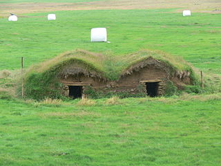
The sod house or soddy was an often used alternative to the log cabin during frontier settlement of the Great Plains of Canada and the United States in the 1800s and early 1900s. Primarily used at first for animal shelters, corrals, and fences, if the prairie lacked standard building materials such as wood or stone, sod from thickly-rooted prairie grass was abundant, free, and could be used for house construction. Prairie grass has a much thicker, tougher root structure than a modern lawn.

Lawrence Cowle Phipps was a United States Senator representing Colorado from 1919 until 1931.
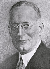
Karl Cortlandt Schuyler was an American attorney and politician from Colorado. A Republican, he was most notable for his service as a United States senator from 1932 to 1933.

The United States Office of Management and Budget has defined the 12-county Denver–Aurora, CO Combined Statistical Area comprising the Denver–Aurora–Lakewood, CO Metropolitan Statistical Area, the Boulder, CO Metropolitan Statistical Area, and the Greeley, CO Metropolitan Statistical Area. The United States Census Bureau estimates that the population was 3,214,218 as of July 1, 2012, an increase of +3.99% since the 2010 United States Census, and ranking as the 16th most populous metropolitan combined statistical area and the 17th most populous primary statistical area of the United States. The population estimate for 2020 was 3,652,385.

The North Central Colorado Urban Area comprises the four contiguous metropolitan statistical areas in the north central region of the State of Colorado: the Denver–Aurora Metropolitan Statistical Area, the Boulder Metropolitan Statistical Area, the Fort Collins-Loveland Metropolitan Statistical Area, and the Greeley Metropolitan Statistical Area. With the exception of southeastern Elbert County, southeastern Park County, and tiny portions of southern Douglas County, the entire North Central Colorado Urban Area is drained by the South Platte River and its tributaries. The North Central Colorado Urban Area is the central, and the most populous, of the three primary subregions of the Front Range Urban Corridor.

Riverside Cemetery, established in 1876, is Denver, Colorado's oldest operating cemetery. More than 67,000 people are buried there, including 1,000 veterans.

The following outline is provided as an overview of and topical guide to the U.S. state of Colorado:

Fairmount Cemetery in Denver, Colorado, was founded in 1890 and is Denver's second oldest operating cemetery after Riverside Cemetery. It is located in land south-east of the intersection of the major Denver roadways Alameda Ave. and Quebec St.. The cemetery was designed by German landscape architect Reinhard Schuetze. The cemetery was patterned after Mount Auburn Cemetery in Cambridge and Watertown, Massachusetts. The cemetery occupies 280 acres (110 ha). The first year the cemetery opened over 4500 trees and shrubs were planted by Schuetze. The cemetery is the largest arboretum in the state.

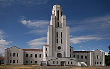
Fairmount Mausoleum is a public mausoleum at Fairmount Cemetery in Denver, Colorado. The building was designed by architects Frederick E. Mountjoy and Francis W. Frewan. Constructed in 1929 and opened in 1930, the Fairmount Mausoleum contains the remains of more than 17,000 people and houses one of the largest stained glass collections in the state of Colorado.
Fairmount is an unincorporated community and a census-designated place (CDP) in Jefferson County, Colorado, United States. The CDP is a part of the Denver–Aurora–Lakewood, CO Metropolitan Statistical Area. The population of the Fairmount CDP was 9,324 at the United States Census 2010. ZIP code 80403 applies to addresses in Fairmount.

The Front Range Urban Corridor is an oblong region of urban population located along the eastern face of the Southern Rocky Mountains, encompassing 18 counties in the US states of Colorado and Wyoming. The corridor derives its name from the Front Range, the mountain range that defines the western boundary of the corridor which serves as a gateway to the Rocky Mountains. The region comprises the northern portion of the Southern Rocky Mountain Front geographic area, which in turn comprises the southern portion of the Rocky Mountain Front geographic area of Canada and the United States. The Front Range Urban Corridor had a population of 5,055,344 at the 2020 Census, an increase of +16.65% since the 2010 Census.
Fort Namaqua, some of its other names are Mariano's Crossing and Namaqua Station, was a trading post from 1858 or 1859. It was located in the present-day city of Loveland, Colorado in Larimer County, Colorado. In 1862, it became a stage station for travelers along the foothills to Denver. A fort was built at the site after 60 horses were driven off the property. Medina also developed a small settlement with people from his hometown of Taos, New Mexico. The site was named Namaqua in 1868, with the establishment of a post office. Buildings were used until the 1920s and were later dismantled. A historical marker is located at Namaqua Park, near the site of the former fort and station. A copper sculpture honors Mariano Medina at the site of the Mariano Medina Family Cemetery.
For references related to individual interments, see articles for the particular individuals.