This is a list of cemeteries in Toronto.
| Name | Location | Dates | Interments | Affiliation | Notes | Image |
|---|---|---|---|---|---|---|
| Armadale Free Methodist Cemetery | Armadale | 1885– | Free Methodist | |||
| Bathurst Lawn Memorial Park | Newtonbrook | 1929– | Jewish |  | ||
| Beth Tzedec Memorial Park | Westminster-Branson | 1949– | 4,414 [1] | Conservative Judaism | Owned by Beth Tzedec Congregation. Westminster Cemetery is located just to the west. |  |
| Bethel Cemetery | Scarborough Junction | 1842 | Non-denominational | |||
| Bingham Family Cemetery | Princess Gardens | 1843–1973 | Closed and graves moved to Riverside Cemetery. Now residential neighbourhood. | |||
| Christ Church St. James Memorial Garden & Cemetery | Mimico | 1832– | 500 | originally Anglican; now non-denominational | Still active [2] |  |
| Christie's Methodist Cemetery | L'Amoreaux | 1846–1926 | Methodist | Today in the parking lot of Bridlewood Mall. | 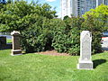 | |
| Dawes Road Cemetery | Clairlea | 1898 | 13,000 [1] | Jewish |  | |
| Duchess Street Burying Ground (Old Scotch Cemetery, Presbyterian Burying Ground) | Moss Park | ~1818–1911 or 1912 | ~263 | Presbyterian (1824–1911) | Linked to Knox Presbyterian Church after 1824, land granted in 1797 and active up to 1840s. The 0.5-acre lot was bounded by Duchess (Richmond) Street to the north, Stonecutters Lane to the east, up to 260 Richmond Street East (Lot 5) to west and Britain Street to the north. Some 263 graves and markers were relocated to Toronto Necropolis in 1911 to 1912 [3] but not all burials recovered as some were found outside the formal boundaries and found after last burials. Built over after closure and now site of commercial buildings with addresses on Richmond and Britain Streets. | |
| Elia United Church Cemetery | Elia | 1832–1957 | United Church of Canada | Cemetery now parking lot but church remains on site. 20 head stones relocated to northside of church lot. | ||
| Emmanuel United Church Cemetery | Malvern | 1868–1933 | United Church of Canada | Cemetery for the village of Malvern. |  | |
| Forest Lawn Mausoleum and Cremation Centre | Willowdale | 1911– | 2400+ | Non-denominational | Owned by Park Lawn Corporation. Crematorium opened in 1980 | |
| Glendale Memorial Gardens | Rexdale | 1952– | Non-denominational | Owned by Arbor Memorial Inc. | ||
| Highland Memory Gardens | Hillcrest | 1953– | 22,000 | Non-denominational | Owned by Arbor Memorial Inc. |  |
| Holy Blossom Memorial Park | Cliffcrest | 1929– | 2449 [1] | Reform Judaism | Owned by Holy Blossom Temple | |
| Islington Burying Grounds | Islington-City Centre West | 1807 | Oldest cemetery in Etobicoke. |  | ||
| Jones Avenue Cemetery | Leslieville | 1883– | 581 [1] | Orthodox Judaism | Second oldest Jewish cemetery in Toronto. |  |
| Knox United Church Cemetery | Agincourt | 1844– | United Church of Canada |  | ||
| Lambton Hills Cemetery | Humber Valley Village | 1910– | 3,271 [1] | Jewish | 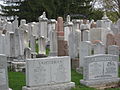 | |
| Lakeshore Psychiatric Hospital Cemetery | Mimico | 1892–1973 | 1525 | Non-denominational |  | |
| McCowan Road Cemetery | Cliffcrest | 1933– | 141 [1] | Orthodox Judaism |  | |
| Melville Presbyterian Cemetery | West Hill | 1852– | Presbyterian | |||
| Mount Hope Catholic Cemetery | Sunnybrook | 1898– | 76,000+ | Roman Catholic | 147 Commonwealth war graves from World War I and II |  |
| Mount Pleasant Cemetery | Moore Park, Toronto/Leaside | 1876– | 168,000 | Non-denominational | Owned by Mount Pleasant Group of Cemeteries |  |
| Mount Sinai Memorial Park | Downsview | 1935– | 8,205 [1] | Jewish | ||
| Pape Avenue Cemetery (Holy Blossom) | Leslieville | 1849–1930s | 293 [1] | Reform Judaism | First Jewish cemetery in Toronto. Owned by Holy Blossom Temple. |  |
| Park Lawn Cemetery | Etobicoke | 1892– | 49,000 | Non-denominational | Owned by Park Lawn Corporation |  |
| Pine Hills Cemetery | Scarborough Junction | 1928– | Non-denominational | Owner by Mount Pleasant Group of Cemeteries |  | |
| Pine Ridge Cemetery | Humber Summit | 1845– | Methodist |  | ||
| Potters Field | Yorkville | 1825–1855 | Non-denominational | First municipal cemetery, also known as the Strangers Burying Ground. Bodies mostly moved to the Necropolis after it was closed. | ||
| Prospect Cemetery | Earlscourt/Fairbank | 1890– | Non-denominational | Owned by Mount Pleasant Group of Cemeteries |  | |
| Resthaven Memorial Gardens | Cliffside | 1925– | 31,000 | Non-denominational | Owned by Arbor Memorial Inc. |  |
| Renforth Baptist Cemetery | Eatonville | 1838– | Baptist | |||
| Richview Memorial Cemetery | Richview | 1853– | United Church of Canada | Today within the cloverleaf of highways 401 and 427. | ||
| Riverside Cemetery | Humber Heights | 1892– | Non-denominational | Owned by Park Lawn Corporation |  | |
| Roselawn Avenue Cemetery | Forest Hill | 1905– | 5,840 [1] | Jewish | ||
| Sanctuary Park Cemetery | Richview | 1927– | Non-denominational | Owned by Park Lawn Corporation |  | |
| Secor Memorial Park | Woburn | 1800s (after 1804) | N/A – see Notes | Family cemetery of the settler Secor family. The Secors are Huguenots should be members of Reformed Church of France, but also married within the Dutch Reformed Church prior to arriving in the area. Today the cemetery is a park with a memorial cairn. | ||
| Sharon Cemetery | Etobicoke | 1845–1955 | Methodist | The Sharon United Church building was demolished in 1967, but the cemetery beside it remains. | ||
| St. Augustine's Seminary Cemetery | Cliffside | 1942 | Roman Catholic |  | ||
| St. James Cathedral Cemetery | St. Lawrence | 1797–1844 | Anglican | Original Anglican cemetery in Toronto. | ||
| St. James Cemetery | St. James Town | 1844– | Non-denominational, originally Anglican |  | ||
| St. John's Cemetery Norway | Upper Beaches | 1853– | 80,000 | Non-denominational, originally Anglican |  | |
| St. John's York Mills | York Mills | 1816– | Anglican | Village cemetery for York Mills. Canadian van Nostrand family monument is located here. |  | |
| St. Michael's Cemetery | Deer Park | 1855– | 29,000 | Roman Catholic | Oldest Catholic cemetery still in service. |  |
| St. Paul Anglican Church, L'Amoreaux | L'Amoreaux | 1840s– | Anglican | Church built in 1841 and burned down 1935 |  | |
| St. Paul's Cemetery | Corktown | 1822–1857 | Roman Catholic | First Catholic cemetery in Toronto. Closed in 1857 and now buried under St. Paul Catholic School play yard on the south side of Queen Street East since 1959. | ||
| Strachan Avenue Military Burying Ground | West of Fort York National Historic Site | 1863–1911 | Approximately 150 soldiers, veterans, their wives and children [4] | Divided into Protestant and Roman Catholic sections |  | |
| Taber Hill | Woburn | 1250 CE (13th Century) | 472 | Iroquois | Burial mound and oldest known burial ground in Toronto now part of a city park (Taber Hill Park) |  |
| Taylor Family | Old East York | c. 1839 | Methodist | Attached to Don Mills United Church. |  | |
| Toronto Necropolis | Cabbagetown | 1850– | 50,000+ | Non-denominational | Owned by Mount Pleasant Group of Cemeteries |  |
| Victoria Memorial Square | Fashion District | 1793–1863 | 400 | N/A – Established as a military by the British Army station in York, Upper Canada | First European cemetery in Toronto. Abandoned and city park since 1880s, 17 markers remaining and restored in 2007–2011 and home to War of 1812 Monument. [5] | 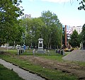 |
| Westminster Cemetery | Westminster-Branson | 1926– | Non-denominational | Owned by Park Lawn Corporation. Beth Tzedek Memorial Park is located just to the east. | ||
| Willowdale Cemetery (Willowdale Methodist Episcopal Cemetery / Cummer Burial Grounds) | North York City Centre | c. 1834 | Methodist/United | Cemetery for the village chapel of Willowdale next to the former Willowdale Methodist Church (later United Church and finally as Seven Day Adventist 1954) that was demolished in 1956. West edge of the cemetery was removed for widening of Yonge Street in 1931 with some families relocating graves to other cemeteries. [6] Cemetery lost much of the northern end beyond Horsham Avenue to a shopping plaza in 1950s. |  | |
| York Cemetery | Willowdale | 1948– | Non-denominational | Owned by Mount Pleasant Group of Cemeteries |  | |
| York Mills Baptist Church Cemetery | 104 York Mills Road | 1833–1945 | 24 | Baptist | Headstones are visible from York Mills Road, and lay protected behind a fence and hedge. Next door, at 106 York Mills Road, is the historic one-story church manse, now a private residence. |