List of communities in Cardiff

Last updated

The communities of Cardiff in 2024. Cardiff UK community map (blank).svg
The communities of Cardiff in 2024.

The City and County of Cardiff is a county in the south-east of Wales. It is one of the 22 principal areas of Wales.

Communities are the lowest tier of local government in Wales. Unlike English counties, which often contain unparished areas, all Welsh principal areas are entirely divided into communities.

There are 36 communities in Cardiff, with Pentyrch being the largest and Grangetown the most populated. Six of them have a community council.

List of communities in Cardiff

CommunityPopulation (2011)Area (km2, 2011)Pre-1974 districtRemarksRefsLocation map
EnglishWelsh
Adamsdown Adamsdown10,3711.07Cardiff County BoroughCommunity without council. [1] 2024 Wales Cardiff Community Adamsdown map.svg
Butetown Tre-biwt10,1255.12Cardiff County BoroughCommunity without council. Includes Flat Holm. [2] 2024 Wales Cardiff Community Butetown map.svg
Caerau Caerau11,3183.03Cardiff County BoroughCommunity without council. [3] 2024 Wales Cardiff Community Caerau map.svg
Canton Treganna14,3043.08Cardiff County BoroughCommunity without council. Includes Pwll-coch and part of Leckwith. [4] 2024 Wales Cardiff Community Canton map.svg
Castle Castell2,1191.72Cardiff County BoroughCommunity without council. [5] 2024 Wales Cardiff Community Castle map.svg
Cathays Cathays18,0021.63Cardiff County BoroughCommunity without council. Includes part of Maindy. [6] 2024 Wales Cardiff Community Cathays map.svg
Cyncoed Cyncoed11,1483.72Cardiff County BoroughCommunity without council. [7] 2024 Wales Cardiff Community Cyncoed map.svg
Ely Trelái14,6032.91Cardiff County BoroughCommunity without council. [8] 2024 Wales Cardiff Community Ely map.svg
Fairwater Y Tyllgoed12,9813.06Cardiff County BoroughCommunity without council. Includes Pentrebane. [9] 2024 Wales Cardiff Community Fairwater map.svg
Gabalfa Gabalfa8,7901.27Cardiff County BoroughCommunity without council. Includes Mynachdy and part of Maindy. [10] 2024 Wales Cardiff Community Gabalfa map.svg
Grangetown Grangetown19,3854.3Cardiff County BoroughCommunity without council. Includes part of Leckwith. [11] 2024 Wales Cardiff Community Grangetown map.svg
Heath Y Mynydd Bychan12,6293.15Cardiff County BoroughCommunity without council. Includes Birchgrove. [12] 2024 Wales Cardiff Community Heath map.svg
Lisvane Llys-faen3,7077.85Cardiff Rural District [13] 2024 Wales Cardiff Community Lisvane map.svg
Llandaff Llandaf8,9972.55Cardiff County BoroughCommunity without council. Includes Danescourt. [14] 2024 Wales Cardiff Community Llandaff map.svg
Llandaff North Ystum Taf8,3441.99Cardiff County BoroughCommunity without council. [15] 2024 Wales Cardiff Community Llandaff North map.svg
Llanedeyrn LlanedernCardiff County BoroughCommunity without council. Created in 2016 from Pentwyn. [16] 2024 Wales Cardiff Community Llanedeyrn map.svg
Llanishen Llanisien17,4174.81Cardiff County BoroughCommunity without council. [17] 2024 Wales Cardiff Community Llanishen map.svg
Llanrumney Llanrhymni11,0603.05Cardiff County BoroughCommunity without council. [18] 2024 Wales Cardiff Community Llanrumney map.svg
Old St Mellons Pentre Llaneirwg2,3673.39 Magor and St Mellons Rural District [19] 2024 Wales Cardiff Community Old St Mellons map.svg
Pentwyn Pentwyn15,6343.68Cardiff Rural DistrictCommunity without council. [20] 2024 Wales Cardiff Community Pentwyn map.svg
Pentyrch Pentyrch6,10118.4Cardiff Rural DistrictIncludes Creigiau and Gwaelod-y-Garth. [21] 2024 Wales Cardiff Community Pentyrch map.svg
Penylan Pen-y-lan12,6573.35Cardiff County BoroughCommunity without council. [22] 2024 Wales Cardiff Community Penylan map.svg
Pontcanna PontcannaCardiff County BoroughCommunity without council. Created in 2016 from Riverside. [16] 2024 Wales Cardiff Community Pontcanna map.svg
Pontprennau Pontprennau7,3535.17Cardiff Rural DistrictCommunity without council. Includes Cardiff Gate. [23] 2024 Wales Cardiff Community Pontprennau map.svg
Radyr and Morganstown Radur a Threforgan6,4174.67Cardiff Rural DistrictIncludes Radyr and Morganstown. [24] 2024 Wales Cardiff Community Radyr and Morganstown map.svg
Rhiwbina Rhiwbeina11,3696.42Cardiff Rural DistrictCommunity without council. [25] 2024 Wales Cardiff Community Rhiwbina map.svg
Riverside Glan yr Afon13,7712.59Cardiff County BoroughCommunity without council. [26] 2024 Wales Cardiff Community Riverside map.svg
Roath Y Rhath18,1661.63Cardiff County BoroughCommunity without council. [27] 2024 Wales Cardiff Community Roath map.svg
Rumney Tredelerch8,8273.46Cardiff County BoroughCommunity without council. [28] 2024 Wales Cardiff Community Rumney map.svg
Splott Y Sblot13,2614.88Cardiff County BoroughCommunity without council. [29] 2024 Wales Cardiff Community Splott map.svg
St Fagans Sain Ffagan2,53510.65Cardiff Rural DistrictIncludes Plasdwr and Rhydlafar. [30] 2024 Wales Cardiff Community St Fagans map.svg
Thornhill Y DdraenenCardiff County BoroughCommunity without council. Created in 2016 from Llanishen. [16] 2024 Wales Cardiff Community Trowbridge map.svg
Tongwynlais Tongwynlais1,8714.29Cardiff Rural District [31] 2024 Wales Cardiff Community Tongwynlais map.svg
Tremorfa TremorfaCardiff County BoroughCommunity without council. Created in 2016 from Splott. [16] 2024 Wales Cardiff Community Tremorfa map.svg
Trowbridge Trowbridge16,1949.21 Magor and St Mellons Rural District Community without council. [32] 2024 Wales Cardiff Community Trowbridge map.svg
Whitchurch Yr Eglwys Newydd14,2674.28Cardiff Rural DistrictCommunity without council. Includes Coryton. [33] 2024 Wales Cardiff Community Whitchurch map.svg

Related Research Articles

<span class="mw-page-title-main">Cardiff</span> Capital of Wales

Cardiff is the capital and largest city of Wales. Cardiff had a population of 362,310 in 2021 and forms a principal area officially known as the City and County of Cardiff. The city is the eleventh largest in the United Kingdom. Located in the southeast of Wales and in the Cardiff Capital Region, Cardiff is the county town of the historic county of Glamorgan and in 1974–1996 of South Glamorgan. It belongs to the Eurocities network of the largest European cities. A small town until the early 19th century, its prominence as a port for coal when mining began in the region helped its expansion. In 1905, it was ranked as a city and in 1955 proclaimed capital of Wales. Cardiff Built-up Area covers a larger area outside the county boundary, including the towns of Dinas Powys and Penarth.

<span class="mw-page-title-main">Llandaff</span> District and community of Cardiff, Wales

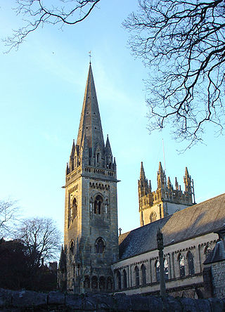
Llandaff is a district, community and coterminous electoral ward in the north of Cardiff, capital of Wales. It was incorporated into the city in 1922. It is the seat of the Bishop of Llandaff, whose diocese within the Church in Wales covers the most populous area of Wales.

<span class="mw-page-title-main">Llanishen</span> District and community in Cardiff, Wales

Llanishen is a district and community in the north of Cardiff, Wales. Its population as of the 2011 census was 17,417.

<span class="mw-page-title-main">Gabalfa</span> District and community of Cardiff, Wales

Gabalfa is a district and community in the north of the city of Cardiff, capital of Wales. It is characterised by a four-lane flyover road at the Gabalfa Interchange, where the A48 road meets the A470 road which leads from Cardiff to northern Wales, and the A469 road.

<span class="mw-page-title-main">Whitchurch, Cardiff</span> Suburb and community in Cardiff, Wales

Whitchurch is a suburb and community in the north of Cardiff, capital of Wales. It is approximately 3 miles north of the centre of the city on the A470 road and A4054 road. It falls within the Whitchurch & Tongwynlais ward. The population of the community in 2011 was 14,267.

<span class="mw-page-title-main">Cardiff West (UK Parliament constituency)</span> Parliamentary constituency in the United Kingdom, 1950 onwards

Cardiff West is a constituency represented in the House of Commons of the UK Parliament since 2001 by Kevin Brennan of the Labour Party.

<span class="mw-page-title-main">Riverside, Cardiff</span> District and community in Cardiff, Wales

Riverside is an inner-city area and community of Cardiff, Wales, next to the River Taff. Riverside is also the name of the electoral ward, which includes the district of Pontcanna, to the north. The population of the community in 2011 was 13,771. Pontcanna was removed from the community in 2016.

<span class="mw-page-title-main">Canton, Cardiff</span> District and community in Cardiff, Wales

Canton is an inner-city district and community in the west of Cardiff, capital of Wales, lying 2 miles (3.2 km) west of the city's civic centre. It is located adjacent to Pontcanna. Canton is one of the most ethnically diverse of Cardiff's suburbs, with a significant Pakistani and Indian population. The total population of Canton increased to 14,304 at the 2011 census. It is also the most Welsh-speaking district of central Cardiff, with 19.1% of the population speaking Welsh.

<span class="mw-page-title-main">Pontprennau</span> Community in Cardiff, Wales

Pontprennau is a ward and community in the north of the city of Cardiff, Wales, lying north of Pentwyn and Cyncoed, between the village of Old St Mellons and the farmlands east of Lisvane. The community had a population of 7,353 in 2011.

<span class="mw-page-title-main">Marshfield, Newport</span> Human settlement in Wales

Marshfield is a village and community of Newport, Wales. It sits approximately 5 miles southwest of Newport, and 7 miles northeast of Cardiff. The area is governed by Newport City Council. The community includes Castleton. Its population in 2011 was 3,054.

<span class="mw-page-title-main">Michaelston-y-Fedw</span> Village and community in Newport, Wales

Michaelston-y-Fedw is a small rural village and community to the west of the city of Newport, Wales, on the borders of Cardiff city and Caerphilly county boroughs. The population in 2011 was 296.

Transport in Cardiff, capital and most populous city in Wales involves road, rail, bus, water and air. It is a major city of the United Kingdom and a centre of employment, government, retail, business, culture, media, sport and higher education.

<span class="mw-page-title-main">Cycling in Cardiff</span> Transport by bicycle in Cardiff, Wales

Cycling in Cardiff, capital of Wales, is facilitated by its easy gradients and large parks. In the mid-2000s between 2.7% and 4.3% of people commuted to work by cycling in the city. In 2017 12.4% of workers cycled to work at least 5 days a week. However, cyclists in the city are deterred from cycling by poor facilities and aggressive traffic, according to research by Cardiff University.

The Cardiff & District League is a football league covering the city of Cardiff and surrounding areas in South Wales. The leagues are at the seventh to tenth levels of the Welsh football league system.

References

  1. "Adamsdown Parish". Nomis. Office for National Statistics. Retrieved 14 June 2024.
  2. "Butetown Parish". Nomis. Office for National Statistics. Retrieved 14 June 2024.
  3. "Caerau Parish". Nomis. Office for National Statistics. Retrieved 14 June 2024.
  4. "Canton Parish". Nomis. Office for National Statistics. Retrieved 14 June 2024.
  5. "Castle Parish". Nomis. Office for National Statistics. Retrieved 14 June 2024.
  6. "Cathays Parish". Nomis. Office for National Statistics. Retrieved 14 June 2024.
  7. "Cyncoed Parish". Nomis. Office for National Statistics. Retrieved 14 June 2024.
  8. "Ely Parish". Nomis. Office for National Statistics. Retrieved 14 June 2024.
  9. "Fairwater Parish". Nomis. Office for National Statistics. Retrieved 14 June 2024.
  10. "Gabalfa Parish". Nomis. Office for National Statistics. Retrieved 14 June 2024.
  11. "Grangetown Parish". Nomis. Office for National Statistics. Retrieved 14 June 2024.
  12. "Heath Parish". Nomis. Office for National Statistics. Retrieved 14 June 2024.
  13. "Lisvane Parish". Nomis. Office for National Statistics. Retrieved 14 June 2024.
  14. "Llandaff Parish". Nomis. Office for National Statistics. Retrieved 14 June 2024.
  15. "Llandaff North Parish". Nomis. Office for National Statistics. Retrieved 14 June 2024.
  16. 1 2 3 4 "The City and County of Cardiff (Communities) Order 2016". Legislation.gov.uk. Retrieved 14 June 2024.
  17. "Llanishen Parish". Nomis. Office for National Statistics. Retrieved 14 June 2024.
  18. "Llanrumney Parish". Nomis. Office for National Statistics. Retrieved 14 June 2024.
  19. "Old St. Mellons Parish". Nomis. Office for National Statistics. Retrieved 14 June 2024.
  20. "Pentwyn Parish". Nomis. Office for National Statistics. Retrieved 14 June 2024.
  21. "Pentwyn Parish". Nomis. Office for National Statistics. Retrieved 14 June 2024.
  22. "Penylan Parish". Nomis. Office for National Statistics. Retrieved 14 June 2024.
  23. "Pontprennau Parish". Nomis. Office for National Statistics. Retrieved 14 June 2024.
  24. "Radyr and Morganstown Parish". Nomis. Office for National Statistics. Retrieved 14 June 2024.
  25. "Rhiwbina Parish". Nomis. Office for National Statistics. Retrieved 14 June 2024.
  26. "Riverside Parish". Nomis. Office for National Statistics. Retrieved 14 June 2024.
  27. "Roath Parish". Nomis. Office for National Statistics. Retrieved 14 June 2024.
  28. "Rumney Parish". Nomis. Office for National Statistics. Retrieved 14 June 2024.
  29. "Splott Parish". Nomis. Office for National Statistics. Retrieved 14 June 2024.
  30. "St. Fagans Parish". Nomis. Office for National Statistics. Retrieved 14 June 2024.
  31. "Tongwynlais Parish". Nomis. Office for National Statistics. Retrieved 14 June 2024.
  32. "Trowbridge Parish". Nomis. Office for National Statistics. Retrieved 14 June 2024.
  33. "Whitchurch Parish". Nomis. Office for National Statistics. Retrieved 14 June 2024.