County Route76 is Town Line Road along the Islip–Smithtown township line. Until 1968, it was also part of Veterans Memorial Highway from Jericho Turnpike in Commack to Nesconset Highway in Hauppauge. The road shares a short concurrency with NY111 in Hauppauge. An eastern extension to CR16 was proposed at one time. The official Suffolk County Department of Public Works listing of county roads still includes this formerly proposed extension.[2]
County Route77 is the north-south road along the west side of Lake Montauk. It begins at an at-grade interchange of Montauk Point State Parkway as West Lake Drive where it intersects two streets that lead to the east side of Montauk Downs State Park, until it reaches CR70. From here the road runs much closer to Lake Montauk, then intersects with other roads such as Star Island Road to the right, and then East Flamingo Road (former CR95) to the left.
Before the road reaches the Block Island Sound, it intersects with the northern terminus of CR49. The road then takes a sharp right turn along the sound then loops around in the opposite direction and passes by the ferry port to Block Island, before returning to the intersection with CR49.
County Route78 is Church Street in the southeastern part of the town of Islip, from NY27 to Division Avenue in Patchogue. Originally, it was also Veterans Memorial Highway from Nesconset to Sunrise highways until it was extended westward towards Jericho Turnpike in Commack in 1968, replacing part of CR76. The southeast end of Veterans Memorial Highway bisected Church Street at Sunrise Highway, but only the part of Church Street on the south side of Sunrise Highway was a county road. The north side has never been anything else but a road maintained by the town of Islip. In 1972, Veterans Highway was acquired by the New York State Department of Transportation and designated NY454, but Church Street remained CR78.
County Route79 is a north-south two-lane road known as the Bridgehampton–Sag Harbor Turnpike.
History
Known in pre-colonial times as the "Cart Path to Great Meadows," it was replaced by the Bull Head Turnpike Company as a private toll road called the "Sag Harbor and Bull's Head Turnpike." Construction began in 1834 and the turnpike opened on March 29, 1837. The toll company shut down in 1905, and the toll houses were torn down in 1909.[6] The road was acquired by Suffolk County on November10, 1948.
County Route80 is the county route designation used for Montauk Highway (also labeled as Main Street, East Main Street and West Main Street) between East Patchogue and Shinnecock Hills.
Two Truck routes of County Route 80 exist in two locations. The first is in Moriches on Old Neck Road and Wilcox Avenue leading trucks around a low bridge beneath the Long Island Rail RoadMontauk Branch. The second includes North Bay Avenue in Eastport, New York, which leads truck drivers from another low bridge for the same line within the community, then turns right overlapping Old Country Road into Speonk, where it turns south on North Phillips Avenue and ends at Montauk Highway just south of the Speonk (LIRR station). The latter of these was originally designated as New York State Route 27 Truck, when New York State Route 27 was part of Montauk Highway between Exits 61 and 65 on Sunrise Highway.[7]
County Route81 is the shortest county road in Suffolk County. Known as Wharf Street, the road consists entirely of a 0.15-mile (0.24km) segment of the former Sag Harbor Branch of the Long Island Rail Road. It runs from an intersection with NY114 (Bay Street) to the end of the pier on Gardiners Bay. The Sag Harbor Branch was abandoned in 1940, and the road was established in 1949. It is not signed.
County Route82 is the designation for Higbie Lane from its starting point to Udall's Road, and for most of Udall's Road. It was named for the Richard Udall family who had an estate on South Country Road (now Montauk Highway). Higbie Lane starts as a two lane divided highway with a U-turn at NY27A (Montauk Highway), between the historic La Grange Inn and the West Islip Public Library, and instantly becomes a two-lane undivided highway with a center-left-turn lane. Heading north, CR82 intersect CR50, immediately followed by an at-grade crossing of the Long Island Rail RoadMontauk Branch near the Babylon Yard for the Babylon station, and then serves the west end of West Islip Boulevard, which runs along the north side of the tracks and becomes Orinoco Drive.
The route shifts to the northeast at a former wye onto Udall's Road, and Higbie Lane becomes a town of Islip maintained road. As Udall's Road, CR82 passes through another semi-residential area and then runs underneath the underpass of NY27 between exits 40 and 41. The next moderate intersection is with Hunter Avenue and Muncey Road. Together these roads span from CR34 to CR57 between Sunrise Highway and the Southern State Parkway. CR82 runs over the Southern State Parkway, but has no access to the parkway. The route finally ends at CR57, however while CR82 ends there, Udall's Road continues as a town of Islip road towards Howell's Road, which leads to Corbin Avenue and eventually to the Deer Park station.
County Route84 was a road that looped around northern Mattituck. This road included a bridge over Mattituck Creek that no longer exists. It began as Cox Neck Road on Sound Avenue, just west of the western terminus of what is today CR48 (Middle Road). It had only one street even remotely resembling a major intersection, Bergen Avenue. The road takes a sharp right turn and heads east where it used to cross over Mattituck Creek. On the east side of Mattituck Creek, the road was Mill Neck Road. As Mill Neck Road became Oregon Avenue in Oregon, CR84 turned south on Mill Road, where it crossed former CR27A then CR48 and headed back to NY25 near East Mattituck.
County Route86 runs from NY25 and Dix Hills Road as Broadway–Greenlawn and Centerport Road into Little Neck Road in Centerport.
Route description
CR86 begins at the intersection of NY25 and Dix Hills Road and at first runs northeast to southwest and immediately curves to a more northerly direction before the intersection of CR35. Just northeast of Lekamb Avenue, the road straightens out, briefly moving direct north. This change is short-lived as it heads back northeast at Lantern Street. After passing two T-intersections connecting CR86 to separate parts of Delamere Street, the road passes along the west side of a former apple grove that is now part of the Manor Plains Nature Park, a preserved land that is bisected by an L-shaped residential street which ends at Manor Road, a road which runs parallel to CR86. Residences do turn up again on the east side north of the intersection with Leigh Street on the west side. Parkland turns up again on the same side just south of the opposite side of the intersection with Depew Street, only to end again at a local dog kennel. What passes for a major intersection at this point is Little Plains Road, which is also part of New York State Bicycle Route 25A.
The heart of Greenlawn is reached at the intersection of CR9, the northwest corner of which contains Greenlawn Park, a local baseball field that runs along. The park is located along the west side of Broadway, east side of Cuba Hill Road, and south side of CR11 (Pulaski Road), which it intersects almost instantly. Further into town, CR86 passes an at-grade railroad crossing of the Port Jefferson Branch of the Long Island Rail Road close to Greenlawn Railroad Station. After passing the Harborfields Public Library, the road becomes much more residential. It curves to the left as it moves down the hills approaching the north shore, then makes a sharp curve to the northeast before the intersection with NY25A at the Suydam Homestead.
History
The road was once planned to be replaced by a four-lane divided highway known as CR107, which would've extended it down towards Belmont Lake State Park and West Babylon.
County Route87 is two-lane Edgewood Ave, which may have been part of NY25A. The road runs southwest to northeast north of the Port Jefferson Branch of the Long Island Rail Road, and is inventoried as a west-to-east road.
Route description
The road begins at the NY25–NY25A overlap in western Smithtown, at the north end of Brooksite Drive. Besides running north of the LIRR Port Jefferson Line, it also runs south of the Nissequogue River until it reaches Nissequogue River Road. Prior to this point, the road curves at a more easterly direction before the intersection of Landing Avenue. After passing by some surviving farmland as well as a middle school, the road enters the southernmost portion of the village of Head of the Harbor where it intersects Fifty Acre Road before ending at NY25A in St. James.
County Route88 is a two-lane highway known as Speonk–Riverhead Road, however the road doesn't go as far north as Riverhead as it originally did. The county describes the distance as being "3.8+ miles." The road terminates at the northeast corner of the Eastern Campus of Suffolk County Community College.
Most of the road continues through a section of the Long Island Central Pine Barrens, which feature the indigenous dwarf pine. This area fell victim to a widespread wildfire that burned a significant portion of the core of the Pine Barrens in 1995. Halfway along its existence, the road serves as an overpass for NY27, but does not have an interchange with it . After the road runs along the SCC Eastern Campus, CR88 ends at CR51 (East Moriches–Riverhead Road) in Northampton. The former section that actually got close to Riverhead is now only a dirt trail whose name only exists on paper.
County Route89, better known as Dune Road, spans the Southampton segment of Fire Island from the east side of Cupsogue Beach County Park at Moriches Inlet to the Shinnecock Inlet. It begins east of Moriches Inlet at Cupsogue Beach County Park, and crosses the Brookhaven–Southampton town line in West Hampton Dunes, which is almost entirely line with residential beach houses and the occasional private roads, with the exception of Pike's Beach town Park. Even after leaving the village, CR89 continues to maintain these characteristics, but occasionally features random beach clubs, recreational areas, and another town of Westhampton Beach named Lashley Beach
Moriches Bay ends on the north side of the street, and flows into Moneybogue Bay, which runs under the Jessup Lane Bridge in Westhampton Beach across from the Swordfish Beach Club. This is the first connection to the rest of Long Island. In between the segment along Moneybogue Bay, the residential beach houses continue to line the road, but more of them are surrounded by shrubs and small trees.
The bay flows into the much narrower Quantuck Creek, which runs under Beach Lane Bridge which is also in Westhampton Beach across from Rogers Beach. The pattern of beach houses blocked by greenery continues, but primarily along the Atlantic Ocean side of the road. When Quantuck Creek flows into Quantuck Bay, the houses are more abundant. Here the road also passes by the Quantuck Beach Club, which despite being located on the south side of the road, has a parking lot on the north side.
The road enters the village of Quogue just before the intersection of Water's Edge Road. The next intersection is Watersedge Drive, which ends where Quantuck Bay flows into the Quogue Canal. Within this area, CR89 passes the Surf Beach Club of Quogue, and then encounters its only major intersection, a wye intersection at the Post Lane Bridge which crosses the canal is the only access to the rest of Long Island in Quogue. Shortly after the bridge, the road passes the Quogue Beach Club.
While the south side of the road continues the pattern of private beach houses, most of the land on the north side of the road is undeveloped marshland, especially as Quogue Canal opens up into Shinnecock Bay. This pattern continues east of the village line. East of Dockers Waterside Restaurant, the north side of the road contains marshland that is so low, that satellite views make it appear as if the road runs along the bay itself.
At the intersection of Dolphin Lane, the northern portion of which terminates just out of reach of Sedge Island, CR89 serves as the terminus of another unpaved and unnamed road that would provide easier access to that island. This is soon overshadowed by a clister of residential streets on the south side, known as A Road, Road C, and Road D. A few Road B's can be found within that cluster, but none intersect with Dune Road. Northside marshland becomes more solid on another unnamed dirt road a block west of Triton Lane. East of here, the Shinnecock Bay resumes its domination of the north side of the road, with only a brief interruption of land. However, sparse north side residences begin turning up again across the street from the Hampton Ocean Resort, and soon after intersecting Mermaid Lane, Neptune Beach Club.
Further east along the bay the road enters Shinnecock Inlet County Park. The few intersections in this area are K Road and later Road K. The next intersection, however is for the Ponquogue Bridge in Ponquogue, which provides the last access point to the rest of Long Island. Parallel to this is an intersection with Beach Road, which leads to the former Ponquogue Bridge, now serving as a fishing pier. Both the former and current bridges are across from Ponquogue Beach. One more intersection with Road I can be found east of there before the road prepares to conclude near a series of restaurants and marinas on the north side. The last intersection is Road H, which is a dead end street at both ends, and the road ends at Shinnecock Inlet at a parking lot along the inlet with a light tower on the south end.
County Route90 is a pair of unsigned county roads (Furrows Road and Peconic Avenue) that were planned as a Central Suffolk Highway, the second part of a proposed reconnection of the two segments of NY24.
History
Suffolk County Department of Public Works added CR90 to the system on October 10, 1966, and officially describes the road as follows;
Beginning at C.R. 93, Lakeland Avenue–Ocean Avenue in the town of Islip, about 600 feet south of the Long Island Railroad(sic); thence easterly in general parallel to the Long Island Railroad to the vicinity of Knickerbocker Avenue; thence to Furrows Road in the vicinity of Lincoln Avenue; thence easterly along or in the vicinity of Barrett's Avenue to C.R. 83, Patchogue–Mt. Sinai Road(sic) at or in the vicinity of Peconic Avenue to C.R. 16, Horseblock Road(sic), a distance of 4.3 miles in the town of Islip, and 4.2 miles in the town of Brookhaven, a total distance of 8.5 miles.[2]
Reality has proven a much more ambitious proposal for CR90. From the interchange with CR97 (Nicolls Road) to Waverly Avenue (unsigned CR61), the right-of-way for separate westbound lanes has existed since the 1970s. Beyond Horse Block Road, the unbuilt ROW for the Central Suffolk Highway can be found beneath the CR101 bridge over the LIRR Main Line.[14] Road maps published between the 1960s and 1980s show a proposed road labeled CR90 between Moriches–Middle Island Road at North Street and CR111 at Hot Water Street,[15] the very location where other maps indicate that the proposed western extension of CR105 was intended to terminate.[16]
CR90 was neither built according to its official description, nor to its ultimate proposal. The only segments that originally existed when the route was designated are Furrows Road between Lincoln Avenue and Waverly Avenue, and Peconic Avenue between CR83 and CR16. Barrett's Avenue is a town of Brookhaven residential dead end street extending east of Waverly Avenue, however it does provide a connection to CR83 via Old Fish Road, a segment of the former Fish Thicket Road which is a local road dating back to the American Revolution.
Segments that could've been part of the proposed CR90 include a four-lane dead end highway near the Suffolk County Police Department headquarters on CR21 in Yaphank built during the 1970s, and a segment of Railroad Avenue South between CR29 and Knickerbocker Avenue built during the 1980s as part of the major reconstruction of Ronkonkoma Railroad Station.[17]
County Route91 was reserved for the formerly proposed Manorville Branch Road which was to be built on the aptly named former Manorville Branch of the Long Island Rail Road. The proposal was cancelled in 1986.
County Route92 is Oakwood Road, the most westerly county road in Huntington township. It begins at NY25 (Jericho Turnpike) in West Hills, east of the intersection of Sweet Hollow Road, which runs through West Hills County Park before heading south to CR3. Though described as a two-lane road, it often provides a center-left turn lane that isn't necessarily continuous. Motorists are left with no doubt that they're in Huntington Manor when CR92 runs along the east side of Oakwood Park, near the southwest corner of the grade crossing with the Port Jefferson Branch of the Long Island Rail Road, and immediately intersects 11th Street, which serves as the southern end of the multiplex with New York State Bicycle Route 25A. As the area returns to becoming more residential, the barely noticeable multiplex ends at the intersection of CR11 (Pulaski Road).
North of CR11, CR92 runs between NY108 and NY110. A former segment of the road can be found on the east side between Jefferson Elementary School and north of Waywood Place. This segment is now a residential frontage road. After passing this segment the road curves to the northeast as it passes later a high school athletic field, and begins to move closer to NY110. It begins to descend along the hills of the North Shore of Long Island as it curves back north again between Holdsworth Drive and Semon Road. Upon running back to its more northerly destination, the road first passing by a Suffolk County Department of Public Works building and the Huntington Highway Department, and then along the Western edge of Huntington Rural Cemetery. In the opposite direction, a southbound hill-climbing lane exists between Finch Place and the previously mentioned high school athletic field.
As the road approaches High Street, Oakwood Road becomes Green Street, but CR92 uses the turning ramp onto High Street to turn east, and serves as the beginning of the end for the county road. CR92 ends at the David Conklin Farmhouse on the southwest corner of NY110 three blocks south of the intersection of NY25A. High Street turns into Fairview Street which continues east into Nassau Road.
County Route93 is a major county road within central Suffolk County, primarily in the eastern part of the town of Islip and partially in the southeastern section of the town of Smithtown. It runs north and south from NY27 in Bohemia near Sayville to CR16 in Lake Ronkonkoma. Names of the route include Lakeland Avenue, Ocean Avenue, and Rosevale Avenue.[19]
Route description
Lakeland Avenue actually begins at CR85 in Sayville as Railroad Avenue and leaves downtown Sayville at a northwesterly direction. Among the locations within this section are Sayville's train station, Johnson Avenue, Tariff Street, and the abandoned Island Hills Golf and Country Club. Only when Lakeland Avenue encounters the interchange with NY27 at exit49 does the road acquire its designation as CR93. This segment was the first to be widened from two to four lanes. Between the intersections of NY454 and Smithtown Avenue (unsigned CR29), one can find the end of runway #6 for the Long Island MacArthur Airport. At the intersection with Pond Road and Locust Avenue, CR93 enters the Pond Road Business District, an industrialized section of Pond Road. Pond Road once stretched from Lake Ronkonkoma to Oakdale, near what is today the Oakdale Merge at Sunrise and Montauk highways.
Lakeland Avenue terminates at the at-grade interchange with Ocean Avenue, and CR93 becomes Ocean Avenue north of there. South of the interchange, Ocean Avenue once went as far south as Montauk Highway, then was rerouted toward Locust Avenue by developers and in recent years was terminated at the westbound service road of Sunrise Highway. North of the interchange the last section to be widened was between Peconic Street and Johnson Avenue due partially to the crossing of the Ronkonkoma Branch of the Long Island Rail Road. The southwest corner of Ocean and Johnson avenues was the original site of Lakeland's LIRR station.[20] North of there, CR93 crosses I-495 at exit59, and then the Long Island Power Authority power line right of way. At the intersection of Woodlawn Avenue and Ontario Street, Ocean Avenue curves to the right and starts to go downhill as it approaches Lake Ronkonkoma.
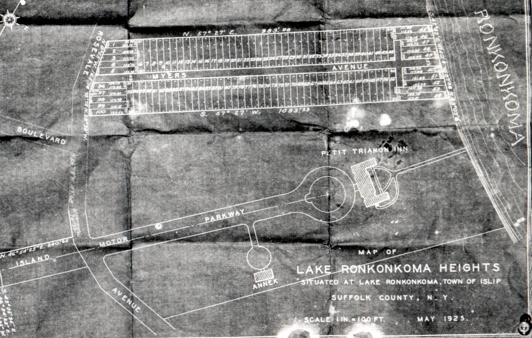
Ocean Avenue terminates at the at-grade interchange with Rosevale Avenue, and then CR93 head northwest along Rosevale Avenue, around the western edge of Lake Ronkonkoma. Rosevale Avenue extends east as a town of Islip street, where it becomes Church Street as it crosses the Islip–Brookhaven town line. After passing by a town of Islip Beach for the lake, CR93 dips towards the Vanderbilt Motor Parkway. The eastern terminus of Vanderbilt Motor Parkway was truncated at CR93. Originally intended to be extended towards the Hamptons, possibly using Rosevale Avenue as a segment, Vanderbilt Motor Parkway was stopped at the former Petit Trianon Hotel, which Rosevale originally ran through the western edge of,[21] and was burned down in 1968. After the Motor Parkway intersection, and the nearby intersection with Central Islip Boulevard, CR93 climbs back up another hill as it approaches Richmond Boulevard, which leads to Old Nichol's Road. Just as the road crosses the Islip–Smithtown town line, it finally terminates at CR16 (Smithtown Boulevard) in Lake Ronkonkoma. Work was done recently to eliminate the two separate intersections at the terminus of CR93; formerly Gibbs Pond Road intersected CR16 just east of CR93, but these intersections have been made into one by using the property on which an abandoned building once stood.
County Route94A is Center Drive Spur, a four-lane highway that crosses the Peconic River between NY24 and CR94 and West Main Street (NY25) and Court Street.
County Route95 is mainly Little East Neck Road north of NY109 in West Babylon. Little East Neck Road runs northwest to southeast and begins as part of the west-to-east NY109. However, when NY109 moves in a more westerly direction onto the Babylon–Farmingdale Turnpike, the road becomes CR95. The first major intersection along this road is the northeast to southwest unmarked CR107 (Belmont Avenue). Four blocks later both roads go over NY27, and share exit38.
Although it crosses over Southern State Parkway, it provides no access. However it marks the west end of a section of the parkway that gets a widened pine tree-lined median before it approaches Belmont Lake State Park. The road runs through another residential area before it approaches the eastern terminus of Edison Avenue and Hilltop Avenue, where it approaches a green strip leading southeast towards the Southern State Parkway as it intersects County Road 2 (Straight Path). Further north, the road runs along the eastern end of Wellwood Cemetery, and some private land abutting Beth Moses Cemetery and Colonial Springs Golf Course, both of which are across from Wyandanch Memorial High School. Two blocks north of the high school is an intersection with Long Island Avenue, on the south side of the at-grade crossing of the Ronkonkoma Branch of the Long Island Rail Road and then runs through Pinelawn Cemetery. On the east side of the road Pinelawn Cemetery ends at Colonial Springs Park, and on the west side it ends less than a block north at Long Island National Cemetery, which dominates the entire west side of the road until it ends.
Little East Neck Road terminates at Colonial Springs Road, although at one time it extended much further north. Due to the terminus, of Little East Neck Road, CR95 moves to the northwest onto Colonial Springs Road, and continues to serve as the eastern edge of LI National Cemetery. CR95 terminates at the intersection of CR3 (Pinelawn Road) in Melville, and turns southwest into CR5. At one time, however it turned into Bayliss Road and continued to the northwest towards Walt Whitman Road (former NY110).
County Route96 is Great East Neck Road just south of the southern terminus of CR95. The designation was established on February2, 1958 and extended along Bergen Avenue on December8, 1970, where it dead ends at the Bergen County Golf Course on South Oyster Bay.
County Route97 is a major county road which is a partially limited-access road that runs north and south from CR85 (Montauk Highway) on the border of Bayport and Blue Point to NY25A in Stony Brook.
County Route98 is a road running east and west from CR80 in Moriches to CR80 in East Moriches. The road goes under two names; Frowein Road and the Moriches Bypass.
History
Frowein Road has always been only two-lanes wide, but three years after being designated a county road in 1958, it was given additional right-of-ways for widening, as well as an at-grade interchange on the west end.[22] Plans for upgrading the road as a bypass go as far back as the 1930s.[23] The at-grade interchange also includes access to Moriches–Middle Island Road, a historic Long Island road that leads to CR21 (Rocky Point–Yaphank Road). In addition, Suffolk County had planned to realign CR 25 from this interchange north through exit69 on the Long Island Expressway. The proposed widening of the Moriches Bypass was also to include a section of Montauk Highway from the east end of Frowein Road into downtown Eastport. Due to fiscal concerns, and a general atmosphere of opposition to road improvements, this proposal was never implemented.
Just as Montauk Highway was realigned along the north side of the Montauk Branch of the Long Island Rail Road between East Patchogue and Brookhaven to divert through traffic away from Historic Bellport, Frowein Road was transformed into the Moriches Bypass, partially to divert truck traffic and through traffic away from historic sections of Moriches, Center Moriches, and East Moriches, as well as the low railroad bridges in Moriches and East Moriches. Since the road runs along the north side of the LIRR tracks, it served as a more convenient route to Center Moriches Station until the Long Island Rail Road closed that station on March 16, 1998. East Moriches Station was also closer to Frowein Road, but that station was closed by the LIRR two years before Suffolk County upgraded the road.
Truck Route 27A
From 1960 to 1972, Frowein Road was designated both as CR98 and as New York State Truck Route 27A. Since Montauk Highway was designated New York State Route 27A as far as Eastport at the time, the road was considered an important detour for high trucks that would otherwise collide with the low railroad bridges over the then existing NY 27A in Moriches and East Moriches, New York.[24] When the New York State Department of Transportation began to phase New York State Route 27A out east of Oakdale, New York, the designation as CR98 became more prominent.[25] Today, Truck Detour CR80's exist closer to those bridges. The truck route around the bridge in Moriches is at Old Neck Road and Wilcox Avenue, and the truck route around the bridge in East Moriches is as Pine Street and Frowein Road.
County Route99 is a major county road in the towns of Islip and southern Brookhaven. It runs east and west from CR19 in Holtsville in the far-eastern town of Islip to CR16 near Yaphank and Brookhaven hamlet, all in the southern town of Brookhaven.
Route description
The western end is a four-lane divided highway that contains a partial interchange with Waverly Avenue, and a full interchange with Buckley Road. It also includes an underpass for a driveway to the Holtsville Branch of the Internal Revenue Service near the Waverly Avenue interchange. This status is reduced northwest of Cannan Lake. Much of the road is a four-lane undivided highway with a center-left-turn lane used for residents and local intersections, except at the intersections of CR83, Old Medford Avenue, and NY112, where small concrete dividers run along the median of the road. The center-left-turn lane was previously a painted divider. From west of Old Medford Avenue to west of CR101 (Patchogue–Yaphank Road), CR99 borders Medford to the north and North Patchogue and East Patchogue to the south. Radio station WNYG (1580 AM) is located at the northeast corner of CR99 and Pennsylvania Avenue.
After the intersection of Hospital Road, a street which leads to Brookhaven Memorial Hospital, CR99 runs along the south side of a section of Medford known as The Pines, which includes a local recreational area known as Twelve Pines Park on the northeast corner of Sipp Avenue, and northwest of Pine Gate. The eastern end is also divided with a concrete barrier beginning west of CR101, and a wider divider east of Station Road, where it resumes its status as a major highway. One last intersection with a housing development that replaced a former dirt road leading to the village of Bellport can be found before CR99 approaches the Brookhaven town landfill and curves left before terminating at an incomplete at-grade interchange with CR16 (Horse Block Road) in Brookhaven.
History
Stub for a never-built west-to-northbound ramp that runs parallel to the existing west-to-northbound CR 99 ramp at CR 19.
Woodside Avenue was officially designated as CR99 on October27, 1970, as a former Brookhaven town road spanning from Canaan Lake to Station Road in North Bellport It was widened to four lanes and extended during the mid-1970s. West Woodside Avenue which runs west of the north end of Canaan Lake, was a former section of Woodside Avenue.
At the west end of CR99, there were originally stubs built for a new ramp and a possible extension beyond CR19, to either CR97 (Nicolls Road) or NY454 (Veterans Memorial Highway). East of CR16 (Horse Block Road), there were plans to upgrade the interchange into a limited-access one, and extend the road into CR21 (Yaphank Avenue). The Suffolk County Department of Public Works' official list of County Roads still included the eastern extension as part of the highway in 1986, but the construction of these extensions were never implemented.
County Route100 runs east and west from CR13 in Brentwood to NY454 in the village of Islandia. The route runs along the north side of the Ronkonkoma Branch of the Long Island Rail Road, and is four lanes wide from CR13 to Brentwood Station, and again from CR17 to NY454. In between, the rest of the road remains two lanes, but has been anticipating the possibility of being widened to four lanes, since the two ends of the road were widened during the 1970s.
The original plan for CR100 was to extend the road west of CR13 along the main line of the Long Island Rail Road terminating it at NY24 by way of the formerly proposed Republic Bypass.[26]
Suffolk County is the easternmost county in the U.S. state of New York, constituting the eastern two-thirds of Long Island. It is bordered to its west by Nassau County, to its east by Gardiners Bay and the open Atlantic Ocean, to its north by Long Island Sound, and to its south by the Atlantic Ocean.
Islip is a town in Suffolk County, New York, United States, on the South Shore of Long Island. The population was 335,543 at the 2010 census, making it the fourth most populous city or town in the New York metropolitan area.
Brookhaven, formally the Town of Brookhaven, is a large suburban town in Suffolk County, Long Island, New York. With a population of 488,497 as of 2022, it is the second most populous town in the United States and in New York and the third most populous community in the state.
Montauk Highway is an east–west road extending for 95 miles (153 km) across the southern shore of Long Island in Suffolk County, New York, in the United States. It extends from the Nassau County line in Amityville, where it connects to Merrick Road, to Montauk Point State Park at the very eastern end of Long Island in Montauk. The highway is known by several designations along its routing, primarily New York State Route 27A (NY 27A) from the county line to Oakdale and NY 27 east of Southampton. The portion of Montauk Highway between Oakdale and Southampton is mostly county-maintained as County Route 80 and County Route 85.
New York State Route 25 (NY 25) is an east–west state highway in downstate New York in the United States. The route extends along the central parts and North Shore of Long Island for just over 105 miles (169 km) from east midtown Manhattan in New York City to the Cross Sound Ferry terminal at Orient Point on the end of Long Island's North Fork. NY 25 is carried from Manhattan to Queens by way of the double-decked Queensboro Bridge over the East River.
New York State Route 27 (NY 27) is a 120.58-mile (194.05 km) long state highway that runs east–west from Interstate 278 (I-278) in the New York City borough of Brooklyn to Montauk Point State Park on Long Island, New York. Its two most prominent components are Sunrise Highway and Montauk Highway, the latter of which includes the Montauk Point State Parkway. NY 27 acts as the primary east–west highway on southern Long Island east of the interchange with the Heckscher State Parkway in Islip Terrace. The entire route in Suffolk, Nassau, and Queens counties were designated by the New York State Senate as the POW/MIA Memorial Highway. The highway gives access to every town on the South Shore. NY 27 is the easternmost state route in the state of New York, as well as the longest highway on Long Island.
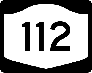
New York State Route 112 (NY 112) is a state highway located entirely within the town of Brookhaven in Suffolk County, New York, in the United States. It runs from an intersection with Montauk Highway in the village of Patchogue to a junction with NY 25A in Port Jefferson Station. It is known locally as Medford Avenue in Patchogue and Patchogue Road in Terryville and Port Jefferson Station. The official name for the road outside these areas is "Patchogue–Port Jefferson Road", though it is often signed simply as "Route 112".
New York State Route 24 (NY 24) is a 30.84-mile-long (49.63 km) east–west state highway on Long Island in the U.S. state of New York. The highway is split into two segments, with the longer and westernmost of the two extending 18.68 miles (30.06 km) from an interchange with Interstate 295 and NY 25 in the Queens Village section of the New York City borough of Queens to an intersection with NY 110 in East Farmingdale in the Suffolk County town of Babylon. The shorter eastern section, located in eastern Suffolk County, extends 12.16 miles (19.57 km) from an interchange with I-495 in Calverton to an intersection with County Route 80 (CR 80) in Hampton Bays.
New York State Route 111 (NY 111) is a state highway located in Suffolk County, New York, in the United States. It runs north–south for 9.42 miles (15.16 km) through the towns of Islip and Smithtown, connecting NY 27A in the town seat of Islip to the east end of the NY 25 and NY 25A concurrency in Smithtown's Village of the Branch. Most of the road is a two-lane highway, save for several short four-lane stretches in the vicinity of interchanges along the route. NY 111 was assigned as part of the 1930 renumbering of state highways in New York as an East Islip–Village of the Branch highway, using what is now County Route 17 (CR 17) south of Hauppauge. It was realigned to serve the hamlet of Islip in 1966.
New York State Route 27A (NY 27A) is a state highway between Massapequa in Nassau County and Oakdale in Suffolk County, on Long Island, New York, in the United States. Its two most prominent components are Merrick Road and Montauk Highway.
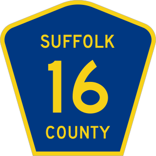
County Route 16 (CR 16) is a main thoroughfare through central Suffolk County, New York, in the United States. Its western terminus is at Middle Country Road in Village of the Branch, and its eastern terminus is at Montauk Highway (CR 80) in Brookhaven. The route carries five different names along its length: Terry Road, Smithtown Boulevard, Lake Shore Road, Portion Road, and Horseblock Road.
County Route 97 (CR 97) is a north–south expressway in Suffolk County, New York, in the United States. It runs from an intersection with CR 85 in Bayport just west of Blue Point on the south shore of Long Island to a junction with New York State Route 25A (NY 25A) in Stony Brook on the island's north shore. A 5-mile (8.0 km) section of the route from Holbrook to Farmingville is a freeway, while the remainder of the road is an expressway with at-grade intersections. CR 97 is known as Nicolls Road, named after 17th-century colonial Governor Richard Nicolls.
County Route 83 (CR 83) is a major north–south county road in Suffolk County, New York, in the United States. It runs from NY 27 exit 52A in North Patchogue to NY 25A in Mount Sinai. The road was to have to run further south along North Ocean Avenue and South Ocean Avenue through the village of Patchogue, but that proposal was canceled. CR 83 is known as North Ocean Avenue south of Granny Road in Medford and as Patchogue–Mount Sinai Road north of that point.
County Route 46 (CR 46) is a major county road in eastern Suffolk County, New York, in the United States. It runs south-to-north from CR 75 in Smith Point County Park to New York State Route 25A (NY 25A) near the border of Shoreham and Wading River. The road is known as the William Floyd Parkway along its entire length, and is named after William Floyd, a Long Island native and a signer of the United States Declaration of Independence. Despite its "parkway" designation within the State of New York, the road is open to commercial vehicles.
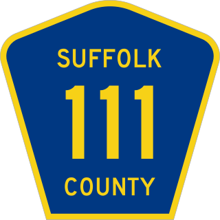
County Route 111 (CR 111) is a north–south county road in Suffolk County, New York, in the United States. It runs northwest and southeast from New York State Route 27 (NY 27) at exit 62 near Eastport to Interstate 495 (I-495) at exit 70 in Manorville. It serves as a connecting route between central Long Island and the Hamptons. The road is known as Captain Daniel Roe Highway, for Captain Daniel Roe (1740–1820) of Selden, who served in the French and Indian War and was a captain in the Revolutionary War. Within Manorville, the road is also known as Eastport Manor Road. It also appears on maps as Port Jefferson-Westhampton Road, for the communities in which the route was originally intended to have its north and south endpoints in.
↑ "Construction Work Commences on 'Moriches By-Pass'". The Patchogue Advance. April 6, 1961.
↑ "Proposed Revised Plan of Major Highways". Town of Brookhaven (Suffolk County). August 4, 1937.{{cite journal}}: Cite journal requires |journal= (help)
This page is based on this Wikipedia article Text is available under the CC BY-SA 4.0 license; additional terms may apply. Images, videos and audio are available under their respective licenses.


