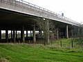
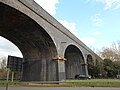
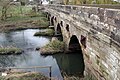
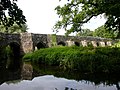
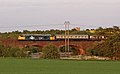
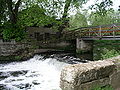
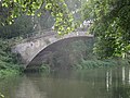
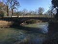
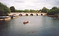
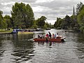
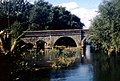
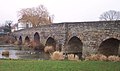
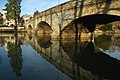
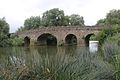
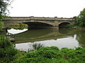
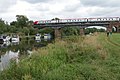
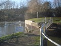
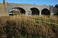
Crossing Date Coordinates Heritage Locality Notes Image Source of the River Avon n/a 52°23′51″N 0°59′19″W / 52.3975°N 0.9887°W / 52.3975; -0.9887 (The source of the River Avon ) n/a Naseby , Northamptonshire Included for completeness M1 motorway 1965-1968 52°23′43″N 1°10′23″W / 52.395144°N 1.172958°W / 52.395144; -1.172958 (M1 Avon Bridge ) n/a Lilbourne /Catthorpe (river forms county boundary between Northamptonshire & Leicestershire here) Elevated motorway over floodplain of infant river and disused railway Dow Bridge 1838 52°23′48″N 1°12′10″W / 52.396599°N 1.202795°W / 52.396599; -1.202795 (Dow Bridge ) II Newton Disused. Incorporates parts of a circa 1776 bridge which it replaced. Marks the tri-point of Northamptonshire, Leicestershire and Warwickshire. [ 2] [ 3] [ 4] Dow bridge (new) 1930s 52°23′48″N 1°12′11″W / 52.39655°N 1.20297°W / 52.39655; -1.20297 (Dow Bridge (new) ) Newton Replaced the earlier Dow Bridge. Carries the A5 . Midland Counties Railway Viaduct 1840 52°23′04″N 1°15′50″W / 52.384531°N 1.263976°W / 52.384531; -1.263976 (Midland Counties Railway Viaduct ) II Rugby Disused railway viaduct; now pedestrians only. [ 5] [ 6] Bretford Bridge 18th century 52°23′21″N 1°22′12″W / 52.389186°N 1.370108°W / 52.389186; -1.370108 (Bretford Bridge ) II Bretford , Brandon and Bretford Stone road bridge of 13th century origin, largely rebuilt to the original design in the 18th century. Carries the A428 road over one semi-circular and 4 pointed arches. [ 7] [ 8] Brandon Viaduct (or Avon Viaduct) 1838 52°22′53″N 1°23′59″W / 52.38126°N 1.39964°W / 52.38126; -1.39964 (Brandon Viaduct ) II Brandon and Bretford Carries the Birmingham Loop of the West Coast Main Line ; built as part of part of the London and Birmingham Railway . [ 9] Stare Bridge Late 15th century 52°20′24″N 1°31′04″W / 52.34000°N 1.51777°W / 52.34000; -1.51777 (Stare Bridge ) II* Stoneleigh 9 arches. [ 10] Chesford Bridge (A452) 52°19′33″N 1°33′25″W / 52.325969°N 1.556909°W / 52.325969; -1.556909 (Chesford Bridge ) Blackdown Vehicle and pedestrian. Stone, five arches. Hill Wootton Road 52°19′09″N 1°32′49″W / 52.319289°N 1.546806°W / 52.319289; -1.546806 (Hill Wootton Road bridge ) Blackdown Vehicle and pedestrian. Old Milverton rail viaduct 52°18′32″N 1°33′41″W / 52.308954°N 1.561267°W / 52.308954; -1.561267 (Old Milverton rail viaduct ) Old Milverton Multiple arch brick rail viaduct Saxon Mill 52°18′04″N 1°34′24″W / 52.301024°N 1.573214°W / 52.301024; -1.573214 (Saxon Mill weir and bridge ) II Leek Wootton and Guy's Cliffe Weir and foot bridge Sir Anthony Eden Way 2007 52°17′28″N 1°33′35″W / 52.291122°N 1.559741°W / 52.291122; -1.559741 (Sir Anthony Eden Way bridge ) Leamington Spa and Warwick Road bridge Portobello Bridge 1831 52°17′21″N 1°33′36″W / 52.289216°N 1.560064°W / 52.289216; -1.560064 (Portobello Bridge ) II Leamington Spa and Warwick Three span stone bridge. [ 11] Grand Union Canal 1800 52°17′11″N 1°33′38″W / 52.286378°N 1.560452°W / 52.286378; -1.560452 (Grand Union Canal aqueduct, Leamington Spa ) Leamington Spa Aqueduct Chiltern Main Line 1852 (original) 52°17′05″N 1°33′47″W / 52.284757°N 1.563156°W / 52.284757; -1.563156 (Chiltern Main Line viaduct, Warwick ) Warwick Metal railway viaduct Charter Bridge 1996 52°16′58″N 1°34′17″W / 52.282894°N 1.571323°W / 52.282894; -1.571323 (Charter Bridge, Warwick ) Warwick Metal pedestrian and cycle bridge Castle Bridge 1793 52°16′47″N 1°34′46″W / 52.279629°N 1.579537°W / 52.279629; -1.579537 (Castle Bridge ) II* Warwick Replaced Old Castle Bridge. [ 12] [ 13] Old Castle Bridge 1208 or before 52°16′45″N 1°35′00″W / 52.279214°N 1.583308°W / 52.279214; -1.583308 (Old Castle Bridge ) II* Warwick Destroyed 1795. Impassible ruins only remain. [ 14] [ 15] [Unnamed bridge] 52°16′45″N 1°35′00″W / 52.279214°N 1.583308°W / 52.279214; -1.583308 (Old Castle Bridge ) Warwick Footbridge only, wooden, on private land. Part of the Warwick Castle estate Leafield Bridge 1772 52°15′53″N 1°35′31″W / 52.26484°N 1.59195°W / 52.26484; -1.59195 (Leafield Bridge ) II Warwick A stone bridge designed by Robert Mylne. [ 16] M40 motorway 52°15′25″N 1°35′53″W / 52.2569°N 1.5980°W / 52.2569; -1.5980 (M40 ) A pair of adjacent bridges, one for each carriageway. Barford 18th century 52°14′47″N 1°36′33″W / 52.2463°N 1.6092°W / 52.2463; -1.6092 (Barford ) II Barford Five sandstone arches. [ 17] Barford Bypass 52°14′46″N 1°36′38″W / 52.2462°N 1.6105°W / 52.2462; -1.6105 (Barford Bypass ) Barford Hampton Lucy Bridge 1829 52°12′44″N 1°37′28″W / 52.2121°N 1.62442°W / 52.2121; -1.62442 (Hampton Lucy Bridge ) II Hampton Lucy Cast iron . [ 18] [Unnamed] 52°12′11″N 1°41′01″W / 52.20294°N 1.68349°W / 52.20294; -1.68349 (Unnamed bridge ) Avon Caravan Park, Tiddington Clopton Bridge 1484 (circa) 52°11′30″N 1°42′01″W / 52.19155°N 1.700311°W / 52.19155; -1.700311 (Clopton Bridge ) SM
Stratford-upon-Avon Replaced a timber bridge first mentioned in 1235. [ 19] Tramway Bridge 1823 52°11′28″N 1°42′05″W / 52.191049°N 1.701417°W / 52.191049; -1.701417 (Tramway Bridge ) II Stratford-upon-Avon Eight brick arches which carried a horse tramway, now pedestrian only. [ 20] Stratford-upon-Avon chain ferry 1937 52°11′21″N 1°42′20″W / 52.189035°N 1.705475°W / 52.189035; -1.705475 (Stratford-upon-Avon chain ferry ) Stratford-upon-Avon Manually operated chain ferry . [ 21] Lucy's Mill bridge 52°11′02″N 1°42′29″W / 52.18380°N 1.70811°W / 52.18380; -1.70811 (Lucy's Mill bridge ) Stratford-upon-Avon footbridge Seven Meadows Road bridge 52°11′01″N 1°42′30″W / 52.18368°N 1.70826°W / 52.18368; -1.70826 (Seven Meadows Road bridge ) Stratford-upon-Avon A4390 Stratford Greenway 52°10′40″N 1°43′36″W / 52.17767°N 1.72654°W / 52.17767; -1.72654 (Stratford Greenway ) Stratford-upon-Avon Former railway Binton Bridge 1783 (circa) 52°10′32″N 1°47′22″W / 52.17561°N 1.78955°W / 52.17561; -1.78955 (Binton Road ) II Welford-on-Avon Passes over an island in the river on seven arches of Blue Lias . [ 22] Bidford Bridge early 15th century 52°09′50″N 1°51′24″W / 52.16402°N 1.85666°W / 52.16402; -1.85666 (Bidford Bridge ) SM
Bidford-on-Avon , Warwickshire Eight arch bridge of limestone. [ 23] George Billington Lock footbridge 52°07′22″N 1°54′21″W / 52.12280°N 1.90570°W / 52.12280; -1.90570 (George Billington Lock footbridge ) Only crosses navigation arm Simon de Montford Bridge 52°06′21″N 1°55′45″W / 52.1059°N 1.9293°W / 52.1059; -1.9293 (Simon de Montford Bridge ) near Greenhill , Worcestershire Carries A46 . [ 24] Even Railway Bridge 52°05′50″N 1°56′09″W / 52.0972°N 1.9357°W / 52.0972; -1.9357 (Even Railway Bridge ) Evesham Cotswold Line (railway) Workman Bridge 1856 52°05′29″N 1°56′35″W / 52.091492°N 1.943074°W / 52.091492; -1.943074 (Workman Bridge ) II Evesham A stone bridge of three arches. [ 25] Abbey Bridge 52°05′11″N 1°57′07″W / 52.08636°N 1.95190°W / 52.08636; -1.95190 (Abbey Bridge ) Evesham Cotswold Line (2) 52°06′03″N 1°57′16″W / 52.10081°N 1.95451°W / 52.10081; -1.95451 (Cotswold Line (2) ) Evesham Railway Evesham Golf Course Railway Bridge 52°07′06″N 2°00′22″W / 52.11833°N 2.00606°W / 52.11833; -2.00606 (Evesham Golf Course Railway Bridge ) Fladbury Cotswold Line (railway) Jubilee Bridge 1935 52°06′31″N 2°00′03″W / 52.108647°N 2.000848°W / 52.108647; -2.000848 (Jubilee Bridge ) Fladbury Replaced an earlier bridge, named for the Golden Jubilee of Queen Victoria [Unnamed pipeline] 52°06′23″N 2°01′51″W / 52.10635°N 2.03073°W / 52.10635; -2.03073 (pipeline ) Fladbury No pedestrian access Pershore Old Bridge probably late C15 52°06′16″N 2°04′16″W / 52.104551°N 2.070998°W / 52.104551; -2.070998 (Pershore Old Bridge ) SM
Pershore Now pedestrian/ cycle only. Five span bridge of sandstone with a red brick parapet. [ 26] Pershore Bridge 52°06′15″N 2°04′17″W / 52.104200°N 2.071316°W / 52.104200; -2.071316 (Pershore Bridge ) Pershore Replaced Pershore Old Bridge Nafford Lock 52°04′30″N 2°05′19″W / 52.0751°N 2.0885°W / 52.0751; -2.0885 (Nafford Lock ) Chain of three bridges, via island; pedestrians only Eckington Bridge 1720 (circa) 52°04′45″N 2°06′54″W / 52.0793°N 2.1149°W / 52.0793; -2.1149 (Eckington Bridge ) II* Eckington , Worcestershire Carries the B4080 road. First bridge at the site was built in 1440, replacing an earlier ferry. [ 27] [ 28] [ 29] Defford Railway Bridge 52°04′50″N 2°07′19″W / 52.0805°N 2.1220°W / 52.0805; -2.1220 (Defford Railway Bridge ) Birmingham and Gloucester Railway [ 30] Strensham Lock 52°03′37″N 2°07′25″W / 52.06034°N 2.12369°W / 52.06034; -2.12369 (Strensham Lock ) Eckington , Worcestershire Chain of small bridges and islands M5 motorway 52°01′50″N 2°07′32″W / 52.03063°N 2.12547°W / 52.03063; -2.12547 (M5 ) A pair of parallel bridges, one for each carriageway. Tewkesbury Quay 51°59′56″N 2°09′17″W / 51.99887°N 2.15476°W / 51.99887; -2.15476 (Tewkesbury Quay ) Tewkesbury , Gloucestershire Tewkesbury and Malvern Railway bridge 51°59′56″N 2°09′17″W / 51.99888°N 2.15474°W / 51.99888; -2.15474 (Tewkesbury and Malvern Railway bridge ) Demolished and replaced with a footbridge King John's Bridge 1190 (circa); restructured 1824 51°59′52″N 2°09′24″W / 51.9978°N 2.1567°W / 51.9978; -2.1567 (King John's Bridge ) II* Tewkesbury Crosses the bifurcated Avon, twice, via an island, on five sandstone arches. Carries the A38 , Mythe Road. [ 31] Confluence with River Severn n/a 51°59′47″N 2°09′48″W / 51.9964°N 2.1634°W / 51.9964; -2.1634 (Confluence with River Severn ) n/a Tewkesbury Included for completeness