List of crossings of the River Esk, North Yorkshire

Last updated

Duck Bridge Ford near Danby Duck Bridge Ford near Danby - geograph.org.uk - 3807462.jpg
Duck Bridge Ford near Danby

This is a list of current bridges and other crossings of the River Esk and are listed from source downstream to the river's mouth. The River Esk rises near Westerdale and is the combination of several small streams known as "Esklets". [1] The river valley has been beset by serious flooding in 1828, 1880, and 1930. Several bridges were lost during the floods of 1930. Most of the railway bridges have numbers, rather than names according to the Engineer's Line Reference. [2]

Contents

The river has been crossed by many fords although most are now not in everyday use. Some of these fords are referred to as a "wath", which is from the Old Norse vað meaning ford. Examples of this are at Briggswath, Hellawath (in Glaisdale), and Bluewath Beck (in Egton). [3]

Source to Glaisdale

CrossingLocationTypeCo-ordinatesDate openedListingNotesRef
Osseker Crook Bridge (Foot) Westerdale Foot 54°26′20″N0°59′14″W / 54.4390°N 0.9871°W / 54.4390; -0.9871 (Osseker Crook Bridge) UnknownN/A
Upper Esk Road bridgeWesterdaleRoad 54°26′47″N0°58′47″W / 54.4464°N 0.9798°W / 54.4464; -0.9798 (Upper Esk Road bridge) UnknownN/AOpened to replace traffic having to use Hunter's Sty Bridge adjacent to the east [4]
Hunter's Sty BridgeWesterdale Packhorse 54°26′47″N0°58′46″W / 54.4465°N 0.9795°W / 54.4465; -0.9795 (Hunter's Sty Bridge) c.late 13th centuryScheduled monument [5]
Dibble Bridge Castleton Road 54°27′42″N0°57′32″W / 54.4618°N 0.9590°W / 54.4618; -0.9590 (Dibble Bridge) c.1720 II A bridge was mentioned at this location in 1301 and 1539, though the current bridge dates back to the early 18th century. [6] [7]
Bow BridgeCastletonRoad 54°27′59″N0°56′41″W / 54.4663°N 0.9446°W / 54.4663; -0.9446 (Bow Bridge) 1873N/ABuilt in 1873 to replace a 13th-century bridge at the same location [8]
Howe Wath Bridge Ainthorpe Road 54°27′55″N0°55′38″W / 54.4653°N 0.9271°W / 54.4653; -0.9271 (Howe Wath Bridge) N/A
Ainthorpe BridgeAinthorpeRoad 54°27′54″N0°54′33″W / 54.4651°N 0.9091°W / 54.4651; -0.9091 (Ainthorpe Bridge) Early 19th centuryN/A [8]
Railway bridge Danby Railway 54°27′48″N0°53′54″W / 54.4634°N 0.8984°W / 54.4634; -0.8984 (railway bridge 1) 2012N/ARailway was opened in October 1865, but the bridge replaced in 2012 by Network Rail [9] [10] [11]
Railway bridgeDanbyRailway 54°27′39″N0°53′28″W / 54.4608°N 0.8910°W / 54.4608; -0.8910 (railway bridge 2) 2012N/ARailway was opened in October 1865, but the bridge replaced in 2012 by Network Rail [9] [10] [11]
Duck Bridge DanbyPackhorse 54°27′36″N0°53′29″W / 54.4599°N 0.8915°W / 54.4599; -0.8915 (Duck Bridge) See notesII*Unknown – largely rebuilt in 1717 by George Duck. Pevsner suggests a date of c.1386 due to the coat of arms present on the bridge. Previous to its renovation by Duck, it was known as Danby Castle Bridge. [12] [13] [14]
Shackleton Bridge Houlsyke Road 54°27′23″N0°52′08″W / 54.4564°N 0.8689°W / 54.4564; -0.8689 (Shackleton Bridge) c.1950N/AShackleton Bridge used to be on a north/south alignment; bridge and road were remodelled in the early 1950s, compare mapping from 1947 and 1951 in citations at NZ735074. [15] [16]
Lealholm Bridge Lealholm Road 54°27′29″N0°49′30″W / 54.4581°N 0.8250°W / 54.4581; -0.8250 (Lealholm Bridge) Early 19th centuryIIHistoric England state the bridge was built at the turn of the 19th century; Pevsner states possibly 1755. A bridge at Lealholm was first mentioned in 1630. [17] [18] [19]
Railway viaduct (Bridge 72)Rake House (Glaisdale)Rail 54°26′59″N0°48′12″W / 54.4497°N 0.8032°W / 54.4497; -0.8032 (Bridge 72) 1865Three-arch railway viaduct carrying the Esk Valley Line [20]
Bridge 76ThorneywaiteRail 54°26′44″N0°48′05″W / 54.4456°N 0.8014°W / 54.4456; -0.8014 (Thorneywaite Bridge) 2012N/ARailway was opened in October 1865, but the bridge replaced in 2012 by Network Rail [9] [10] [11]
Carr End Bridge (Bridge 80)GlaisdaleRail 54°26′25″N0°47′44″W / 54.4403°N 0.7956°W / 54.4403; -0.7956 (Bridge 80) 2012N/ARailway was opened in October 1865, but the bridge replaced in 2012 by Network Rail [9] [10] [11]
Limber Hill RoadGlaisdaleRoad 54°26′20″N0°47′32″W / 54.4388°N 0.7921°W / 54.4388; -0.7921 (Bridge 80) c.1951–1954N/AMapping from 1951 shows road still using Beggar's Bridge to the immediate south (see below) and the ford still in use. By 1954, a new bridge had been built over the area of the ford. [21] [22]
Beggar's Bridge GlaisdaleFoot 54°26′19″N0°47′32″W / 54.4386°N 0.7921°W / 54.4386; -0.7921 (Beggar's Bridge) 1619II*Built by Thomas Ferris so that people living either side of the river could cross. [23]
Limber Hill (Bridge 81)GlaisdaleRail 54°26′25″N0°47′44″W / 54.4403°N 0.7956°W / 54.4403; -0.7956 (Bridge 81) 1865 (partially reconstructed in 2012N/A [24]
Limber Hill wood (Bridge 82)GlaisdaleRail 54°26′05″N0°47′10″W / 54.4347°N 0.7862°W / 54.4347; -0.7862 (Bridge 82) 1932N/AGirder bridge carrying the railway line; original stone bridge was built in 1865, washed away in the flood of 1930, replacement metal single-span girder bridge opened in May 1931, but that too was swept away in a flood of September 1931. Double girder bridge opened in December 1932 [25]
Delves (Bridge 83)GlaisdaleRail 54°26′01″N0°46′52″W / 54.4337°N 0.7811°W / 54.4337; -0.7811 (Bridge 83) 1865N/A [26]

Egton to Whitby

CrossingLocationTypeCo-ordinatesDate openedListingNotesRef
Egton Bridge Egton BridgeRoad 54°27′41″N0°39′51″W / 54.4614°N 0.6641°W / 54.4614; -0.6641 (Egton bridge) c.1930N/AMetal bridge replacing a stone bridge washed away in the floods of 1930. [27]
Railway viaduct
(Beckside Farm Bridge 90)
Egton BridgeRail 54°27′41″N0°39′51″W / 54.4614°N 0.6641°W / 54.4614; -0.6641 (Egton bridge) 1865N/AStone arch viaduct [28] [29]
Footbridge Grosmont Foot 54°26′16″N0°43′54″W / 54.4378°N 0.7316°W / 54.4378; -0.7316 (Grosmont Footbridge) UnknownN/A
Grosmont BridgeGrosmontRoad 54°26′15″N0°43′51″W / 54.4376°N 0.7307°W / 54.4376; -0.7307 (Grosmont Bridge) Late 17th/early 18th centuryIIA three-arched road bridge, with the centre span being slightly higher than the adjoining two either side. [30]
Tramway bridgeGrosmontTramway 54°26′20″N0°43′33″W / 54.4389°N 0.7259°W / 54.4389; -0.7259 (Tramway bridge) UnknownN/AThe bridge carried a tramway associated with the iron-workings in the area. [31] [32]
Bridge 44 [note 1] GrosmontRail 54°26′24″N0°43′22″W / 54.4400°N 0.7229°W / 54.4400; -0.7229 (Bridge 44) UnknownN/ARailway bridge [28] [33]
Bridge 45GrosmontRail 54°26′33″N0°42′55″W / 54.4426°N 0.7152°W / 54.4426; -0.7152 (Bridge 45) UnknownN/ARailway bridge [28] [34]
Bridge 46GrosmontRail 54°26′35″N0°42′32″W / 54.4430°N 0.7089°W / 54.4430; -0.7089 (Bridge 46) UnknownN/ARailway bridge [28] [35]
Bridge 47 Eskdaleside cum Ugglebarnby Rail 54°26′50″N0°41′55″W / 54.4472°N 0.6985°W / 54.4472; -0.6985 (Bridge 47) UnknownN/ARailway bridge [28] [36]
Bridge 48Eskdaleside cum UgglebarnbyRail 54°26′53″N0°41′42″W / 54.4481°N 0.6949°W / 54.4481; -0.6949 (Bridge 48) UnknownN/ARailway bridge [28] [37]
Bridge 50Eskdaleside cum UgglebarnbyRail 54°27′05″N0°40′56″W / 54.4515°N 0.6822°W / 54.4515; -0.6822 (Bridge 50) UnknownN/ARailway bridge [28] [38]
Bridge 51Eskdaleside cum UgglebarnbyRail 54°27′18″N0°40′27″W / 54.4549°N 0.6743°W / 54.4549; -0.6743 (Bridge 51) UnknownN/ARailway bridge [28] [39]
Bridge 52Eskdaleside cum UgglebarnbyRail 54°27′25″N0°40′14″W / 54.4569°N 0.6705°W / 54.4569; -0.6705 (Bridge 52) UnknownN/ARailway bridge [28] [40]
Sleights road bridge Sleights Road 54°27′41″N0°39′51″W / 54.4614°N 0.6641°W / 54.4614; -0.6641 (Sleights road bridge) 1937Replaced three-arch stone bridge that was washed away in the flood of 1930. Carries the A169 road. [41]
Sleights footbridgeSleightsFoot 54°27′41″N0°39′42″W / 54.4614°N 0.6618°W / 54.4614; -0.6618 (Sleights footbridge) unknownN/AThis bridge is undated, however a ford and a bridge were here in 1230, when the village of Briggswath was named, meaning bridge-ford. [42]
Ruswarp viaduct Ruswarp Rail 54°28′09″N0°37′43″W / 54.4693°N 0.6287°W / 54.4693; -0.6287 (Ruswarp Viaduct) UnknownN/AMapping from the 1850s shows the span as being a wooden viaduct, however, the current bridge has cast iron supports. [28] [43]
Ruswarp bridgeRuswarpRoad 54°28′09″N0°37′40″W / 54.4693°N 0.6277°W / 54.4693; -0.6277 (Ruswarp bridge) 1937N/ASteelwork and other engineering carried out by Dorman Long. It replaced an earlier bridge at this location which had been lost to flooding. [44] [45]
Larpool Viaduct (Esk Viaduct) Whitby Rail 54°28′29″N0°37′07″W / 54.4746°N 0.6186°W / 54.4746; -0.6186 (Larpool Viaduct) 1885II*Opened as part of the Scarborough and Whitby Railway, 125 feet (38 m) above the water [46]
Whitby New BridgeWhitbyRoad 54°28′44″N0°36′50″W / 54.4788°N 0.6139°W / 54.4788; -0.6139 (Whitby New Bridge) 1980N/ACarries the A171 across the River Esk. Construction on the bridge started in 1978, with the concrete deck being pushed into place in September 1979. It was opened on 20 March 1980 by the Marquis of Normanby. [47] [48]
Whitby Swing Bridge WhitbyRoad 54°29′14″N0°36′47″W / 54.4871°N 0.6131°W / 54.4871; -0.6131 (Whitby Swing Bridge) 1909N/ASwing bridge near the mouth of the River Esk in Whitby town. [49]

Other crossings and abandoned bridges

Stepping stones, Lealholm Stepping stones, Lealholm - geograph.org.uk - 2835519.jpg
Stepping stones, Lealholm

Notes

  1. Bridges numbers change as the ELR also changes with original formation of the Whitby & Pickering Railway between Grosmont and Whitby.

Related Research Articles

<span class="mw-page-title-main">River Esk, North Yorkshire</span> River in North Yorkshire, England

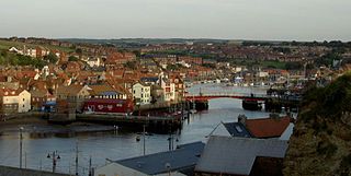
The River Esk is a river in North Yorkshire, England that empties into the North Sea at Whitby after a course of around 28 miles (45 km) through its valley of Eskdale. The river's name is derived from the Brythonic word "isca" meaning "water". The Esk is the only major river in Yorkshire that flows directly into the North Sea; all other watercourses defined as being major rivers by the Environment Agency, either flow to the North Sea via the River Tees or the Humber Estuary.

<span class="mw-page-title-main">Esk Valley line</span> Railway line between Middlesbrough and Whitby, England

The Esk Valley Line is a railway line located in the north of England, covering a total distance of approximately 35 miles (56 km), running from Middlesbrough to Whitby. The line follows the course of the River Esk for much of its eastern half.

<span class="mw-page-title-main">Esk Valley Walk</span> Long distance footpath in North Yorkshire, England

The Esk Valley Walk is a long distance footpath in North Yorkshire, England. The route first follows a loop on the North York Moors to the south of Castleton, then shadows the River Esk on its journey to the North Sea. Waymarking uses the symbol of a leaping salmon, with yellow arrows denoting footpaths and blue arrows bridleways.

<span class="mw-page-title-main">Grosmont, North Yorkshire</span> Village and civil parish in North Yorkshire, England

Grosmont is a village and civil parish situated in Eskdale in the North York Moors National Park, within the boundaries of the Scarborough district of the county of North Yorkshire, England.

<span class="mw-page-title-main">Castleton, North Yorkshire</span> Village in North Yorkshire, England

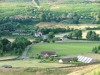
Castleton is a village on the River Esk, part of the civil parish of Danby in the county of North Yorkshire in England. It can be found 7.1 miles (11.5 km) south-east of Guisborough, in the North York Moors. There was once a medieval castle sited on Castle Hill that is thought to have been abandoned when Danby Castle was constructed.

<span class="mw-page-title-main">Kildale railway station</span> Railway station in North Yorkshire, England

Kildale is a railway station on the Esk Valley Line, which runs between Middlesbrough and Whitby via Nunthorpe. The station, situated 12 miles 65 chains (20.6 km) south-east of Middlesbrough, serves the village of Kildale, Hambleton in North Yorkshire, England. It is owned by Network Rail and managed by Northern Trains.

<span class="mw-page-title-main">Lealholm railway station</span> Railway station in North Yorkshire, England

Lealholm is a railway station on the Esk Valley Line, which runs between Middlesbrough and Whitby via Nunthorpe. The station, situated 11 miles 40 chains (18.5 km) west of Whitby, serves the village of Lealholm, Scarborough in North Yorkshire, England. It is owned by Network Rail and managed by Northern Trains.

<span class="mw-page-title-main">Glaisdale railway station</span> Railway station in North Yorkshire, England

Glaisdale is a railway station on the Esk Valley Line, which runs between Middlesbrough and Whitby via Nunthorpe. The station, situated 9 miles 33 chains (15.1 km) west of Whitby, serves the village of Glaisdale in North Yorkshire, England. It is owned by Network Rail and managed by Northern Trains.

<span class="mw-page-title-main">Egton railway station</span> Railway station in North Yorkshire, England

Egton is a railway station on the Esk Valley Line, which runs between Middlesbrough and Whitby via Nunthorpe. The station, situated 7 miles 66 chains (12.6 km) west of Whitby, serves the villages of Egton and Egton Bridge, Scarborough in North Yorkshire, England. It is owned by Network Rail and managed by Northern Trains.

<span class="mw-page-title-main">Grosmont railway station</span> Railway station in North Yorkshire, England

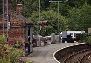
Grosmont is a railway station on the Esk Valley Line, which runs between Middlesbrough and Whitby via Nunthorpe. The station, situated 6 miles 24 chains (10.1 km) west of Whitby, serves the village of Grosmont, in the Borough of Scarborough, North Yorkshire, England. It is owned by Network Rail and managed by Northern Trains. The station is also served by heritage services operated by the North Yorkshire Moors Railway.

<span class="mw-page-title-main">Sleights railway station</span> Railway station in North Yorkshire, England

Sleights is a railway station on the Esk Valley Line, which runs between Middlesbrough and Whitby via Nunthorpe. The station, situated 2 miles 78 chains (4.8 km) south-west of Whitby, serves the villages of Briggswath and Sleights, Scarborough in North Yorkshire, England. It is owned by Network Rail and managed by Northern Trains.

<span class="mw-page-title-main">Ruswarp railway station</span> Railway station in North Yorkshire, England

Ruswarp is a railway station on the Esk Valley Line, which runs between Middlesbrough and Whitby via Nunthorpe. The station, situated 1 mile 30 chains (2.2 km) south-west of Whitby, serves the village of Ruswarp, Scarborough in North Yorkshire, England. It is owned by Network Rail and managed by Northern Trains.

<span class="mw-page-title-main">Goathland railway station</span> Railway station in North Yorkshire, England

Goathland railway station is a station on the North Yorkshire Moors Railway and serves the village of Goathland in the North York Moors National Park, North Yorkshire, England. It has also been used in numerous television and film productions. Holiday accommodation is available in the form of a camping coach.

<span class="mw-page-title-main">Egton Bridge</span> Village in North Yorkshire, England

Egton Bridge is a village in the Scarborough district of North Yorkshire, England. It lies within the North York Moors National Park, on the River Esk, between the villages of Glaisdale and Grosmont, about six miles south-west of Whitby, and on the route of the Esk Valley Walk.

<span class="mw-page-title-main">Glaisdale</span> Village and civil parish in North Yorkshire, England

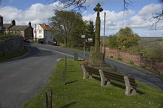
Glaisdale is a village and civil parish in the Scarborough district of North Yorkshire, England, within the North York Moors National Park.

<span class="mw-page-title-main">Lealholm</span> Village in North Yorkshire, England

Lealholm is a small village in the Glaisdale civil parish of the Borough of Scarborough, in North Yorkshire, England. It is sited at a crossing point of the River Esk, in Eskdale which is within the North York Moors National Park. It is 9.5 miles (15.3 km) by road from the nearest town of Whitby, and approximately 27 miles (43 km) from both Middlesbrough and Scarborough. The village is typical of those found all across the North York Moors which straddle the main through-routes along the valley bottoms. It is mostly built of local stone with pantiled or slate roofs.

<span class="mw-page-title-main">Ruswarp</span> Village in North Yorkshire, England

Ruswarp is a village in the civil parish of Whitby, in North Yorkshire, England. It is around 1.8 miles (2.9 km) from Whitby, at the junction of the B1410 and B1416 roads, on the River Esk and the Esk Valley Line, with trains stopping at Ruswarp railway station. Originally it was called Risewarp meaning 'silted land overgrown with brushwood'.

<span class="mw-page-title-main">Briggswath</span> Village in North Yorkshire, England

Briggswath is a village in the Scarborough district of North Yorkshire, England. the settlement is on the north bank of the River Esk, upstream of Ruswarp, and opposite Sleights which is on the south bank.

The Whitby Weighing Machine House is a grade II listed structure that is south of Whitby, North Yorkshire, England, between the Esk Valley line and the River Esk. The site was also where the original railway line allowed passengers to change into carriages pulled by horses on local roads, acting as the original railway terminus. The building is still largely extant, but mostly derelict, and is one of the few original Whitby and Pickering Railway (W&PR) buildings to still exist.

<span class="mw-page-title-main">Beggar's Bridge</span> Bridge in North Yorkshire, England

Beggar's Bridge is a packhorse bridge straddling the River Esk in Glaisdale, North Yorkshire, England. The bridge dates back to 1619 and was reputedly built by a former poor farm worker who wanted to meet his love but could not due to the river being in flood. Having become rich working at sea, then becoming the mayor of Kingston upon Hull, Ferris built the bridge at that point when flooding prevented him crossing it years before. The structure is both a scheduled monument and a grade II* listed building.

References

  1. "Esk | UK Environmental Change Network". ecn.ac.uk. Retrieved 2 June 2024.
  2. Kelman, Leanne (2020). Railway track diagrams 2: Eastern (5 ed.). Frome: Trackmaps. 63. ISBN   978-1-9996271-3-3.
  3. Smith, A. H. (1979) [1928]. The Place Names of the North Riding of Yorkshire. English Place Name Society. pp. 117, 119, 129. OCLC   19714705.
  4. Whitworth 2011, p. 92.
  5. Historic England. "Hunter's Sty Bridge (1021021)". National Heritage List for England . Retrieved 2 June 2024.
  6. Historic England. "Dibble Bridge over River Esk (Grade II) (1316231)". National Heritage List for England . Retrieved 2 June 2024.
  7. Hayes 1988, p. 59.
  8. 1 2 Page 1968, p. 336.
  9. 1 2 3 4 Bairstow, Martin (2008). Railways around Whitby volume one. Farsley: Bairstow. ISBN   978-1871944-34-1.
  10. 1 2 3 4 Kelman, Leanne (2020). Railway track diagrams 2: Eastern (5 ed.). Frome: Trackmaps. 48B. ISBN   978-1-9996271-3-3.
  11. 1 2 3 4 Jeeves, Paul (31 May 2012). "Major work to replace rail bridges". The Yorkshire Post. p. 15. ISSN   0963-1496.
  12. 1 2 Jervoise 1931, p. 62.
  13. Historic England. "Duck Bridge (Grade II*) (1302337)". National Heritage List for England . Retrieved 2 June 2024.
  14. Pevsner 2002, p. 135.
  15. "Shackleton Bridge 1947: Great Britain. Ordnance Survey". maps.nls.uk. Retrieved 9 June 2024.
  16. "Shackleton Bridge 1954: Great Britain. Ordnance Survey". maps.nls.uk. Retrieved 9 June 2024.
  17. Historic England. "Lealholm Bridge (Grade II) (1148587)". National Heritage List for England . Retrieved 9 June 2024.
  18. Pevsner 2002, p. 227.
  19. Page 1968, p. 349.
  20. "RailwayData | Bridges – MBW2 74 – River Esk, Rake Farm". railwaydata.co.uk. Retrieved 10 June 2024.
  21. "View map: Great Britain. Ordnance Survey, 45/70 – B (includes: Danby; Egton; Glaisdale) – 1951". maps.nls.uk. Retrieved 17 June 2024. At NZ784055
  22. "View map: Great Britain. Ordnance Survey, NZ70 – C (includes: Danby; Egton; Glaisdale) – 1954". maps.nls.uk. Retrieved 17 June 2024. At NZ784055
  23. Hayes 1988, p. 21.
  24. "RailwayData | Bridges – MBW2 81 – River Esk, Limber Hill, Carr End". railwaydata.co.uk. Retrieved 10 June 2024.
  25. Benham, Philip (2008). An illustrated history of the North Yorkshire Moors Railway. Hersham: OPC. pp. 28–29. ISBN   9780860936220.
  26. "RailwayData | Bridges - MBW2 83 - River Esk, Delves". railwaydata.co.uk. Retrieved 17 June 2024.
  27. Hayes 1988, p. 60.
  28. 1 2 3 4 5 6 7 8 9 10 Kelman, Leanne (2020). Railway track diagrams 2: Eastern (5 ed.). Frome: Trackmaps. 48C. ISBN   978-1-9996271-3-3.
  29. "RailwayData | Bridges - MBW2 90 - River Esk, Beckside Farm". railwaydata.co.uk. Retrieved 13 June 2024.
  30. Historic England. "Grosmont Bridge (Grade II) (1148748)". National Heritage List for England . Retrieved 15 June 2024.
  31. "Tramway bridge at Grosmont". maps.nls.uk. Retrieved 15 June 2024. Use the slider on the bottom left (named "Change transparency of overlay") to toggle between old mapping and modern-day satellite imagery
  32. "RailwayData | Bridges – MBW3 – Mbw3/43 Former Wagonway See Notepad". railwaydata.co.uk. Retrieved 15 June 2024.
  33. "RailwayData | Bridges – MBW3 44 – River Esk, Grosmont". railwaydata.co.uk. Retrieved 15 June 2024.
  34. "RailwayData | Bridges – MBW3 45 – River Esk, Birtley Farm". railwaydata.co.uk. Retrieved 15 June 2024.
  35. "RailwayData | Bridges – MBW3 46 – River Esk, Dorsley Bank". railwaydata.co.uk. Retrieved 15 June 2024.
  36. "RailwayData | Bridges – MBW3 47 – River Esk, Crag Farm". railwaydata.co.uk. Retrieved 17 June 2024.
  37. "RailwayData | Bridges – MBW3 48 – River Esk, Newbiggin South". railwaydata.co.uk. Retrieved 17 June 2024.
  38. "RailwayData | Bridges – MBW3 50 – River Esk, Newbiggin North". railwaydata.co.uk. Retrieved 17 June 2024.
  39. "RailwayData | Bridges – MBW3 51 – River Esk, Thistle Grove". railwaydata.co.uk. Retrieved 17 June 2024.
  40. "RailwayData | Bridges – MBW3 52 – River Esk, Sleights". railwaydata.co.uk. Retrieved 17 June 2024.
  41. 1 2 Whitworth 1998, p. 31.
  42. Smith, A. H. (1979) [1928]. The Place Names of the North Riding of Yorkshire. English Place Name Society. p. 119. OCLC   19714705.
  43. Thompson, Alan (2001). Cleveland and North Yorkshire (part 2). Kettering: Past & Present. p. 109. ISBN   1-8589-5054-6.
  44. "Dorman Long". The Times. No. 52310. 13 May 1952. p. 8. ISSN   0140-0460.
  45. Whitworth 1998, p. 23.
  46. Biddle, Gordon; Nock, O. S. (1983). The railway heritage of Britain: 150 years of railway architecture and engineering. London: M. Joseph. p. 39. ISBN   0718123557.
  47. "The Deck of the £1.8 million Whitby New Bridge". Evening Gazette. No. 34, 603. 18 September 1979. p. 7. ISSN   2056-6131.
  48. Woodhouse, Bob (22 May 2015). "On the railway route to Ruswarp" . Middlesbrough Evening Gazette. ProQuest   1682297149 . Retrieved 9 June 2024. ProQuest   1682297149
  49. "Swing Bridge". heritagegateway.org.uk. Retrieved 17 June 2024.
  50. "Dick Bridge". maps.nls.uk. Retrieved 10 June 2024.
  51. "Walker's Wath". maps.nls.uk. Retrieved 10 June 2024.
  52. "Lealholm Ford". maps.nls.uk. Retrieved 10 June 2024.
  53. Whitworth 2011, p. 52.
  54. Robinson 1991, p. 324.
  55. Newton, Grace (29 December 2023). "Glaisdale tragedy: Photos show 4x4 that was swept away in River Esk in Yorkshire two years before three men died at same location". The Yorkshire Post. Retrieved 10 June 2024.
  56. Moore, R. F. (1986). Paddy Waddell's Railway. Danby: North York Moors National Park Authority. p. 26. ISBN   0-907480-12-8.
  57. "Georeferenced Maps - Map images - National Library of Scotland". maps.nls.uk. Retrieved 17 June 2024.
  58. 1 2 Robinson 1991, p. 325.
  59. "Georeferenced Maps – Map images – National Library of Scotland". maps.nls.uk. Retrieved 17 June 2024.
  60. Bell, Stuart (10 April 2024). "A Stroll With Stu: take a springtime walk around Egton Grange, near Whitby". the Scarborough News. Retrieved 13 June 2024.
  61. "Georeferenced Maps – Map images – National Library of Scotland". maps.nls.uk. Retrieved 17 June 2024. Use the slider on the bottom left (named "Change transparency of overlay") to toggle between old mapping and modern-day satellite imagery
  62. 1 2 Page 1968, p. 514.
  63. Hayes 1988, p. 24.
  64. Benham, Philip (2008). An illustrated history of the North Yorkshire Moors Railway. Hersham: OPC. p. 28. ISBN   9780860936220.
  65. Whitworth 1998, p. 29.
  66. Whitworth 1998, pp. 25–26.
  67. 1 2 "View map: Ordnance Survey, Yorkshire 32". maps.nls.uk. Retrieved 9 June 2024.
  68. Waters, Colin (2011). A history of Whitby & its place names. Stroud: Amberley. p. 25. ISBN   978-1-4456-0429-9.
  69. Whitworth 1998, p. 19.
  70. Hayes 1988, p. 26.
  71. Jervoise 1931, p. 65.

Sources