The Cuyahoga River is a river in the United States, located in Northeast Ohio, that feeds into Lake Erie. The river is famous for having been so polluted that it "caught fire" at least 13 times, most famously on June 22, 1969, helping to spur the environmental movement in the US.
The Jordan River is a 24.9-mile-long (40.1 km) stream in the northwestern part of the lower peninsula in the U.S. state of Michigan. It is the largest tributary of Lake Charlevoix. The Jordan's headwaters rise from springs in the upper Jordan River Valley northeast of Mancelona in Antrim County. The Jordan River was the first river to be designated in Michigan's Natural Rivers Program.

The St. Joseph River is an 86.1-mile-long (138.6 km) tributary of the Maumee River in northwestern Ohio and northeastern Indiana in the United States, with headwater tributaries rising in southern Michigan. It drains a primarily rural farming region in the watershed of Lake Erie.
Tinker's Creek, in Cuyahoga, Summit and Portage counties, is the largest tributary of the Cuyahoga River, providing about a third of its flow into Lake Erie.

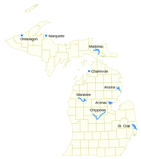
Pine River may refer to any of the following streams in the U.S. state of Michigan:
- Pine River. The main branch forms with the confluence of the East and West Branches of the Pine River at 44°29′38″N83°23′16″W in Alcona County. The South Branch joins approximately 1.5 miles (2.4 km) to the south and flows into Iosco County, where it empties into Van Etten Lake at 44°29′38″N83°23′16″W northwest of Oscoda.
- Pine River. The main branch is formed by the confluence of the North and Middle Branches northeast of Standish and flows into the Saginaw Bay of Lake Huron at 43°58′32″N83°51′16″W. The South Branch Pine River joins the main stream at 43°59′08″N83°53′17″W.
- Pine River is a short waterway, which along with Round Lake, connects Lake Charlevoix with Lake Michigan at Charlevoix.
- Pine River rises in Chippewa County and flows south through Mackinac County into the St. Martin Bay of Lake Huron at 46°03′09″N84°39′22″W The North Pine River, also known as the North Branch Pine River, joins at 46°12′20″N84°36′17″W. Another tributary, Hemlock Creek, is also known as Pine River.
- Pine River, also known as the South Branch Manistee River, rises in southeast Wexford County, flows southwest across northwest Osceola County, then west and north through the northeast corner of Lake County and back into southwest Wexford County, emptying into the Tippy Dam Pond on the Manistee River at 44°13′37″N85°54′27″W. The main stream is formed from the confluence of the East Branch Pine River with the North Branch Pine River at 44°06′02″N85°31′40″W. Another tributary, the Spaulding Creek, is also known as the Little Pine River
- Pine River, in Marquette County, is a very short stream draining Pine Lake into Lake Superior at 46°53′27″N87°52′13″W, north of the Huron Mountains.
- Pine River rises in from Pine Lake in eastern Mecosta County, flows mostly south and east through Isabella County, then south along eastern edge of Montcalm County, then east and north through Gratiot County and Midland County, emptying into the Chippewa River at 43°36′06″N84°17′33″W, just about two miles before it joins the Tittabawassee River near Midland. The South Branch Pine River joins the main stream at 43°30′37″N85°00′02″W Another tributary, Miller Creek, is also sometimes known as Pine River or the West Branch Pine River. The North Branch Pine River joins the main stream at 43°26′03″N84°50′18″W.
- Pine River empties into the St. Clair River at 42°49′13″N82°29′08″W on the south side of St. Clair. The South Branch Pine River joins the main stream at 42°58′11″N82°37′10″W. Another tributary, Quakenbush Drain, is also sometimes known as Pine River.
- Pine Creek empties into Lake Superior and is also known as the Pine River.

The Chippewa River is a stream in the U.S. state of Michigan that runs 91.8 miles (147.7 km) through the central Lower Peninsula. The Chippewa is a tributary of the Tittabawassee River and is thus part of the Saginaw River drainage basin. The river is named after the Chippewa people.

Tuscarora Creek in Berkeley County, West Virginia is an 11.4-mile-long (18.3 km) tributary of Opequon Creek, which drains into the Potomac River in the Chesapeake Bay watershed.
The Black River is a 41.1-mile-long (66.1 km) river on the Upper Peninsula of the U.S. state of Michigan, flowing mostly in Gogebic County into Lake Superior at 46°40′03″N90°02′57″W. Its source at 46°18′54″N90°01′15″W is a boreal wetland on the border with Iron County, Wisconsin. The northern section of the river, 14 miles (23 km) within the boundaries of the Ottawa National Forest, was designated a National Wild and Scenic River in 1992.

The San Jacinto River is a 42-mile-long (68 km) river in Riverside County, California. The river's headwaters are in San Bernardino National Forest, but the lower portion of the 765-square-mile (1,980 km2) watershed is urban and agricultural land. As a partially endorheic watershed that is contiguous with other Great Basin watersheds, the western side of the San Jacinto Basin is a portion of the Great Basin Divide.

Brandywine Creek is a tributary of the Cuyahoga River that is partly contained in Cuyahoga Valley National Park in Ohio.

Feather Falls is a rural unincorporated community in Butte County, California north and east of Lake Oroville. It lies at an elevation of 2982 feet. It is home to Feather Falls Elementary School, a K-8 facility. It takes its name from nearby Feather Falls, which was recently measured to be 410 feet tall. This concurs with the USGS Brush Creek 7½" quadrangle information.

Beaver Creek is an unincorporated community in eastern Washington County, Maryland, United States. Its population was 251 as of the 2010 census. It is located southeast of Hagerstown and north of Boonsboro near U.S. Route 40 and Maryland Route 66. The community is officially included in the Hagerstown Metropolitan Area. This town was founded in 1766.

Mill Creek Falls, is a waterfall located in the Rogue River Canyon within the Prospect State Scenic Viewpoint in Jackson County, in the U.S. state of Oregon. The waterfall is located at the south end of Mill Creek as it plunges into the Rogue River over a carved cliff surrounded by walls of petrified volcanic ash consequence of Mount Mazama eruption.

Desert Hills is an unincorporated community in Maricopa County, Arizona, United States. It is located in the New River census-designated place. Sitting on over 4.31 sq. mi. of the 85086 Zip Code, And the (623) Area Code, forming the southern boundary of Anthem and the western boundary of Cave Creek: about 30 miles (48 km) north of downtown Phoenix. Located east of the I-17, Desert Hills is roughly bounded by 35th Avenue to the west, Desert Hills Drive to the north, 28th Street to the east. The majority of Desert Hills sits north of Carefree Highway, however, a small portion resides south from Central Avenue to the west to 14th Street to the east: and south for one mile to Dove Valley Road. Note a community known as Tramonto, falls within these boundaries but is considered part of Phoenix.
Boyne River is a stream in Northern Michigan, named for the River Boyne in Leinster, Ireland. Together with the north and south branches, the river system has approximately 22 miles (35 km) of mainstream and the water basin drains 40,320 acres (163.2 km2). Boyne River is Lake Charlevoix's second-largest tributary, after the Jordan River.

The Jemez River is a tributary of the Rio Grande in the U.S. state of New Mexico. The river is formed by the confluence of the East Fork Jemez River and San Antonio Creek, which drain a number of tributaries in the area of the Jemez Mountains and Santa Fe National Forest. The Jemez River is about 50 miles (80 km) long, or about 80 miles (130 km) long if its longest headwater tributary, San Antonio Creek, is included. The East Fork Jemez River is about 22 miles (35 km) long. Both San Antonio Creek and the East Fork Jemez River flow through intricate meanders along their courses. The East Fork Jemez is a National Wild and Scenic River.
Mill Creek, also previously known as Tierken Kill, is a tributary to the Hudson River. Poetanock was the Native American name for the stream. From its source just west of Snyders Lake in East Greenbush the stream travels southwest, then north and west to the Hudson River. The stream has two waterfalls, the Upper Falls on the Mill Brook, and the Lower Falls on the Mill Brook. Its mouth on the Hudson River is directly opposite Albany New York at what was Van Rensselaer Island, in the City of Rensselaer.

Carlile Junction is the populated place in Wyoming where Wyoming Highway 24 has a terminus at US Route 14.

The Pennsylvania State Game Lands Number 147 are Pennsylvania State Game Lands in Blair County in Pennsylvania in the United States providing hunting, trapping, bird watching, and other activities.


