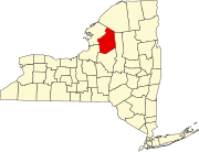
Hannawa Falls is a hamlet and census-designated place in St. Lawrence County, New York, United States. Its population was 1,042 as of the 2010 census. Hannawa Falls has a post office with ZIP code 13647. New York State Route 56 passes through the community.
Hunt is a hamlet and census-designated place (CDP) in Livingston County, New York, United States. Its population was 78 as of the 2010 census. Hunt has a post office with ZIP code 14846.
Linwood is a hamlet and census-designated place (CDP) in the town of York, Livingston County, New York, United States. Its population was 74 as of the 2010 census. Linwood had a post office until February 6, 1993; it still has its own ZIP code, 14486.
Livonia Center is a hamlet and census-designated place (CDP) in the town of Livonia, Livingston County, New York, United States. Its population was 421 as of the 2010 census. Livonia Center has a post office with ZIP code 14488, which opened on April 9, 1811.
South Lima is a hamlet and census-designated place (CDP) in Livingston County, New York, United States. Its population was 240 as of the 2010 census. South Lima had a post office from January 10, 1854, until April 17, 2010; it still has its own ZIP code, 14558.
Hankins is a hamlet in Sullivan County, New York, United States. The community is located along New York State Route 97 and the Delaware River, 8.2 miles (13.2 km) west-northwest of Jeffersonville. Hankins has a post office with ZIP code 12741.
Long Eddy is a hamlet in Sullivan and Delaware counties, New York, United States. The community is located along New York State Route 97 and the Delaware River in the westernmost corner of the county, 10.4 miles (16.7 km) southeast of Hancock. Long Eddy has a hotel/bar with outdoor barbecue, a historical society, fire station, public free river landing on the Delaware River as well as a post office with ZIP code 12760.
Mongaup Valley is a hamlet in Sullivan County, New York, United States. The community is located along New York State Route 17B 5 miles (8.0 km) west of Monticello, and along the Mongaup River. Mongaup Valley has a post office with ZIP code 12762, which opened on June 22, 1848.
McLean is a hamlet in Tompkins County, New York, United States. The community is 6.6 miles (10.6 km) west-southwest of Cortland. McLean has a post office with ZIP code 13102, which opened on June 30, 1826.
Blossvale is a hamlet in Oneida County, New York, United States. The community is 10.5 miles (16.9 km) west-northwest of Rome. Blossvale has a post office with ZIP code 13308, which opened on July 30, 1832.
McConnellsville is a hamlet in Oneida County, New York, United States. The community is located along New York State Route 13, 5.1 miles (8.2 km) southeast of Camden. McConnellsville had a post office from August 2, 1824, until February 26, 1994; it still has its own ZIP code, 13401.
West Leyden is a hamlet in Lewis County, New York, United States. The community is located in the town of Lewis along the East Branch of the Mohawk River at the intersection of New York State Route 26 and New York State Route 294, 6.6 miles (10.6 km) west-southwest of Boonville. West Leyden has a post office with ZIP code 13489, which opened on December 16, 1826. Today West Leyden is home to approximately 250 residents, a grocery store/gas station, church, two restaurants, garbage company, Volunteer Fire and Ambulance Department and Elementary School.
Woodgate is a hamlet in Oneida County, New York, United States. The community is located along New York State Route 28, 9.5 miles (15.3 km) east-northeast of Boonville. Woodgate has a post office with ZIP code 13494, which opened on December 19, 1878.
Brier Hill is a hamlet in St. Lawrence County, New York, United States. The community is located along New York State Route 37, 3.9 miles (6.3 km) south of Morristown. Brier Hill has a post office with ZIP code 13614.
Chase Mills is a hamlet in St. Lawrence County, New York, United States. The community is located along the Grasse River, 6.2 miles (10.0 km) east of Waddington. Chase Mills has a post office with ZIP code 13621, which opened on November 19, 1853.
Chippewa Bay is a hamlet in St. Lawrence County, New York, United States. The community is located along the Saint Lawrence River and New York State Route 12, 3.1 miles (5.0 km) west of Hammond. Chippewa Bay has a post office with ZIP code 13623, which opened on August 3, 1880.
Limerick is a hamlet in Jefferson County, New York, United States. The community is located in the town of Brownville at the intersection of state routes 12E and 180, 1.5 miles (2.4 km) north of Dexter. Limerick had a post office until June 1, 1998; it still has its own ZIP code, 13657.
Pyrites is a hamlet in St. Lawrence County, New York, United States. The community is located along the Grasse River, 5.7 miles (9.2 km) south of Canton. Pyrites has a post office with ZIP code 13677. Pyrites is also home to the Pyrites Volunteer Fire Department.
Raymondville is a hamlet in St. Lawrence County, New York, United States. The community is located along the Raquette River and New York State Route 56, 6 miles (9.7 km) north of Norwood. Raymondville has a post office with ZIP code 13678.
West Stockholm is a hamlet in St. Lawrence County, New York, United States. The community is located along the St. Regis River and U.S. Route 11, 5 miles (8.0 km) northeast of Potsdam. West Stockholm has a post office with ZIP code 13696, which opened on March 25, 1825.


