See also
Wikimedia Commons has media related to Old maps .
Cartography topics | |||||||||
|---|---|---|---|---|---|---|---|---|---|
| By continent | |||||||||
| By country or region | |||||||||
| By city | |||||||||
| History | |||||||||
| Individual maps |
| ||||||||
The following is a list of notable extant historical maps.
An atlas is a collection of maps; it is typically a bundle of maps of Earth or of a region of Earth.

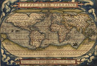
Abraham Ortelius was a Brabantian cartographer, geographer, and cosmographer, conventionally recognized as the creator of the first modern atlas, the Theatrum Orbis Terrarum. Along with Gemma Frisius and Gerardus Mercator, Ortelius is generally considered one of the founders of the Netherlandish school of cartography and geography. He was a notable figure of this school in its golden age and an important geographer of Spain during the age of discovery. The publication of his atlas in 1570 is often considered as the official beginning of the Golden Age of Netherlandish cartography. He was the first person proposing that the continents were joined before drifting to their present positions.
Theatrum Orbis Terrarum is considered to be the first true modern atlas. Written by Abraham Ortelius, strongly encouraged by Gillis Hooftman and originally printed on 20 May 1570 in Antwerp, it consisted of a collection of uniform map sheets and supporting text bound to form a book for which copper printing plates were specifically engraved. The Ortelius atlas is sometimes referred to as the summary of sixteenth-century cartography. The publication of the Theatrum Orbis Terrarum (1570) is often considered as the official beginning of the Golden Age of Netherlandish cartography.
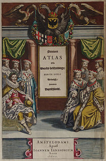
Johannes Janssonius was a Dutch cartographer and publisher who lived and worked in Amsterdam in the 17th century.

A world map is a map of most or all of the surface of Earth. World maps, because of their scale, must deal with the problem of projection. Maps rendered in two dimensions by necessity distort the display of the three-dimensional surface of the earth. While this is true of any map, these distortions reach extremes in a world map. Many techniques have been developed to present world maps that address diverse technical and aesthetic goals.

Willem Janszoon Blaeu, also abbreviated to Willem Jansz. Blaeu, was a Dutch cartographer, atlas maker and publisher. Along with his son Johannes Blaeu, Willem is considered one of the notable figures of the Netherlandish or Dutch school of cartography during its golden age in the 16th and 17th centuries.

Andrees Allgemeiner Handatlas was a major cartographic work published in several German and foreign editions 1881–1937. It was named after Richard Andree (1835–1912) and published by Velhagen & Klasing, Bielefeld and Leipzig, Germany.
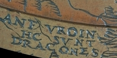
"Here be dragons" means dangerous or unexplored territories, in imitation of a medieval practice of putting illustrations of dragons, sea monsters and other mythological creatures on uncharted areas of maps where potential dangers were thought to exist.
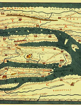
Tabula Peutingeriana, also referred to as Peutinger's Tabula or Peutinger Table, is an illustrated itinerarium showing the layout of the cursus publicus, the road network of the Roman Empire.
MelchisédechThévenot was a French author, scientist, traveler, cartographer, orientalist, inventor, and diplomat. He was the inventor of the spirit level and is also famous for his popular posthumously published 1696 book The Art of Swimming, one of the first books on the subject and widely read during the 18th century. The book popularized the breaststroke ; he was inducted into the International Swimming Hall of Fame in 1990. He also influenced the founding of the Académie Royale des Sciences.
The earliest known world maps date to classical antiquity, the oldest examples of the 6th to 5th centuries BCE still based on the flat Earth paradigm. World maps assuming a spherical Earth first appear in the Hellenistic period. The developments of Greek geography during this time, notably by Eratosthenes and Posidonius culminated in the Roman era, with Ptolemy's world map, which would remain authoritative throughout the Middle Ages.
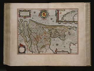
The Atlas Maior is the final version of Joan Blaeu's atlas, published in Amsterdam between 1662 and 1672, in Latin, French, Dutch, German and Spanish, containing 594 maps and around 3,000 pages of text. It was the largest and most expensive book published in the seventeenth century. Earlier, much smaller versions, titled Theatrum Orbis Terrarum, sive, Atlas Novus, were published from 1634 onwards. Like Abraham Ortelius's Theatrum Orbis Terrarum (1570), the Atlas Maior is widely considered a masterpiece of the Golden Age of Dutch/Netherlandish cartography.

Joan Blaeu was a Dutch cartographer born in Alkmaar, the son of cartographer Willem Blaeu.
The history of cartography refers to the development and consequences of cartography, or mapmaking technology, throughout human history. Maps have been one of the most important human inventions for millennia, allowing humans to explain and navigate their way through the world.

The cartography of Asia can refer to the representation of Asia on a map, or to depictions of the world by cartographers from Asia. Depictions of portions of Asia have existed on maps as early as the 6th century BCE, with maps being drafted to depict the Babylonian, Hellenistic Greek, and Han dynasty empires.

Frederik de Wit was a Dutch cartographer and artist.

Africae Tabula Nova is a map of Africa published by Abraham Ortelius in 1570. It was engraved by Frans Hogenberg and included in Ortelius's 1570 atlas Theatrum Orbis Terrarum, commonly regarded as the first modern atlas. The atlas was printed widely in seven languages and 31 total editions between 1570 and 1612.
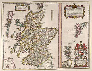
The book commonly known as Blaeu Atlas of Scotland, the fifth volume of Theatrum Orbis Terrarum Sive Atlas Novus, is the first known atlas of Scotland and Ireland. It was compiled by Joan Blaeu, and contains 49 engraved maps and 154 pages of descriptive text written in Latin; it was first published in 1654. Most of the maps were made by Timothy Pont, a Scottish cartographer. Those maps, made between 1583 and 1596, were collected, edited, and augmented with other maps by John Scot, Lord Scotstarvit, a Scottish laird.